Showing posts with label castle. Show all posts

Wednesday, 9 May 2012

Giro d'Italia Stage 5


All of Italy's ancient cities are full of historically important architecture and sites, and all have seen important events. Stage Four visits some that have more than most.

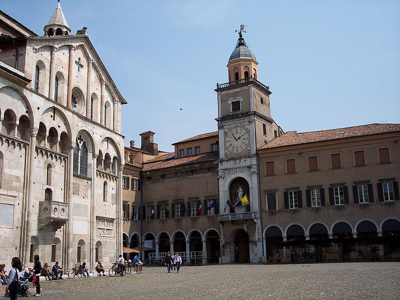
Cathedral and City Hall, Modena
Several places are worth seeing along the way. Modena is perhaps most famous nowadays as the home of Ferrari, Lamborghini, Maserati, Pagani and De Tomaso and for balsamic vinegar, but it has more than its fair share of monuments and historical buildings. Among those not to be missed are the Cathedral, begun in the 11th Century, home to the relics of Saint Geminianus (a 4th Century bishop of Modena, who tradition has it saved the city from the Huns by the rather un-Christian technique of producing a magic fog) and one of the earliest known depictions of scenes from the legend of King Arthur; the Ducal Palace and the City Hall, cobbled together during the 17th and 18th Centuries from various buildings dating from as far back as the middle of the 11th Century and forming one harmonious whole.

Collegio di Spagna, the oldest of the University' constituent
colleges
Bologna - where locals often tell you they've never heard of spaghetti bolognese - has even more, with the San Petronio Basilica (the world's fifteenth largest church), the spindly, precariously leaning Two Towers and the Baroque Cathedral especially worthy of note. It is home to a university, founded in 1088 and considered to be the oldest continually-operating example in the world. Described at the point of its foundation as "universitas magistrorum et scholarium," it gave us the word university. Once, Bologna had even more historical monuments; 44% of what once stood in the city was either completely destroyed or severely damaged during a single day of Alled bombing on the 16th of July, 1944. The city is sometimes known as La Dotta ("the learned one") on account of the University and sometimes as La Grassa ("the fat one") on account of its cuisine and prominent wealth.

Tiberius Bridge, Rimini
Rimini, where the race reaches the Adriatic, has despite being one of Europe's most popular holiday destinations and home to more than a thousand hotels, bars and clubs retained a great deal of historical sites including the Tiberius Bridge, begun in 14CE and finished seven years later (the race doesn't cross it, unfortunately) and the Castel Sismondo which, when built in the 15th Century, was outside the city; the fact that all of its towers face the city centre reveal that Sigismondo Pandolfo Malatesta, the nobleman who commissioned it, was afraid of attacks by his own subjects rather than outside forces (and a brief look at his history reveals that he was not an especially pleasant character: historian Francesco Guicciardini called him the "enemy of every peace and well-living" and Pope Pius II - who was a considerably better man that certain other popes through the ages and, rather peculiarly in the eyes of modern observers such as us, wrote a very successful and bawdy obscene play called Chrysis - accused him of "rape, adultery, and incest." Malatesta is also said to have rid himself of one unwanted wife by having a servant drown her, and the Duke of Urbino claimed that he committed incest with his own son).

Arco di Augusto, Fano
The race ends in Fano, where traces of the defensive walls built by Julius Caesar can still be seen. Th town was presented as a gift to the Frankish Kings of Germany in 754 by the Pope, but was returned to papal control in the 15th Century by Federico III da Montefeltro who had taken it from our friend Malatesta (it was Federico, in fact, who accused Malatesta of incest. Federico is the man in the famous painting by Piero della Francesca, wearing a red hat and showing his peculiar nose: he had his nasal bridge surgically removed, which must have been an unimaginably painful operation in those pre-anaesthesia times, to widen his eyesight following the loss of his right eye in an accident so that he would be better able to spot would-be assassins - because his enlightened beliefs, which included making all citizens equal under the law no matter what their social status, earned him as many enemies as friends). Fano, like Bologna, was once home to numerous towers erected by noble families in an effort to out-do one another, but none of them survive - some were destroyed by time and neglect, others by Napoleon, more during heavy shelling by the Austro-Hungarian Navy in the First World War and then by Allied bombing in the Second;then the last by retreating Nazi troops.

Tuesday, 20 September 2011

Copenhagen TT course

Rådhuspladsen - the start of all this year's races
(© Karri Huhtanen CC2.0)
All time trials begin and end at the Rådhuspladsen, Copenhagen's City Hall Square (55°40'37.32"N 12°34'4.66"E). However, the course varies depending on grouping with the Elite Men competing two laps of the route set out below; the Under-23 Men completing two laps of a shorter 17.6km course broadly similar to this one; Elite Women and Junior Men completing two laps and Junior Women one lap of a 13.9km course again based on this one. Maps of each course can be seen here.

The riders then set out north-west along the Hans Christian Andersen Boulevard, the busiest street in the city with several bus-stops thus leading to the possibility of diesel spills on the road surface - however, the Danes are famous for their clean towns and cities, so the road will in all likelihood have been well-scrubbed shortly prior to each race. One particularly tricky spot for this reason will be the medium right turn at the north-western corner of Ørtedparken to join Øster Farimagsgade. Ørtedsparken, a public park, occupies the site of a military complex decommissioned in the latter half of the 19th Century, the defensive moat now forming part of the park's lake, and is named after Hans Christian Ørsted - the first scientist to notice that electrical current creates a magnetic field.

Ørtedsparken (public domain image)
The road is straight, wide and flat; as such, it's unlikely to cause any problems over the 0.73km section leading to the Botanisk Have gardens. Once past the extensive glasshouse, a very slight deviation to the left leads to Copenhagen's oldest cemetery to remain in use, Holmens Kirkegård which contains among many graves belonging to famous occupants that of the artist Heinrich Hansen. At the end, when the lake on the left comes into view, a slight left leads for approximately 48m along Dag Hammarskjolds Allé to a tighter right onto Classensgade (55°41'47.04"N 12°34'49.71"E) - this is another section where diesel spills are a potential hazard. Classensgade, though considerably narrower than Hans Christian Andersen Blvd. or Øster Farimagsgade is nevertheless easily wide enough for a peloton, never mind a single time trialer, along its entire dead straight 0.69km stretch.

A 90 degree left at the end carries the riders out onto the left-hand lane of Strandboulevarden (55°41'57.27"N 12°35'24.74"E) - anyone who attempts to take the corner too fast will be at risk of running straight into the central reservation which, since it has trees, could be a race-ending crash. Also, being another main route with several bus-stops, spilled diesel again poses a risk, as could the several pedestrian crossings along the way as the painted sections can become slippery when wet. With the exception of a very slight kink in the middle just past what was until very recently the Danmarks Designskole (it's since moved and merged with the School of Architecture), the road is straight for 1.18km. It then curves left, with riders again needing to be cautious to avoid the central reservation, and continues for a further 0.42m to a tight right-hander into the left lane of Østerbrogade (55°42'42.67"N 12°34'39.03"E).

Looking north along Osterbrogade from the Trianglen. The
riders will join the road more than a kilometre further along
(© Leif Jørgensen CC1.2)
As Copenhagen's premier retail location, Østerbrogade has several bus-stops and will receive many truck deliveries each day. It is, as unfortunately tends to be the case with all shopping streets around the world these days, is studded with the usual purveyors of McGreaseburgers - the wrappers of which are surprisingly lethal if caught beneath a a wheel; however, other than the bend at the end leading to the Ryvangs Allé, it's completely straight for the full 0.82km length, reducing the hazard for mush of the section. They follow the road for 1.88km, crossing a fly-over after 1.33km, then arrive at an intersection. Passing through takes them onto Gersonsvej.

After another straight section, this time of 0.87km, the route arrives at another intersection and crosses straight over and into a slight left followed by a gentle right. The road turns straight for 0.24km, then turns a medium-tight right onto Bregnegaardsvej. This leads into a sweeping left 0.14km later, followed by another straight 0.94km heading into the Charlottenlund Slottspark, starting at the Forstbotansk Have (forest park) on the right. The section lasts for approximately 0.49km after the Viggo Rothes Vej, then the riders turn right onto Jægersborg Allé.

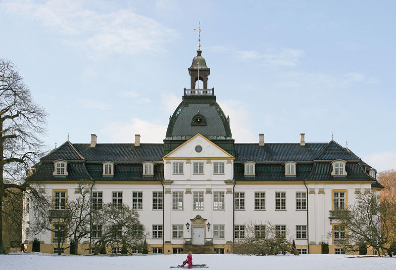
Charlottenlund Palace (© Henrik Jessen CC3.0)
From road level, the first good look at Charlottenlund Palace comes after 0.25km as the road follows a gentle curve left. Named after Charlotte Amalie, sister of Christian VI, it was originally constructed in the Baroque style but remodelled in the French Renaissance style around a decade after it became home to Crown Prince Frederick - later to become Frederick VIII - and his bride Lovisa Josefina Eugenia of Sweden adopted it as their home (Lovisa sounds to have been rather a likable character - permitted to be herself by her remarkably liberal father Charles XV of Sweden rather than being trained to do what she was expected to do, she became a bit of tomboy and got up to all sorts of things that young ladies were not supposed to engage themselves with, for example - shock, horror - swimming. Her mother, though on the whole considering it important to behave as ladies should, was also a fan of the sport and between the two of them they made it a fashionable and acceptable thing for women to do, thus opening the way for women of their time to become involved not just in swimming but a range of other sports too). Though she was, a little surprisingly, very strict with her own children, she had little time for court and formalities; those who met her describing her as being funny, friendly and easy to get along with. She created a number of charities aimed at improving the lives of various groups in society and enjoyed enormous popularity among the public.

Jacobson's influence spread far beyond Denmark. This, his
building for St. Catherine's College, is in Oxford.
 (© Bbacambridge CC2.5)
Charlottenlund, a town in its own right, has become one of the most affluent suburbs of Copenhagen and boasts many mansions and great buildings including several by the notable architect Arne Jacobson in the Danish Modernist style and considered of international importance. Having been influenced whilst still a student by the great Swiss architect Le Corbusier, Jacobson later traveled to Germany where he was exposed to the revolutionary work of Gropius, van der Rohe and the Bauhaus; incorporating their rationalist design philosophy into his own work. In 1929, he won first place in a competition to design the House of the Future, the design then being realised in full scale at the Forum København - which, incidentally, was also home to a six day annual bike race for the first few years of its history. The House was an immediate a enormous success, firmly establishing its designer as the architect to go to for an ultra-modern house. However, his considerable talents didn't stop with architecture - he designed a wide range of furniture including four items that have became among the most iconic of the 20th Century: the Ant, Model 3107, Egg and Swan chairs, all heralded in the 1950s as perfect amalgamations of functionality and aesthetics and - as unlicensed copies at least - still available to this day when Jacobson, who had to flee by rowing boat to Sweden to escape deportation to a concentration camp under the Nazis due to his Jewish roots, is alongside the Finn Alvar Aalto widely considered to be one of the people responsible for forming the overall look of the last century.

Øregård Museum (© Henrik Jessen CC3.0)
After gentle left and right bends potentially made slippery by fallen leaves, the road heads straight for 0.46km until it reaches a 90 degree right turn onto Strandvejen by the Akvarium (55°44'54.56"N 12°35'14.13"E). To the left is Charlottenlund Fort, a coastal battery constructed during the 1880s to protect the northern sea approaches to Copenhagen. The road continues, straight but for a few unchallenging and gentle bends, for 2.6km south to a 90 degree right turn onto Ehlersvej. 1.23km before the turn is the Øregård Museum in the Hellerup district, housing a collection of more than 3000 paintings depicting Copenhagen and its environs and housed in a neoclassical mansion built in the early 19th Century by a rich merchant. Hellerup is also home to the headquarters of Saxobank. To the left as the riders approach the turn is a harbour and huge business park, home to the Tuborg brewery.

0.33km later, they take the easy left turn back onto the Ryvangs Allé, taking the left lane so as to avoid cyclists further down the start list heading in the opposite direction. After 1.3km, they turn probably the most dangerous corner on the parcours, an extremely tight left to enter Svanemøllevej. The road seems unusually wide for a residential street, the reason for this being that it was constructed to relieve heavy traffic on the nearby Strandvejen and, in the past, carried trams as well as cars and time trial bicycles. A very affluent area, each house is unique with some deserving special note: Number 3 was deliberately destroyed by an explosion during the Nazi occupation and was subsequently be a modern villa built in 1961 and Number 14 has a large hidden basement built underneath a normal, unconcealed basement, complete with a tunnel leading to a second section hidden below the garden. It's not known who built it, but it can be reliably dated to the Nazi occupation and evidence suggests it was used to covertly hide Jewish citizens until they could be transported to safety in Sweden. Several others are currently occupied by foreign embassies.

The entrance to Strandboulevarden from Osterbrogade.
Note the trees in the centre - extreme caution will be
required to avoid hitting them if it's as wet as it is in
this photograph (© Leif Jørgensen CC3.0)
Vangehusvej is 0.29km from the corner, with the riders turning right onto it. They then turn right again after 0.11km onto Strandvejen., one of Denmark's oldest roads and which heads in the opposite direction for 38km to Helsingør - better known to we English speakers as Elsinore, site of Hamlet's castle. Reaching the bridge over the railway 0.4km later, the riders pass onto Østerbrogade and once again remain in the left lane so as to avoid oncoming riders, doing the same 0.73km later after the tight right turn into Strandboulevarden.

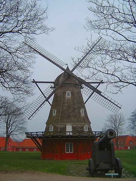
Having traveled the opposite way around the same bend as earlier, they change after 1.4km to the right lane and join with Kristianiagade as it continues south, then south-west for 0.49km to a tricky left turn by the Østerport Station onto Oslo Plads before passing onto Grønningen. To the left is the 17th Century Kastellet (55°41'30.41"N 12°35'39.76"E), the best-preserved fortified citadel in Northern Europe.

Being higher than the surrounding areas, the
ramparts were the ideal place to position
windmills. This one still stands inside the
Kastellets (CC1.0)
With a history beginning in 1626, during the reign of Christian IV who was unable to realise his full plans for the site when finances ran out, the first noticeable thing about the Kastellet is its striking pentagram shape, not dissimilar to the fort at Briançon we saw right back in July during Stage 18 of the Tour de France, a design intended to to provide 360 degree cover of the surrounding area and to leave no point or corner along the defensive walls unprotected. The second thing that those tourists who are paying attention notice is that the castle reveals Copenhagen was not always the content, happy and democratic place that it is today: the design is carefully laid out so as to be every bit as effective at protecting its occupants from the city as it is at protecting the city from sea-borne attack - all that would be required would be to turn the guns and point them in the opposite direction for any civil unrest to be rapidly quelled long before it could develop into revolution. Building began again under Frederick III (hence the official name Citadellet Frederikshavn), Christian's successor, who employed the notable Dutch military architect Henrik Ruse to develop the site.

Copenhagen's fortifications in 1728 (public domain image)
Ruse, having seen much active service in a number of different armies, had written a respected book on the subject of fortifications and whilst carrying out research had visited numerous ancient and modern defensive sites throughout Europe; distilling what he observed and learned down into a highly effective new set of techniques. The Kastallet's dual purpose as defender and oppressor was evidently not lost on locals, for Ruse received a number of death threats during his stay in Copenhagen. He was also charged with extending and developing the city's walls, leaving it with some of the most efficient, effective and up-to-date defenses anywhere in the world by the end of the 17th Century. However, military technology moved on rapidly and within less than a century suspicions began to arise that the walls wouldn't be up to the task of protecting against modern warfare. This proved to be the case in 1807 when they proved to be utterly useless in preventing the British - who feared Napoleon might invade Denmark and use the castle and navy to block British access to the Baltic Sea - from bombarding the city, destroying almost a third of its buildings and killing some 2000 civilians. The decision to decommission the fortifications was made in 1842 after two years of studies and deliberations - however, little happened other than attempts to strengthen some sections due to the Schleswig War of 1848. Today, the only remaining parts are the Kastellet and a section lying partially in a public park and partially in the unique Freetown Christiania.

View from the top of the Marmorkirken, across Amalienborg
Slotsplads and towards the Opera House (public domain image)
Having reached the end of Grønningen, the route turns left onto the much narrower Esplanaden ending with a very tight right after 0.22km onto Amaliegade, once the site of the city's General Hospital. After 0.41km, they arrive at Amalienborg Slotsplads, the Palace Square with a palace occupying each of the four corners. Once of Europe's finest public spaces, the Square offers excellent views north-west to the Marmorkirken (Marble Church) and south-east to the modern Opera House - a view the riders will be able to appreciate as they turn left and head in that direction between the easternmost palaces before turning right onto Toldbodgade; a turn that could prove extremely hazardous in the wet due to the slippery stripes of a pedestrian crossing sufficiently wide as to be unavoidable when exiting the Square.

Continuing south-west for 0.46km, the route arrives at Nyhavnsbroen Bridge and crosses onto Holbergsgade before keeping left around a bend 0.18km later to join Cort Adelers Gade as it leads south-west along the edge of the docks. After 0.31m, they arrive at a left turn onto Christian IV's Broen, bringing them onto Slotsholm, originally a a collection of tiny islets and, from 1167, Bishop Absalom's castle; the construction of which is traditionally cited as the beginning of Copenhagen. They then pass under a fly-over onto Christian's Brygge before a right turn 34m later for Slotsholmengade, following the street for 0.28km and turning left into Rigsdagsgarden alongside the Christiansborg Palace shortly before it becomes Tøjhusgade (55°40'34.05"N 12°34'51.39"E).

Christiansborg Palace, built on the site of Bishop
Absalom's castle (© Eimoberg CC2.0)
The Palace houses the Folketing (pariament), Prime Minister's office and Supreme Court, thus making it the only building in the world to house all three branches of government (executive, legislative and judicial). The current building dates from the early 20th Century; having been constructed on the site of an earlier palace begun in 1803 - when completed 25 years later, King Frederick VI decided it wasn't up to his exacting standards and declined to move in, using it solely for entertaining guests. His successor, Frederick VII, lived in the palace for 11 years, leaving in 1863. 21 years later, all but a few sections were destroyed by fire. Prior to 1803, the same site was occupied by the original Palace; upon which construction began in 1733 - it too was eventually destroyed by fire just 61 years later. Before the first Palace, Copenhagen Castle stood here; as it had done since a few years after the original occupant, Absalom's castle, was destroyed at the hands of the Hanseatic League in 1369. Remodeled and modernised in the 1720s by Frederick VI, bad engineering meant that the newly-strengthened walls cracked under their own weight; leading to demolition in 1731 to free up space for the first Palace. Remains of Absalom's castle were unearthed during excavation work to create the foundations of the new Palace and are open to the public.

Having come to the end of Tøjhusgade, the riders cross Prinsens Broen and enter Ny Kongensgade; crossing Vester Voldgade and arriving at Hans Christian Andersen Blvd. after 0.26km. They turn right, once again taking care to avoid diesel patches, then enter the final section to the finish line at the City Hall 23.2km from the start.

Thursday, 15 September 2011

Tour of Britain - Stage 6 Guide

Cheddar Gorge
Stage Map: click here
Stage Profile: click here
More Stage Guides: click here

In our ever-ongoing attempts to enlighten the general public to the wonder that is professional cycling, we've been singing the praises of the Tour of Britain down the pub. One common reaction - other than "blimey, are you still banging on about that?" - is "isn't that a bit boring? I mean, we haven't really got the mountains here, have we?"

Taunton's parish church, rising high
over the County Cricket Ground
They'll think again if they watch today's Stage 6, however. We may not have the high Alps or Alto de l'Angliru, but the two Cat 1 climbs in the latter half of the race are as challenging as anything the Tour has to offer - they just don't last as long, that's all, topping out at a little bit shy of 300m. The first one, at Cheddar Gorge, is a virtual wall for the first part, slackening only slightly halfway up; the second at Bristol Hill is a killer all the way up. And what's more, the teams need to ride more than 80km of the 146km total just to get there.

The race starts in Taunton, a village in Iron Age times and later a city of some importance during the Saxon era when it had its own mint and, from 710 CE, a castle (though it was destroyed just 12 years later to prevent it being taken over during a rebellion). It became the County Town of Somerset in the 15th Century, just in time to play an important role in the War of the Roses and the Cornish Uprising - it was here 1497 that the Cornish army surrendered, their leader Perkin Warbeck having panicked and fled when he heard the King's soldiers were on their way to the town. Many were executed as an example to others of what fate awaited those who dared oppose the monarch - perhaps giving rise to the various ghosts allegedly seen around the buildings.

Taunton Castle
There are traces of Saxon buildings at the present castle, though the 8th Century castle is believed to have been elsewhere, but the site wasn't fortified until the Normans built a stone fortress following the Conquest. In time, this was much altered and became a bishop's palace; then in 1138, Bishop of Winchester Henry of Blois began converting it back,, developing and adding to it until it became a mighty and important castle. Many more additions were made by his successors with the most newly-built structure in the complex being a schoolhouse dated to 1520. By 1600, the castle was a decaying ruin but it gained a new lease of life during the Civil War, being renovated and put back into use to become the only Parliamentarian stronghold in the South-West of England. The keep was demolished after the war, its sturdy base remaining today to give some idea of its imposing scale.

Today, Taunton enjoys Strategically Important Town or City status, permitting it to apply for large-scale funding to pay for regeneration and improvement projects. Part of this includes efforts to support sustainable living and transport, hence the new cycle paths granting off-road access to virtually all parts of the town. The Taunton Freeriders, a community mountain bike project, are working alongside the Forestry Commission to build world-class downhill and North Shore-style facilities nearby; a project that, going on the record of various similar projects around the country, will bring considerable income to the area.

As ever, the stage begins with a neutral zone to ensure all riders are rolling and ready to start racing without the mass pile-ups and carnage that tend to ensue if the entire peloton set off from a standing start. It begins on East Street near the County Walk shopping centre, right in the heart of town and near the corner with North Street (51° 0'51.97"N 3° 6'2.10"W), which the riders will travel up and over the bridge before turning right onto Station Road. They'll then turn right again and cross back over the river on Priory Bridge Road and head past the first roundabout to take the first exit at the next onto the Obridge Viaduct. When they reach the roundabout on Priorswood Road, they'll turn right and ride along the A3259 through Prior's Wood and Minkton Heathfield to the A38; then move onto the A361 towards the bridge over the M5 motorway. The racing begins 200m past the entrance to Durston Elms garage (51° 2'53.06"N  3° 1'26.47"W), having covered precisely 8km since East Street.

Gargoyle, North Curry (© Celiakozlowski CC3.0)
The first section of the race into West Lyng is unremarkable, being straight and flat on a wide modern road - the sort of place where nobody wants to try to start a breakaway attempt because it's just too easy for the peloton to catch them. After turning right onto New Road nothing much changes, though the road narrows slightly as it passes over a bridge 0.52km along the road and again 0.22km after the crossroads before the race arrives at North Curry - established by the Saxons, a royal manor in the 11th Century and a market village since the 13th, North Curry is a little-known beauty spot that boasts no fewer than 68 buildings listed for their architectural or historical significance.

The roadbook seems to take a little departure from reality at this point, instructing us to turn right at the T-junction on the A358 0.8km after North Curry. The only problem is, the A358 comes no closer than 3.86km - this, obviously, confuses matters somewhat. We think that the route planners arrived at the T-junction in the village and saw a sign directing traffic along Windmill Hill towards the A358. It then instructs us to turn left at a junction 100m ahead onto a road called Greenway, which proves entirely possible, and stating that we should arrive at a T-junction with the A378 2.3km later for a left turn towards Langport - this also turns out to be possible, so it looks as though we're on the right route.

Burton Pynsent Monument
(© Pam Goodey CC2.0)
Once on the A378, it's just 0.96km to the start of the stage's first climb, a Category 3 starting as the peloton pass a white building on the left of the road after 9.4km (51° 0'21.63"N 2°57'33.10"W) and finishes 1.6km later at the Green Shutters Nurseries (51° 0'14.09"N 2°56'13.76"W) just outside Fivehead having climbed approximately 50m. The race then enters what would have been a rather boring 4.2km transitional section were it not for the presence of Burton Pynsent House. T large and very grand stately home was built in 1765 for William Pitt, the leader of the British Government during the Seven Years' War and a highly unusual politician for his day (and our day, come to think of it) in that he secured his place in Parliament and political success not through familial connections but through hard work and his own skills. Remarkably, the current House is just one wing of the older original, the rest having been demolished in 1805. Nearby is the 43m tall Burton Pynsent Monument, designed by Capability Brown under the employment of Pitt as a monument to Sir William Pynsent. It cost the vast sum of £2000 to build in 1757.

The Hanging Chapel, Langport (© Pam Goodey CC2.0)
After 15.2km, the race arrives at Curry Rivel, taking the road straight through the town and on towards Langport, a small town that appears home to far more than 1100 people at first glance due to being formed of two parts which together give the impression of a far larger, sprawling place. The lower half, situated along the banks of the river, was the port; once a busy place in the days when Somerset's most navigable river was the preferred way to carry goods into the heart of the county. The tilting houses of Bow Street, their unusual angles cause by subsidence, are the highlight of the lower town. The upper half exists purely because of the topography's strategic value, being easily defended from attack.

The village has been settled and of some importance for a very long time, as made evident by the numerous Roman villas found nearby and the value placed upon it in the Domesday Book, which estimated the total worth of the village, manor and property to be a hefty £70, 10 shillings and sevenpence. Langport is famous as the site of an eponymous Battle in 1645, one of the most decisive of the Civil War as it saw the destruction of the last effective remnants of the Royalist army who attempted to escape by setting fire to the lower town, thus preventing the Parliamentarians from following. Visitors who appreciate ancient architecture should not miss the Hanging Chapel, built on the site of a gateway through the defensive earthworks in the days when Langport was a Saxon village. The present building was constructed at some point during the 13th Century. Having falled out of use as a chapel, it later housed a grammar school, then a Sunday school, then a museum, then an armoury and, since 1891, a masonic hall. The deep gouges in the stonework were caused by a truck in 1998.

Having entered the via Bow Bridge, the riders start the first of the day's sprint sections as they pass between a clock on the left and Langport Travel on the right (51° 2'15.37"N), the keep left to follow the road up into the town and around to the right until they arrive at the junction with the A372. The first 0.95km of the road as it passes through town is straight and unchallenging, but the very tight 90 degree bend at the end could prove hazardous especially during or after rain. There are two more difficult bends, a medium right after 0.9km and a medium-tight left 0.16km later on the way into Huish Episcopi (yes, a great name - one of our favourites) and Pibsbury before the road continues past Long Sutton and Catsgore. After 31.3km, just south of Kingsdon, the Tour arrives at a junction with the B3151 and turns a tight left to head along the road which is much narrower, thus potentially causing problems when the peloton have to slow and take turns finding a place in the new longer, thinner peloton that will be necessary to continue. There's another right bend, medium tightness, 0.64km after the race emerges from the woodland a short way on.

Somerton (© Liz Martin CC2.0)
After 34.4km, the race reaches Somerton, a small town with a name believed to be derived from either the Old English saemere tun or the Saxon sumer-tūn; both meaning "summer town" and suggesting, perhaps, a place known as a summer stopping point for earlier nomadic people. In time, the entire country became known as Sumortūnsǣte, "the people who live at and depend upon Sumortun" which eventually, having been Somersæte in 845, became Somerset. And we're sure you'll agree, there's no other cycling website where you learn things such as that.

The race keeps left as it passes the town, soon arriving at Littleton and then Compton Dundon. Reaching a five-way crossroads 1.9km later, the peloton take the second left onto Cockrod Road which will no doubt amuse some riders and fans. The remainder of the road stretches for 4.8km until it arrives at the A39 when the race turns left, passing south-west of Ashcott and arriving at a turn on the right after 2.3km leading onto Shapwick Hill. The drinks station begins 1km later.

4.2km ahead, a left turn leads onto Burtle Road and into Burtle. The road kinks slightly to the right, becoming Mark Road which remains almost perfectly straight for the following 1.44km, then turns a medium left before running straight for another 0.44km to a medium right. 0.25km later it enters a tighter right followed immediately by a narrow bridge - another potential hazard if riders pile up at the entrance.

St. Michael's, Blackford: the perfect English village church?
(© Dave Lowther CC2.0)
The route turns left onto Southwick Road 2.2km later, passing straight through a crossroads and coming to a narrow section 2km later. At a T-junction 0.5km later, it turns right onto the B3139 and passes through Mark Causeway, past a truck depot on the left - diesel spills here are less likely to cause crashes than usual due to straight road - before arriving at Mark 67.9km from the start of the race. There are two tight bends, a left with a right 0.13km later, just as the riders enter the village. After 70.8km, at the sign for Blackford, the feeding station starts.

At the centre of the village, the road bends sharply to the right and becomes New Road for 0.25km, then changes name again to Sexey's Road. Yes, really. 0.7km later, at the crossroads, the feeding station ends and the peloton continue straight ahead towards Wedmore, once home to Britain's first mental hospital; established by Doctor John Westover in the 17th Century. It appears that Dr. Westover had remarkable beliefs for his time as to how the mentally ill should be treated, dealing with them compassionately rather than condemning them to the harsh punishments and squalor found in asylums of the day. He also kept careful record of changes in their condition and illnesses suffered by the people in the village, a system that may well have allowed him to make valuable insights and perhaps achieve far more success in improving his patient's lives than other hospitals which were frequently little more than prisons.

Having followed Pilcorn Street through the town, the riders arrive at Church Street and pass by the grand Church of St. Mary where a hoard of 200 Saxon silver coins were discovered in 1853, arriving presently at a T-junction with the B3151 where they turn left onto Cheddar Road. They keep right as they pass through Cocklake (stop sniggering please, this isn't even nearly the funniest name so far on this stage) then arrive at the A371 after riding 80.8km since the start. Turning right, they pass into Cheddar and after 0.2km arrive at a left-turn leading onto another section of B3151 and take the second exit at the roundabout a short way ahead.

Real Cheddar cheese, maturing deep in a cave at the Gorge
(© Gary Bembridge CC2.0)
Somewhat surprisingly given its large geographic size and population of a little over 5000 people, Cheddar remains officially a village. It has been inhabited continuously since the Neolithic period, the skeleton of a Neolithic villager - Britain's oldest complete skeleton - having been discovered here in 1903. Remarkably, DNA analysis of a Neolithic skeleton from the area a few years ago was able to discover a direct descendent among the modern population. Palaeolithic remains, dated to 13,000 before the present, have also been discovered nearby.

The village is famous for its cheese which, often in sadly reduced and flavourless form, has become the most popular cheese in Britain. People who have not experienced the real Cheddar cheese, however, will be surprised by the powerful, earthy, nutty flavour of the real Cheddar which is still made here by the Cheddar Gorge Cheese Company who age their product deep in caves along the Gorge.

Cheddar Gorge
Of course, it's the Gorge itself that made the village famous. By far the largest example of its kind in Britain and 137m from bottom to top at the deepest point, it was listed among the Four Wonders of Britain as long ago as 1130 and won second place behind the Dan yr Ogof caves in Wales in a poll to find the Seven Wonders of Britain in 2005. Formed over 1.2 million years by the actions of water on limestones, there are extensive caves leading away from the Gorge - Gough's Cave, discovered in 1903, extends for 400m while the smaller Cox's Cave has many very impressive geological features. One smaller cave houses a popular children's educational attraction called Crystal Quest, others are home to colonies of rare Greater and Lesser Horse-Shoe bats.

The stage's second sprint begins outside the Cox Mill Hotel on Cliff Street at the 81.9km point and leading immediately into the first categorised climb - Cat 1 Cheddar Gorge. Immediately upon entering the Gorge, 70m past the tea shops and cafes at the south-western end, the road negotiates the first hairpin. It's a right-hander, not too tight or steep and leads into a twisty 0.6km section to the next hairpin, another right and also not tight but considerably steeper. The remainder twists and turns, though no bends are particularly hazardous due in part to the slow speeds because of the climb, to the climb's end 5.1km later at a lay-by near a junction.

The following 15.3km are straightforward, remaining on the same road as it heads through various crossroads and past some villages with fantastical names - Priddy (look for the nine round barrows, ancient burial mounds, in a field to the right of the route just past Nine Barrows Lane and the three mysterious round earthworks in a row in the field on the other side of the road), Red Quar (which sounds strangely like the name of a piece of music to Aphex Twin fans) and Green Ore - before reaching a crossroads at the A37 by a pub called The Olde Mendip Inn; at which point the riders have completed 102.3km from the start. Here, they turn right and then pass straight through more crossroads 1.7km later before arriving at Shepton Mallet 1.5km later.

The Anglo-Bavarian Brewery (© David Ward CC3.0)
Shepton Mallet is the rather surprising home of the Anglo-Bavarian Brewery established in 1864 - it got its name when the owners employed Bavarian brewers to set up lager production here, and in doing so became the very first brewery in Britain to brew lager. It went out of business in 1920 and the grand building now sits amid an industrial estate, seemingly condemned to dilapidation despite its Grade II Listed status and inclusion on the Heritage at Risk Register. Also boasting Grade II status is Her Majesty's Prison Shepton Mallet, the oldest prison still in use in the United Kingdom having been opened in 1625. Like all prisons, it has much darkness in its history - the grounds contain the unmarked graves of at least seven people, but the number of executions carried out here before 1889 is unknown. It was closed in 1930, briefly being used to store important and secret documents until becoming an American military prison for two years until the end of the Second World War and seeing the executions of eighteen servicemen for various crimes. It became a British military prison after the war, then a civilian prison again in 1966. The gallows were removed in 1967, the room that housed them is now the library.

The roadbook says that the route follows the B3156 Waterloo Road through the town to the A371; but this is another error because Waterloo Road is actually the B3136. When the race arrives at the A371, riders take the third exit from the roundabout for Commercial Road and head into Croscombe (incorrectly spelled Crosscombe in the roadbook) 2.5km further on and staying left as the pass by Dulcote a short way ahead.

Wells Cathedral (© seier+seier CC2.0)
After 114.8km, the Tour reaches Wells, England's second smallest city with a population of around 10,500 people (St. David's, in Wales, is the smallest in Britain with just 1797 inhabitants). However, it has one of the grandest cathedrals in Europe, the seat of the Bishop of Bath and Wells. Construction began here in 1175 on the site of an earlier cathedral dating to 704. It was dedicated just over 60 years after work began in 1239, but the building was not completed for another two and half centuries until 1490.

The bishop's palace is almost the equal to the cathedral's grandeur - it was begun in 1210. The current bishop, now that priests are expected to be men (and women, in the more forward-thinking religions) of spirituality rather than wealth and power, inhabits only a small part of the Palace with much of the rest being open to the public. One of the most popular of the Palace's many attractions are the swans which live on the moat and have learned to ring a bell when they wish to be fed.

Upon entering the city, the peloton arrive at a roundabout and take the third exit onto Priory Road and cross what will become the finish line 300m later, beginning another sprint as they do so. Once it's over, the road becomes Broad Street for a short while, then changes once again to High Street before a left turn takes the race onto Market Place and Sadler Street. Turning right at the end leads onto New Street.

According to the roadbook, the riders need to turn right at traffic lights on New Street. This seems to be another error that should have been deleted prior to finalisation - firstly, a right turn leads away from the correct direction and makes the subsequent directions impossible to follow and secondly, it says that the traffic lights come 113.5km from the start whereas the feature before and after are at 116.3km and 116.7km. The latter is the left turn onto Old Bristol Road, and the final climb - Cat 1 Bristol Hill - begins right where Ash Lane joins from the right.

Unfortunately, the route doesn't include Vicar's Close in
Wells. Dating from the mid-14th Century, it's the oldest
residential street in Europe. No other buildings have been
added since it was first constructed. (© Clive Barry CC2.0)
The climb ends after 3km by a gate near Dursdon Grove (51°14'16.26"N 2°38'34.20"W), at which point the riders keep going towards a crossroads 1.3km ahead, passing straight through to another one 2.4km away and climbing still further along the way. The landscape may look familiar here - we're immediately right of the field with the nine barrows again. Having turned right, the race passes back along the B3135 and follows the same route as before  into Shepton Mallet.

Turning right at the junction with the A361 leads the race onto Commercial Road, becoming Pike Hill before continuing into Croscombe and onward back along the A371 to Wells. At the roundabout, they once again take the third exit to pass onto Priory Road and into the final straight 300m to the finish line, 146km from the start.

Predictions: While we think Geraint will do well again, we don't think he'll try to win this stage - it's too late in the race and he'll be concentrating on putting in good rides towards a hoped-for overall GC triumph. So, who will? It's very hard to predict because none of the teams have fielded any really mountain-munching grimpeurs, so it's down to the not-so-well-knowns. Of course, it might not be a climber at all. Once Bristol Hill's done and dusted, the rest of the parcours is downhill all the way and that's an ideal opportunity for Cav to recharge his batteries before Highroad lead him into that final sprint; a finish that will suit him perfectly.


Weather: It looks like we're in for another perfect September day - temperatures between 15 and 18C, light cloud permitting plenty of sunshine. The wind may be a little stronger than the last couple of days with average speeds predicted to be around 19kmh, gusting up to 37kph - so echelons are a distinct possibility. Once again, we should escape rain.


More Stage Guides: click here

Monday, 12 September 2011

Tour of Britain - Stage 3 Guide

Stage Map: click here
Stage Profile: click here
More Stage Guides: click here

For anyone who's been paying attention, there's absolutely no doubt whatsoever that Britain is falling back in love with the bicycle. However, there are few - if any - British towns that love the bike, and bike racing, quite so much as does Stoke-on-Trent; which now has more than 124km of National Cycling Network routes reserved solely for cyclists and pedestrians and earned the status of an official Cycling Town under a sustainability, regeneration and development initiative created by Cycling England, a project that achieved real and noticeable results in its efforts to improve cycling's exposure, cyclist's safety and get more people on bikes before the country went temporarily mad and voted in a Conservative government who wasted no time at all in ending the project's funding and thus forcing it to close. In fact, cycling is so popular here that this is the third time it's hosted what has become known as the Stoke-on-Trent Stage; starting and finishing in the city and looking set to become as regular a part of the Tour of Britain as the Alpe d'Huez climb is a part of the Tour de France.

Ford Green Hall (© Phil Eptlett CC2.0)
Home to some 450,000 people, the city consists of six towns and several villages which grew and became contiguous after the 17th Century; the region having experienced an industrial revolution of its own due to the innovative production methods developed by Josiah Wedgewood and others in the local potteries. When the later Industrial Revolution came, the entire region was transformed; soon becoming home to pottery production on a massive scale, mines, mills and steel works. Ceramics dominate the cultural experience available to visitors with four important museums telling the history of the city and its most famous products, the most famous being the Wedgewood Museum. Visitors with children might also like to see Trentham Monkey Forest, home to a colony of 140 Barbary macaques. Others might prefer the 17th Century Ford Green Hall at Smallthorne, a half-timbered farmhouse run as a museum and restored so as to be as close as possible to how it would have been when newly constructed.

The first half of the race is relatively unchallenging - or will be provided that the battering wind and rain that forced race organisers to cancel Stage 2 have abated, at any rate - with no serious climbs; the parcours consisting chiefly of long straights and easy corners which give it the feel of a long, mass-start time trial rather than a stage of an eight-day race. The second half is completely different with several big climbs, including a steep Category 1 which will really test the rider's strength after 86km, and a series of very tight corners, bends and assorted other technical obstacles.

Trentham Hall, demolished in 1912.
The race assembles at Trentham Gardens for a 10:30 start, completing a 3.9km rolling neutral zone prior to the start of competition. The italianate formal gardens once surrounded Trentham Hall; one of the many great stately homes to spring up after the Dissolution of the Monasteries when the Crown swelled its coffers by selling of monastery lands - complete with a handy source of masonry in the form of a now-derelict monastery - at advantageous rates to favoured aristocrats and also one of the many to be demolished in the early 20th Century by an owner who had found his funds to be rapidly dwindling and the old family seat too much of a drain upon them to be kept up. A shame, as by all accounts it was a very grand structure, but the land was put to a much better use when it became a public park permitting the poor of Stoke and nearby to enjoy the benefits of the open air and countryside, the gardens now accessible to all. Between 1931 and 2002, the gardens were the site of the Trentham Ballroom where Pink Floyd and The Beatles, among many others, played.

Passing north along Park Drive, the peloton reach the B5038 and travel north-west for 1.6km before arriving at the A519 and turning left. The road leads under the M6 motorway, soon reaching 3.9km from Trentham Gardens and the end of the neutral zone next to a lay-by at 52°57'32.14"N 2°13'14.56"W. Moments later, they reach Beech, then the junction with the A51 (according to the roadbook, there's now a roundabout here - there wasn't in the past, but we're going to assume one has been added). The first exit, going left and east, leads towards Stone - however, the race turns a tight 80 degree right corner to head to Swynnerton.

Swynnerton Hall (© Simon Huguet CC2.0)
After turning right at a T-junction 0.92km from the corner the race travels through Swynnerton, the peloton passing very close to the grand Georgian-period Hall, home to Lord Stafford; a title currently held by Francis Fitzherbert,  descendant of King George IV's first (and illegal under English law yet declared valid by the Pope) wife Maria Fitzherbert. The riders remain on the same road, passing through woodland - always hazardous due to thorns etc. increasing the likelihood of punctures - halfway to Coldmeece, location of a truck rental facility and thus potentially hazardous due to diesel on the road. They keep right as they pass a fork in the road, over a crossroads at Sturbridge, site of Her Majesy's Prison Drake Hall large industrial units where the riders will need to be once again be cautious in case of diesel spills; presently coming to a junction and left turn to rejoin the A519 after riding 12.8km since the start of the race.

The route passes Eccleshall Castle on the right. Built originally in 1200, then rebuilt as a vast and imposing fortress just over a century later, the Castle was briefly home to Queen Margaret of Anjou in 1459 as she either prepared for or fled from the Battle of Blore Heath (the story varies and both are possibly true). Much of it was destroyed by Cromwell's forces during the Civil War, with those remaining parts passing into the hands of a family named Carter - relatives of the US president of the same name - at the beginning of the 20th Century and it remains in private ownership to this day.

Eccleshall (© Andy and Hilary CC2.0)
Eccleshall town comes immediately afterwards, the riders turning left at the mini roundabout on the High Street just within the town to travel along Stone Road, also known as the B5026. With electricity generated by a biofuel powerstation fitted with turbines powered by locally-grown elephant grass, Eccleshall claims to have been the first carbon-neutral town in the United Kingdom. After 0.95km the race will pass to the left of the Gentleshaw Bird of Prey Hospital, a sanctuary devoted to the rescue and treatment of injured birds of prey, bats and other animals. It's open every day except Tuesday from 10:30 to 16:30, very interesting and very, very worthy of your support - which can be given by paying the tiny £4 (£3 for children of 3 and OAPs) entry charge.

Having crossed a railway bridge very slightly narrow than the road either side and thus unlikely to cause any issues, the peloton reach Norton Bridge and arrive at a roundabout half a kilometre later. The riders need to take the second exit, but it's rather a technical junction whether they go left or right around the center due to the unusual angles and kinked approaches of two of the exits. Left is the longer route but to us it appears that it might just be possible to take this path at a higher speed than the shorter right path which may require a sharper turn - it's one of those ones where it's not really possible to tell unless you ride it and find out. The roundabout leads directly onto another railway bridge, then along more straight roads.

Stone Mill. It was here 1887 that Stoney Richard Smith came
up with an idea to remove wheatgerm from grain, cook it and
then add it to the final dough mixture. He patented the  idea
and began selling his new bread, starting the brand we now
know as Hovis. (© Chris Allen CC2.0)
Having passed back over the M6, the Tour arrives at Stone 21.3km from the start of the race, passing through Walton which is contiguous with it before coming to a roundabout, taking the second exit to go straight ahead. The stage's first intermediate sprint begins at 22.4km, by the entrance to Westbridge Park Sports Centre and just before a bridge slightly narrower than the road. The riders will need to stay on the right side of the road, any who fail to do so having to negotiate a large triangular traffic island 230m after the sprint begins, thus losing valuable time and almost certainly ruining any chance of winning sprint points. 50m ahead, they need to negotiate a tight 90 degree right turn onto Lichfield Street.

Now a medium-sized market town, Stone has an illustrious past - it was once the capital city of the powerful Anglo-Saxon kingdom of Mercia, a kingdom that grew to encompass a vast part of England from Bristol in the south to Blackburn in the north and from the Welsh borders in the west to The Wash, parts of East Anglia and London in the east. Christianity came to the region in 650 with monks invited here by the Mercian King Penda despite the fact that he never converted and retained his pagan beliefs until his death five years later. However, it was not an easy transition: the next king, Wulfhere, was considerably less tolerant than his predecessor and murdered his sons Wulfad and Ruffin after they converted. Surprisingly, he later converted. The princes were buried at a spot now occupied by St. Michael's Church, marked by two piles of stones - this being the reason the town is named Stone.

Sandon (© Andy and Hilary CC2.0)
Lichfield Road carries the Tour right through the town and out to the south, remaining free of obvious hazards until the double mini roundabouts 1.76km from the start of the road, joining the A51 with a left turn a short while later. They pass under the railway and reach Sandon 3.4km after Stone, turning a very tight 90 degree left possibly made slippery by overhanging trees onto Milwich Lane just past the village post office (assuming it hasn't also fallen victim to Conservative policy, as so many rural post offices look set to do).

The lane is narrow with thick hedges running along either side, meaning that the peloton will be forced to spread out along the road. It also climbs around 78m before descending again over the 3.3km section to Milwich, reached 32.1km from the start. The race travels straight through the village before following a wide right-hand bend on the other side. Turning slightly left at Coton and taking the right-hand option at a fork 0.96km later, the Tour enters East Staffordshire and comes to Field after another uncategorised climb. Around 0.87km before Bramshall is a crossroads, the route to the right leading to an industrial estate - another potential spot for diesel spills - and, 188m ahead of it, a level crossing. Though of ancient origin, much of Bramshall dates only from the 1990s when several large estates were built to turn it into a dormitory town for Uttoxeter just 3km away. It's not a place to go in search of quintessential rural English charm. The second intermediate sprint begins after 44.8km from the start at 52°53'58.27"N 1°52'35.44"W.

Here Be Monsters: JCBs at Uttoxeter (© David Lally CC2.0)
Uttoxeter is one of those English placenames that tie foreign tongues in knots - however, it's one that's pronounced precisely how it's spelled, provided the letters are pronounced in the English manner, of course: -YOU-tox-IT-uh. The accepted spelling, however, has been through no less than 72 different permutations since the town was first recorded in the Domesday Book, having begun life with the Anglo-Saxon name Wuttuceshǣddre. Samuel Johnson's father ran a bookstall on Uttoxeter Market in the early 18th Century and it was here in 1945 that one Joseph Cyril Bamford set up a company selling tipping trailers he hand-welded from war surplus metal sheet - a company that grew to become JCB, one of the world's largest engineering firms and a name synonymous in many nations with back-hoe mechanical diggers. Shane Meadows, a regular inclusion on lists of greatest British directors for his films including Dead Man's Shoes, This Is England and Once Upon A Time In The Midlands was born and spent his childhood here - parts of his A Room For Romeo Brass were filmed in the school by the start of the sprint. However,  the town's most famous, illustrious and admirable son must surely be Paul Beech who, as you will already well be aware, has won the World Toe-Wrestling Championships a record six times.

Uttoxeter High Street
(© Humphrey Bolton CC2.0)
At the end Smithfield Road turns 90 degrees left at its end to join the High Street before a 90 degree right onto Bradley Street. If a rider lines up perfectly on the very right of the approach for the transition, it should be possible to go straight through without even slowing down. However, a rider who approaches from the left side of Smithfield Road will need to turn sharply; perhaps not stabilising properly as they hit the pedestrian crossing a few metres onto Bradley Street, which could be slippery if wet. Bradley Street then curves left, becoming Silver Street before a left turn at a T-junction leads along Church Street to Dove Bank and a roundabout. The first exit (left) leads onto The Dove Way and an easy route about the smaller roundabout 72km ahead, then the Tour leaves Uttoxeter behind, passing over a motorway bridge and coming to a right turn at a roundabout for the B5030.

The drinks station is located in a lay-by 50.3km from the start of the race at 52°56'4.10"N 1°51'26.08"W - this has the potential to cause crashes as the available space is quite limited. 4.55km later, the race reaches Rocester on the right of the road and, on the left, an enormous industrial complex set in extensive landscaped gardens - the world headquarters of JCB. Bamford developed a safety feature for his diggers to prevent the shovels falling to the ground and smashing anything underneath them should the hydraulic pressure be lost early on during his company's history, demonstrating his faith in the system by having a digger lift itself off the ground on its front shovel and back-hoe before driving his car underneath the machine. This trick not only proved an extremely successful way of demonstrating the failsafe mechanism, the diggers' ability to raise its own weight and perform various manoeuvres when controlled by a skilled operator made them hugely popular with the general public. This led to the formation of a display team which became the JCB Dancing Diggers, seen at various shows and events around Britain each year. Large cycling events, as we know from the displays put on by companies along the Tour de France route each year, are an excellent opportunity for a bit of free publicity; so expect JCB to be doing something spectacular as the Tour goes by.

Wootton Lodge, near Ellastone, is owned by the Bamforth
family - heirs to the JCB fortune (© John Poyser CC2.0)
If both routes around the roundabout leading into the JCB plant are open, the one to the right will be the better option since it involves a much gentler curve before the two routes join up again - the road is narrower after they do so. A little further along the road, the races passes Doveleys Manor, derelict for many years but now undergoing a full rescue and restoration project. The writers of the excellent Corners of my Mind blog know the area well and have been to have a closer look at the house.

Soon, the race reaches Ellastone, Hayslope in Eliot's Adam Bede - it's a pity that the race turns left at the junction in the village rather than right as this means the riders don't pass across the beautiful bridge guarded by two Second World War pillboxes, one of which is remarkably well-preserved and still bears traces of its camouflage paint. The stage's first categorised climb - Cat 2 Ramshorn - begins right at the junction.

The first section of the climb isn't too testing, though there are a couple of steep ramps. It begins to get steeper as the riders pass Parkgate Lane on the left, rapidly hitting 200m a short way before Wootton. The peloton follow the road as it veers left and away from the village, descending slightly past a long, thin woodland before the final part. Having followed the road as it turns right into Ramshorn village (pronounced Ramsor by locals and spelled that way by the Quaker movement, in whose early history it played an important part). The road reaches the end of the climb by a house on the right, 63.2km from the start (53° 0'51.54"N 1°53'19.41"W) - according to our data, the road continues to climb from this point but we're not as confident in it as the NASA data we used during the Tour de France and Vuelta a Espana, so assume the race information is correct.

"Road" near Blackbrook. Since is the Tour of Britain and
not Paris-Roubaix, the riders don't have to go up here!
(© Ian Calderwood CC2.0)
The crossroads 0.45km is an unusual one with staggered entry and exits, presumably to slow drivers down and prevent them cross Star Bank without looking for other traffic - it would be possible for a single cyclist or train of cyclists to get through without much reducing speed in the dry, but will definitely slow a peloton. The next is straight-forward and straight through, the one 0.76km after that requiring a little more thought as the exit is some 50m to the left of the entry, forcing riders to cover a short stretch of the A52 inbetween. The remaining 4.2km to the left turn at the junction with the A523 are a simple matter of following the same road - with the descent short but steep, high speeds can be expected up until Blackbrook Zoo just before the junction, at which point the road climbs again. Note that if you're visiting the area with children while the race is on, the zoo is currently offering free entry for one child with each paying adult.

Having traveled 70.2km from the start, the peloton reach the superbly-named Bottomhouse before turning right at the next crossroads to take the B5053 and left at a staggered crossroads 0.89km later. This carries the race onto Blakelow Road. The feeding zone begins just after the turning, with team stations spread along the left of the road (so as the provide a clear passage through the zone, team feed stations are always located on the left in the Tour of Britain except for in some rare and exceptional circumstances) all the way up to a waterworks (also on the left) 1.7km away. As ever, the feeding zone is potentially hazardous due to the sheer number of riders ferrying bidons and musettes back and forth.

The Roaches
(© CC3.0)
Passing straight through the next crossroads, the riders arrive at a T-junction where they'll turn left and left again to enter a very steep descent; dropping 151m on the straight 1.52km to the village. As this is going to lead to very high speed, extreme caution will be required to avoid race-ending crashes at the bend roughly halfway through. At the end, the right corner on Thorncliffe is extremely tight and leads immediately into a short narrow section - this section is also very hazardous, we'll be surprised if there are no crashes here even in the dry. The altitude continues to fall to the T-junction with the A53 1.42km away at Blackshaw Moor - according to local tradition, a secret "ley tunnel" runs under the village connecting nearby Leek to Dieulacresse abbey. Sadly, there is precious little evidence that it actually exists, but it would make an interesting and challenging section for a future Tour if it's ever discovered!

After turning a very tight 90 degree left at a junction 89m further ahead, the race approaches Meerbrook - there's a potentially slippery section after 1.06km near Tittesworth Visitor's Centre under overhanging trees. From the left-hand bend just past the Centre, there are excellent views to The Roaches (a high rocky ridge, the name coming from the French les roches) and Hen Cloud. A small colony of wallabies, descendants of those that escaped from a private zoo in the 1930s, are occasionally sighted in the area; despite failed attempts to prove beyond doubt that they're there. After another 0.47km,  the riders cross the Tittesworth Reservoir Causeway, no narrower than the road and an excellent place for panoramic views. They continue left at the junction 0.25km after the causeway.

The Category 1 climb of Gun Hill begins at 84.2km, at the village hall on the right of the road - and it's a steep one, rising 135m in 2.1km. The climb ends at a lay-by on the left after 86.3km. A short while after the top of the climb, the race reaches two crossroads, turning left at both; having descended almost 50m by this point, entry speeds will be high and thus the first turn will need to be approached with caution. The second, 100m ahead, will be approached at a much slower speed (especially by anyone who's left meat on the road at the first). They turn left again at a T-junction 1.4km later, then join the A523 0.9km ahead and reach Leek 92.7km from the start.

Greystones, Leek - and behind it, Larner Sugden's
Nicholson Institute (© David Stowell, CC2.0)
Leek has benefited greatly from the legacy of two very important 19th Century figures. The first was William Sugden, an early admirer of traditional British architecture, who arrived here in 1849 and had an enormous influence on the town, designing many of the beautiful buildings that give the town its character. The second was the great artist, socialist, philanthropist and founder of the Arts and Crafts movement William Morris who came in 1875 and, according to local rumour, began to organise the Society for the Protection of Ancient Buildings after mounting a successful campaign to halt the proposed demolition of Greystones, a 17th Century building now housing a tea room - this being a structure that Sugden's son Larner had saved, persuading the backers of his Nicholson Institute building that their new structure would be better sited on the land behind Greystones so that the older building would not be destroyed. Larner was to become one of the Society's greatest supporters. The town is considered of great importance among Industrial Revolution historians as most of the 19th Century mills have been preserved, the majority either converted or undergoing conversion into residential apartments. Today, there are some ugly modern developments including the supermarket on the site of the old railway station (closed since the Beeching Reports of the 1960s) in addition to some that have kept to the spirit of Sugden's enlightened views; the town overall forming perhaps the closest example to a tourist's concept of what a small English market town should look like.

Leek is also famous as one of the very few places on Earth that experiences a double sunset. It takes place once each year three or four days before Summer solstice when the setting sun dips behind Borsley Cloud - part of a nearby ridge - then reappears briefly in a hollow on the hill's near-vertical north face prior to dipping below the horizon.

Cheddleton Station is on the Churnet Valley Railway - not
connected to the national network and still running several
steam engines. This is a popular way for locals to get
around, not merely a tourist attraction. (© Roger Kidd CC2.0)
As the race enters the town, they arrive at the start of an intermediate sprint beginning right by the GATSO speed camera situated at 53° 6'28.11"N 2° 1'51.35"W. 0.3km, the race encounters a reasonably technical right turn onto the A520. The road layout reveals this to have once been a 90 degree turn, but nowadays a widened footpath obscured by the corner of the Swan pub on the right of the road means that the corner is less tight - this could catch out riders who haven't examined their maps closely enough and enter the corner having assumed it to be tighter than it is, ending up hitting the kerb outside the pub. There also appears to be a traffic island in the centre of the road just around the apex, but we estimate it will be possible to see this some 35m before reaching it, thus allowing riders opportunity to line themselves up and avoid hitting it. Nevertheless, this could prove a dangerous corner - especially as, being a bus route, there's a possibility of diesel spills on the road. The pass through the next traffic lights onto Compton and, having come straight outta it (apologies), through more traffic lights onto Cheddleton Road. The second exit (straight) of the roundabout right of a huge Brittania Building Society complex carries the race past Birchall and into a descent leading through Basford Lane Industrial Estate, another potential diesel spill hazard area, reaching Cheddleton 98.7km from the start. The town is very popular among steam enthusiasts - the caption below the photograph to the left explains why.

Having reached Wetley Rocks - also with potential for diesel spills, since it's home to a large animal rendering plant - the peloton turn left at a junction with the A522, following the road for 2.4km until another junction and a tight right turn onto the A52, then a tight left 0.39km further along onto an unclassified route known as Bank Top Road. There are some trees just around the corner on the left, meaning the exit could be slippery, and more at the next bend - a gentle left - 0.54km ahead. The riders remain left at the fork 0.4km ahead, encountering a tree-lined medium left 0.72km later then turn a very tight 90 degree left onto Godley Barn Lane 1.3km later.

Once past the point where a road joins from the right, the route becomes known as Birchenfields Lane and, 0.31km later, turns a tight right by a farm and becomes known as Trimpos. On the western outskirts of Cheadle, it changes once again to Brookhouse Lane, then again as the race passes through the croassroads onto what it now Draycott Cross Road. The final categorised climb of the stage, Cat 2 Commonside, begins 300m later at 52°58'50.52" 2° 0'33.09"W, 111.6km from the start, by the national speed limit signs (diagonal black stripe on a white background). It ends almost exactly 1km later by a gate on the right at 52°58'21.27"N 2° 1'4.58"W.

The Draycott Arms, listed in the Good Pub Guide and thus
an ideal place for a pint if watching the race makes you
thirsty. (© Ian Calderwood, CC2.0)
The race passes straight over another crossroads just after the climb, entering Cheadle Road and following it down to a T-junction next to the Draycott Arms pub at Draycott-in-the-Moors - a village once home to one Joseph Reeve who was said to have lived to be 127 years old, attributing his longevity to the fact that he never smoked, never took medicine and never drank anything between meals. According to the road book, this is the A50 - however, we're not convinced. We think the A50 is further south and that this is the unclassified Uttoxeter Road; what's more, our Ordnance Survey map for the area agrees with us. The peloton turn right onto the road, whatever it's really called, then left 0.38km further along onto Cresswell Lane, passing under the actual A50 before reaching a level crossing 0.44km later - level crossings always being hazardous due to their slippery rails and habit of collecting an assortment of puncture-causing detritus, in addition to taking time off any rider unlucky enough to have to wait.

At the next junction, around 0.95km ahead, the riders turn a tight right and arrive almost immediately at Saverley Green. Following the bend to the left as the road travels past the village, they should arrive at Fulford minutes later. The route continues through the town, coming to a crossroads with the B5066 1.7km later and turning right to head towards Meir Heath, passing through another crossroads after 1.6km and reaching the town with 122.7km covered since the beginning of the race - reaching around 254m above sea level, Meir Heath claims to be the highest town in Staffordshire. Reaching the roundabouts in the centre, the race takes the first exit (tight left) onto the A520 towards Rough Close, taking the second exit at the next roundabout onto what the roadbook called Hartwell Road but we think is Hartwell Lane.

The Hall, Barlaston. Built in 1756-8 for the Canadian
physiologist Thomas Mills by Sir Robert Taylor and
is one of the very few buildings designed by him to
retain his signature octagonal glazing. The house passed
into Wedgewood ownership in 1931, but a combination
of subsidence caused by mining, a geological fault and the
sheer neglect of its new owners saw it decline to such a state
that it was very nearly demolished in the 1980s. Fortunately,
a charity called SAVE Britain's Heritage were able to
purchase the property for the nominal sum of £1; shoring
it up and restoring it  at great expense before selling
it at a profit to a new private owner, in the process
raising funds for their continuing efforts to preserve
other endangered sites.
There are several tight bends along this section. The first is a medium left at the end of the initial 0.46 straight, leading into another 1.89km straight section, ending at a tighter left and tight right 0.1km later. The next left, medium, is 0.41km further along with a medium right 70m ahead on the edge of Barlaston. There's a wide left 0.16km ahead, then a tighter right 61m later before a right-turn at a crossroads leading onto the Wedgewood Estate, followed by another right at the next T-junction to pass along Wedgewood Drive.

With 129.7km ridden so far, the peloton reaches another T-junction and turns left for Blurton Road. This leads into a tight 90 degree right bend 0.96km later, followed immediately by a T-junction where the riders will once again turn left. At the traffic lights 0.8km ahead, they turn right onto the A5035 and arrive at Dresden another 0.8km later - we've been trying to find out if Dresden is named after the German Dresden, also famous for fine ceramics, vice versa or if it's a coincidence, but thus far have no been able to discover any information one way or the other. Anyone know?

Many have been demolished, but
a few bottle kilns - named for their
distinctive shape - can be found
tucked away around Stoke-on-Trent
(© Chris Allen CC2.0)
The riders take the second exit at bith the roundabouts either side of the A50 to travel onto The Strand, keeping right until they reach the large traffic light-controlled intersection at 134.2km and turn left onto King Street. They then arrive at a roundabout in Fenton, taking the second exit onto the A50 and another roundabout 0.26km further on, taking the second exit - probably by going the much shorter wrong way round - onto Victoria Road. The long and straight route leads on for 2km to another roundabout and another second exit for Lichfield Road and the first exit of the roundabout 0.78km ahead leading onto Potteries Way, with the riders making sure they're on the left side carriageway to avoid getting a nasty and much longer route at the 139.5km roundabout.

The second exit leads onto Broad Street and, 0.22km later, a junction where the riders will take the road to the right - it's a forked junction and can be taken at speed, leading straight onto the final sprint along Albion Street. However, this is not a normal, straight sprint - the entrance to the last section is narrow, with an extended kerbs projecting a pedestrianised area out into the road to slow traffic and then, after straight of approximately 160m, the road follows a semi-circle around the front of the Staffordshire Stoke-on-Trent Conference Bureau - it's also uphill, rising quite steeply to the end. This leads immediately to the finish line, 140km from the start at 53° 1'26.47"N 2°10'29.93"W.

Albion Street, looking west away from the finish line to the
entrance where the white car is turning right in the bottom
left. It can clearly be seen that this final section rises quite
steeply, making things difficult in the sprint to the end
(© Ian Brereton CC2.0)
Predictions: We may see a breakaway put some effort into gaining a lead towards the end of the first half in the hope of holding off the peloton's attempts to catch them in the second half - expect some of the non-Pro Teams to try this plan and grab all the points they can. The stage win could go to one of them if any of the breakaway riders have the strength to keep it up to the end. We'll also expect Geraint Thomas to do well on this one - he's a sufficiently strong rider to keep at the front all the way to the climbs but pace himself to ensure he has the reserves to do well through the climbs, thus achieving a good time and putting himself in a strategically valuable position for a shot at the final GC.

Weather: At present, Tuesday around Stoke-on-Trent and Staffordshire is looking set to be a lot better than Monday between Kendal and Blackpool. The main difference is the wind, which should gust no stronger than around 30kph - that's still powerful enough to blow a rider off course (meaning no deep-section rims and increasing the likelihood of those echelons that many fans seem to like so much), but it's not enough to blow them right off the road and into the fields like the 90kph blasts on Monday could have done. It should also remain dry for the first part of the stage, though there's a strong possibility of light rain in the later afternoon - the stage should have finished by that time, but even a few drops will make some of the later corners distinctly hairy. Temperatures will vary between lows of 14C and highs of 16C.

More Stage Previews: click here