Saturday 24 September 2011

Bronzini wins, Hughes wows and the shocking salaries in women's cycling

Giorgia Bronzini just defended her title
Giorgia Bronzini retained her Elite Women's World Champion title with a superb win in Copenhagen today. Marianne Vos, taking second place for a fifth time since she won in 2007, was beaten by the diameter of Bronzini's front wheel - but with World Cyclocross gold, first place victories in the Giro Donne, Holland Ladies' Tour and various other races this season she didn't look so disappointed for long; returning to her usual affable and gracious self on the podium.

Perhaps the real star of the race, meanwhile, was Canada's Clara Hughes who turns 39 years old in three days' time. With 30km to go, Hughes mounted what can only be described as a Merckxian solo breakaway, at one point achieving an advantage of 43 seconds over the chasing pack and in doing so silenced the commentators who had been muttering to the effect that it had hitherto been a boring race.

Nicole Cooke has - hopefully - silenced
her critics. Welcome back!
Germany's Ina-Yoko Teutenberg gave a characteristically strong and spirited performance for a well-deserved third while Welsh rider Nicole Cooke took fourth, a feat hopefully received as an easy-to-decode message by those large sections of the cycling media that wrote her off following a series of disappointing results in the wake of illness.

The riders used the aftermath of the race to highlight the shocking fact that, unlike their male counterparts, they do not receive a guaranteed minimum wage following a pre-race comment by UCI boss Pat McQuaid in which he claimed women's cycling is "not developed enough" for riders to deserve a guaranteed salary.

Andrew Hood, reporting for VeloNews, spoke to a few of them. Teutenberg said: "I think it’s total bullshit. We’ve seen over the last couple of years, it’s getting harder and harder, you cannot come to a race to win if you’re not fit. The women deserve it - I don’t know why the men get this guarantee with a contract and the women don’t. We deserve equal rights. We are living in the 21st century."

Marianne Vos is no less angry about it, even though as one of the top cyclists in the world today she can earn as much as 80,000 euros in a season: "We do a lot for the sport as well," says the 24-year-old who, as a very vocal advocate for increased anti-doping measures, does more for cycling than many others both male and female. "The women’s cycling is becoming more professional, why should there be a difference between men and women?”

Hood revealed that while the professional men are guaranteed a salary of at least 30,000 euros per season and the more enlightened teams pay their female riders fairly, some of the women are paid as little as 6,000 while a journalist he doesn't name says that some don't receive any salary at all. That is, quite simply, disgusting - never mind that while such a situation is in place women's cycling will always be considered secondary to men's, it's also plainly, simply and fundamentally wrong and the UCI need to put it right immediately. They fought long and hard to get rid of doping, now it's time to do the same with institutionalised sexism.


One final note while we're on the politics side of the sport - a message to all those commentators who claimed the race was boring: if you don't enjoy women's racing, and some of you very clearly do not, resign. You're eminently unsuitable for the job and while people such as yourselves are doing your utmost to put off potential fans, you remain one of the major reasons that women's cycling doesn't get the exposure it deserves.

Results

1. 1 BRONZINI Giorgia ITA 3:21:28 +0
2. 14 VOS Marianne NED st
3. 21 TEUTENBERG Ina GER st
4. 32 COOKE Nicole GBR st
5. 41 MARTISOVA Julia RUS st
6. 57 HOSKING Chloe AUS st
7. 30 ARMITSTEAD Elizabeth GBR st
8. 52 HENRION Ludivine BEL st
9. 78 LELEIVYTE Rasa LTU st
10. 69 BIANNIC Aude FRA st (for full results, click here)


Tour of Beijing

The Race

It's not every day that we get to see the inaugural edition of a brand new UCI World Tour, and it's even rarer that such an event takes place in a nation that, until very recently, was so restrictive that the idea of a major international bike race taking place within its borders was all but unthinkable.

That's why the 2011 Tour of Beijing is a little bit special. What's more, with events such as this, the links between the Chinese people and the rest of the world are strengthened - and when that happens, as we saw in the old Eastern Europe, the iron fist with which the Chinese government still rules the populace and crushes dissent begins to rust (and as an example of that socio-political repression, it's quite likely that Cyclopunk will very soon not be making it through the Great Firewall of China which aims to prevent any website critical of the government finding its way into the country).

Of course, professional cycling isn't new in China - it was only three years ago that the nation hosted the Olympic Games. It also hosts no less than four of the 31 races making up the UCI Asia Tour, created by the cycling body in an attempt to sow the seeds of the sport outside of its European natural habitat (the others being the Tour of Hainan, the Tour of Qinghai Lake, Tour of South China Sea and the Tour of Taihu.

Develop your skills for 15 years on a bike like this+enter
local races+get signed by a team+get given a modern
carbon fibre bike=win loads of races. Bring on the Glorious
Chinese Cycling Revolution! (from Through Balanda Eyes)
Remember the late 80s and early 90s when Eastern Europe and the USSR began to open up, allowing a tidal wave of pop culture, rock music, video games and Big Macs (it can't all be good) to flood across the border while they sent a stream of hard-as-nails cyclists, steely-eyed boys with muscles honed by years of getting up for 4am rides on standard black bicycles that weighed more than they did at the grim Sports Akademies our way in return? Ullrich, Ekimov, Vinokourov, Kasputis and, perhaps the hardest of them all, Voigt? And remember the effect they had on the European cycling scene, blowing races wide apart and raising the level of competition so high that new notches had to be cut?

China today is where Russia, Romania and East Germany were in 1990. Of course, professional cycling isn't new in China - it was only three years ago that the nation hosted the Olympic Games. It also hosts no less than four of the 31 races making up the UCI Asia Tour, created by the cycling body in an attempt to sow the seeds of the sport outside of its European natural habitat (the others being the Tour of Hainan, the Tour of Qinghai Lake, Tour of South China Sea and the Tour of Taihu, all of which increase its popularity among the nation's 1.33 billion population, creating new fans. Many of those are kids from poor families, boys and girls who are still riding heavy black bicycles that have more in common with a farmyard gate than the razor blades of carbon fibre that now dominate in the Tours, and they're going to look at cycling and think, "hey - I could do that!" and with the determination of hungry kids who have seen a way out of poverty, they'll practice on their agricultural bikes. Then they'll enter local races organised by people inspired by the UCI, where they'll get noticed by teams who will supply them with modern kit - and then, they'll do what the East Europeans did. There's a new revolution coming in the next decade, and professional cycling will be all the better for it.

National Stadium, Beijing (© Chumsdock Cheng CC2.0)
So, between the 5th and the 9th of October we get to see top-notch bike racing, help free the Chinese people from tyrannical rule and take another step along the way to the future of cycling. That, by all definitions of the term, is a win-win situation.

The Stages

Race Map: click here
Stages and Profiles: click here

Stage 1 is a short 11.3km individual time trial from the National Stadium, more popularly known as The Bird's Nest, on the Olympic Green 8.23km from the Zijin Cheng Forbidden City in the city centre. It heads north into the Olympic Park, then back south and around the Stadium to the National Aquatics Centre, also known as theWater Cube - a flat, fast parcours with a number of tricky corners thrown in to keep things interesting.

Stage 2 once again starts at the National Stadium, but this time the riders head west out of the city looping into the beautiful countryside to the north-west of the city, then complete two short circuits, one long circuit and one medium circuit around Mentougou (if you're looking for it on Google Earth, try this spelling rather than the official itinerary's Men Tau Gou - or just search 39°56'23.51"N 116° 5'54.24"E) and three Category 4 ascents to 183m before reaching the finish line in the town after 133.5km.

Stage 3 brings the first of the proper climbs - three Cat 1s and a Cat 2 add up to around 1700m of skyward pedaling - that's comparable to an ascent of the Col d'Aubisque. The first sprint of the day takes place on an uncategorised climb 17km after the first Cat 1, beginning at 800m and reaching the highest point of the stage. The second sprint comes at the bottom of the steep descent that follows the first and is likely to be taken at blindingly fast speed. 162km long, the stage ends in Yongningzhen (Yongning in the roadbook, Yongning Town on the official race map). En route, we get our first look at China's most famous feature. the Great Wall.

Shunyi's whitewater course is considered exceptionally
difficult, even by Olympic standards (© Gerry Boudens CC3.0)
Stage 4, the longest in the race, begins at Guichuan Square in Yang Qing, heading east and then looping west again for an initial 20km circuit before arriving back at Yang Qing. Having completed the first sprint, riders travel west, then east and along the southern perimeter mountain range at that end the North China Plain. After turning back towards Beijing, it once again reaches the Great Wall - with a Cat 3 climb up to it - then heads back into the city to finish at the Shunyi Olympic Rowing-Canoeing Centre, an amazing facility with lakes and a custom-built whitewater course created especially for the Games 189.5km after the start.

Stage 5 takes the race back onto the flats with twelve circuits beginning at Tian An Men Square in the heart of Beijing - at 440,000 m² (0.88km x 0.5km), the largest city square anywhere on Earth and ending with a triumphant return to the National Stadium.

Tian An Men Square

Friday 23 September 2011

Copenhagen: Elite Men's Road course

: E
Demare and Petit took gold and silver for France in the
Under 23 race, featuring twelve laps of the road circuit
Route Map: click here

As we mentioned yesterday, the Elite Men's race on Sunday features a 28km section from Copenhagen in addition to seventeen laps of the 14km circuit, giving a combined total of 266km. Riders start from the Rådhuspladsen in the city centre, as has been the case with the time trials, then travel in the opposite direction south-east along Hans Christian Anderson Boulevard for approximately 0.36km to a left turn into Stormgade with riders exercising caution if conditions are wet due to the pedestrian crossing just before and immediately around the corner (the white stripes can become slippery). The second crossing at a slight deviation to the right 96m later could also be hazardous, then the race enters a beautiful street with a row of classical columns running along the right side. Another pedestrian crossing marks the end of the columns as the riders pass over a crossroads, continuing straight ahead and across a bridge. As they leave, they'll need to be wary of a sunken kerb at the beginning of a raised section between the road and the cycle path to the left as the race enters Vindebrogade - it's only a few centimetres high, but sufficient to puncture a front tyre if hit.


If you're watching on television, note the medieval-style wall paintings on the exterior of the Thorvaldsen Museum on the right, followed by the classical church immediately afterwards. Christiansborg Palace is right behind it. The riders keep right after the church, passing the bridge back over the canal to the left, heading past the Palace to a left turn over Holmensbro bridge 176m after the last. There are various traffic islands and bits of street furniture leading onto the turn but all are easy to see and the road is easily wide enough to accommodate all riders without anyone being accidentally pushed into obstructions. There are also pedestrian crossings before and after the corner and a traffic island just after the church on the right.

Kongen's Nytorv (CC3.0)
The race follows the road left past a statue of Niels Juul, a Danish-born lawyer who became the Republican representative for Illinois in the US Congress between 1917 and 1921. The section past the statue narrows to two lanes with kerbs either side, then widens as it approaches Kongen's Nytorv, a large square characterised by the grandeur of the surrounding buildings. The square dates from 1670; having been used as a place of public executions - it contained three gallows and various torture devices - the site now occupied by the square had become a festering rubbish dump by 1670, used to dispose of anything society discarded - including the criminals, army deserters, prostitutes and simply grindingly destitute that gave the area a rotten, miserable reputation until Christian V decided that a grand plaza would look far better, instructing his architects to look to Paris' Place Vendôme for a model.

Marmor Kirken (© Pedro Cambra CC2.0)
The race turns right as it passes the famous Magasin du Nord department store and Royal Theatre, following the road as it leads to Bredgade, made canyon-like by the tall buildings either side and the comparative narrowness of the road after Kongen's Nytorv - a low kerb forms a hazard all the way along this section, running along the right-hand side to separate the road from a cycle path. It opens up briefly after 160m by a statue of Christian X, closes in again for 260m before the famous Marmor Kirke appears on the left at Frederiksstaden - a church that almost wasn't built: there was an interval of 107 years between the construction of the foundations and the construction of the church itself after Frederik V, who was personally financing the project, died and his successors decided not to continue. In the opposite direction, it's possible to look down Frederiksgade to the Amalienborg Slotsplads with its four grand palaces, as visited on the time trial course. The Alexander Nevsky Kirke, known locally as the Russian Church and looking as though it belongs in the Kremlin, is a very short way ahead on the right as the race continues along Bredgade.

John Norcross (public domain image)
We reach the end of Bredgade after just over 0.8km, arriving at a wide intersection where riders take the second exit on the left to pass onto Grønningen, another section used during the time trials and leading past the Kastellet which, during its time in use as a prison, housed the British pirate John Norcross who escaped from his cell so often that an iron cage had to be built inside the cell to contain him, spending the next fifteen years chained up within it until Queen Sophia and increasingly modern attitudes towards human rights saw to it that he was treated more humanely. During that time, he was treated as an attraction, regularly displayed before nobles who referred to him as The Mad Englishman - a nickname that was perhaps quite suitable in view of his habit of taming the mice and rats that shared his cell and training them to live in his long white beard.

Østerport Station in 1896 (public domain image)
A traffic island in the middle of Grønningen immediately after the intersection forms a small hazard but, being topped with a traffic light and thus hard to miss, it shouldn't cause problems. Overhanging trees a short way ahead may also create danger due to slippery leaves on the road. Another traffic island is located 361m after the first, then another 45m after the trees in front of a row of yellow houses on the left. The north-eastern point of the star-shaped Kastellets can be seen to the right, though the shape is obscured for much of the year by the trees that have been allowed to grow on it. We travel straight over the crossroads, passing Østerport Station on the right and avoiding more traffic islands, then enter the straight and flat 0.99km stretch to the Trianglen along Skolde's Alle, after which the race follows the same route as the time trial course north into Charlottenlund.

When they reach the end of Jægersborg Allé, where the time trial course turned right near the Akvarium (55°44'54.69"N 12°35'14.01"E), the riders turn left to continue north along the Kystvejen. There's a pedestrian crossing right after the turn and a grassy central reservation. 0.25km later, having passed a circular cafe on the left, the road arrives at the coast and will follow the seafront for some kilometres, remaining just above sea level for the remainder of this section. A short way to the west of the road lies Charlottenlund Travbane, the oldest horse-racing track in Scandinavia, then the road runs straight, wide and free of hazards for 1.01km to a slight left at Skovshovedhavn. Another central reservation splits the road in two, gradually dwindling to leave one very wide highway again. After 1.34m, the route travels away from the seafront and inland to the west of Taarbæk. The road climbs gently with a short steeper section leading to the next crossroads.

Taarbæk Kirke (© Claus B. Storgaard CC3.0)
There are a number of small traffic islands along the coming section, each marked by blue signs which will hopefully prevent crashes. The first is at the Bellevue Theatre, the second 100m later, a third marking the beginning of a long central reservation 50m after that as we head into forest. Overhanging trees - especially after the wind in the area on Friday afternoon - mean there may be slippery leaves and various puncture-causing bits and pieces on the road. Riders hugging the kerbs will also need to be wary of the street lights, which are position on metal poles rising immediately from the kerb where elbows and knees could easily take a bad knock. After 310m a railway comes along the left side, then after 580m we leave the forest and enter Taarbæk (55°47'16.65"N 12°35'28.35"E), a long, thin and attractive town that began life as a poor fishing village and later became a wealthy spa town. There are more traffic islands as the route passes through - after the second (marked with signs on read and white striped poles), the road narrows considerably and arrives at a raised speed hump 190m later and a second the same distance further on.

Once over the second speed hump, the route heads into the countryside and once again follows the seafront, climbing a small hill, as a result of which the sea is now much lower than the road. The race enters an unchallenging 1.43km section, the only evident hazards being the overhanging trees and what appears to be a greater than usual number of metal drain covers in the middle of the road - these can become lethally slippery after rain. At the end, the riders arrive to the east of Strandmølledammen after a short descent.

Public leisure area in the Dyrehavn (© CC2.5)
A short way ahead, the sea is obscured by large houses and the riders pass a sign on the right informing them that they are now in Skodsborg. The road then descends, past a line of bollards on the right and to a traffic island 183m after the sign. 315m later the riders need to avoid a traffic island with another 63m later, then a third 240m further along the road. Immediately after the third, the route turns left onto Skodsborgvej with care being required to avoid the traffic island immediately after the corner. The road leads 139m to a short tunnel under the railway, coming out 10m later into the Jaegersborg Hegn forest - the roads may be very slippery here and punctures are likely. The area to the left of the road is Jægersborg Dyrehaven, a deer park home to around 2000 deer. The road bends to the right, then 212m to the left and enters a straight 1.38km section leading out of the forest and into Nærum as it first climbs and then descends - there are potential hazards 272m, 655m, 841m and 1198m after the bend where vehicles leaving forest trails may have left mud and sharp stones on the road. A further hazard is provided by the traffic island 87m after the blue Nærum sign at the end of the forest and the narrower road a short way ahead.

Drinking fountain in the Dyrehavn (© Thomas Bredøl CC2.5)
After another 405m, the race passes a bike shop called Suhr Cykler on the right of the road, leading into the final section before joining the route of the road circuit. There are several traffic islands, some extended into central reservations, as the route continues past two petrol stations on the right but the road is sufficiently wide for them not to be a problem. 312m from the second petrol station (Q8) the riders join the circuit for the first time (55°48'54.09"N 12°31'46.99"E).


Another pedestrian crossing, and a central traffic island, lie just around the apex as the race enters the long, mostly straight penultimate section heading south-west back over the motorway (55°48'53.55"N 12°31'43.03"E) and on towards the Kongevejen. There are another two pedestrian crossings on the other side, this time hit head-on and as such unlikely to be hazardous, then the road narrows down to two lanes again. There's another traffic island 275m after the crossing, with a further hazard caused by the horse chestnut trees on the right of the road around 100m later - the spiky shells of the conkers can cause punctures and become slippery when mashed up by car tyres, plus the conkers themselves can act like ball-bearings under wheels. There are seven more traffic islands in the next 0.6km as the road enters a wide bend to the left.

The route enters a long straight with overhanging trees before being divided by another central reservation leading to a crossroads, once again with pedestrian crossings either side - the road becomes quite narrow for a short stretch until the end of the central reservation, then passes a lay-by 137m later (55°48'27.48"N 12°30'29.71"E). The following section has trees lining the roadsides, meaning slippery leaves and snapped collarbones for anyone who crashes into a trunk. After a short while, a turn for Mothsvej passes by on the right, followed by traffic islands 0.24km later as the road leads to a roundabout.

We like Geraint's chances for this race
The first exit leads straight on, with caution being required to avoid the cobbled traffic island immediately after the roundabout. There are more trees lining both sides of the road but the road is straight, smooth and unchallenging until the next traffic island 0.37km ahead, followed by a crossroads and the island's twin on the other side. We then enter a suburban area with a series of raised speed humps coming in close succession, followed by another smooth stretch leading to the right turn at the junction with Kongevejen (55°47'50.05"N 12°28'55.52"E) - it's not an especially difficult transition in the dry, but a selection of pedestrian crossings (immediately before and after the turn), street furniture (road sign in the middle of the road immediately after the turn), sunken, knobbly kerb (around the right-hand edge of the turn) and central reservation (immediately after the turn) could make it potentially very difficult when wet. With both roads being main routes, there's a reasonably high possibility of fuel spillages - rain combined with  patch of diesel halfway through the turn could very easily end the race for anyone sufficiently misfortunate as to hit it.

Kongevejen is a wide highway with plenty of room for a mass sprint to the finish at the end of the final lap of each race. A climb leads up into Geels Skov, past an obelisk-shaped milestone marking the last 300m of the lap and onwards to the start line of the circuit at 55°48'16.87"N 12°28'37.41"E where they will begin the first of seventeen laps. To see our detailed guide to the circuit, please click here.

Thursday 22 September 2011

Copenhagen Road course

Geels Skov (© Jørgen Larsen CC3.0)
Stage Map: click here

If there was ever a parcours guaranteed to please spectators - and TV crews, for that matter, which pleases even more spectators - then it's got to be the route around Rudersdal. It's got some difficult corners, some lightning-fast straights and even, though this part of Denmark is pancake flat, so respectable climbing: only 105m per lap, but that soon adds up: the Elite Men will climb 1785m in total, which would take them higher that the highest point of the Col d'Aubisque. It also passes through some very beautiful landscapes, making it not unlike a stage in a tour. However, it has one advantage from a spectator's point of view: instead of the usual several hours of waiting followed by two minutes of excitement before the long haul journey to tomorrow's parcours, fans can see the peloton pass by several times - the Junior Women will complete five circuits, Junior Men nine circuits, Elite Women ten circuits, Under-23 Men twelve circuits and the Elite Men seventeen circuits (plus a 28km section from the Rådhuspladsen in Copenhagen city centre.


The circuit begins on the Kongevejen, a highway running along the western perimetre of the Geels Skov - a forest which has become as famous for its mountain biking trails, some of them running along ancient roads still rutted from the wheels of the logging carts that once ran along them, as it has for the anemones that completely obscure the leaf litter every Spring. In the centre of the forest stands what now appears to be a natural hill, unremarkable but for rising up like a tiny Mont Ventoux from the otherwise flat surroundings. In fact, it's not natural at all; having been specifically built as a ski jump in 1947 and remaining in use until 1980 when the site was returned to nature. Today, Geels Skov is a quiet, peaceful and very beautiful place, but it's seen its share of violence - in 1945, Yngve Marinus Nielsen and his wife Hildur Ruth were brought here by Resistance operatives and executed with a machine gun. Though the couple, both hairdressers, were known to have collaborated with the Nazis, the execution caused much controversy as it took place two days after Denmark was liberated.

Church in Søllerød, near the route (© Claus B. Storgaard CC2.5)
The riders set out from the car park halfway along the road at 55°48'16.87"N 12°28'37.41"E, near the entrance to the mountain bike blue trail - in other words, a trail considered to be moderately difficult and thus suited to riders with some experience, and head north-west for 0.7km, descending a fairly steep hill to a right turn onto Øverødvej. Arriving at a roundabout 0.18km later, they take another right onto Vangebovej which, having passed by a car park and some buildings, heads into the forest. There are pedestrian crossings immediately before the first turning, the white sections of which can become slippery when wet, then a raised central section immediately afterwards. There are further crossings both immediately before and immediately after the second turn, as well as a central reservation which would be very easy to hit if the corner was taken too fast or simply by too many riders at the same time. The reservation continues in three parts for 196m with two gaps permitting cars to turn into side-roads - these could be used by riders on the right-hand side of the road to swap to the left in order to take the quickest line through the upcoming bend, a gentle left. The remaining 0.6km is straight and climbs, reasonably steeply in parts.

The next bend is a very gentle right, leading into a short straight of 225m with a very slight descent - possibly a good spot for a breakaway group to attack, gaining a slight lead before hammering on the gas when out of sight around the coming medium left whilst the peloton can't see what's going on. The next straight, 0.53km, leads to a 90 degree left onto Mothsvej - however, as the roads are wide, they're shouldn't be any issues in getting around the corner at speed provided the pack is sufficiently spread out so as not to force anyone into the little traffic island (with signs on metal poles) in the middle of Vangerbovej as they enter the turn.


A much tighter 90 degree left 200m later, meanwhile, could require caution. It's on a narrower section of road with gravelly paths either side - a front wheel slipping on gravel could very quickly lead to the bike hitting a kerbstone and catapulting the rider into the rather scratchy looking hedges shielding the houses from the road. A very similar right-hander lies 65m ahead before the road straightens for 154, leading to the grand cast iron gates of Søllerød Slot, a baroque mansion dating to 1740 and set in parkland with a formal garden. (The house, incidentally, was occupied by Johan Frederik Vilhelm Schlegel; a lawyer who according to the auto-translated page on the house I'm currently reading earned himself an Access to IT qualification in 1787. Clever guy.)

Emma Pooley - a dead cert for
second place in the Elite Women,
we reckon
(© John Chapman CC3.0)
Turning right at the gates leads along Søllerødvej and a section that would be perfectly straight were it not for two very slight deviations, first right and then left. Descending slightly, this could prove to be a very fast part of the race before the tight left corner joining onto Altemosevej (55°48'37.92"N 12°30'33.48"E)  which climbs quite considerably for the next 323m; not enough to make the slightest bit of difference to the Voses, Pooleys and Monforts, but unwelcome to the Cavendishes - especially in the final few laps. There are short metal bollards along the edges of the road after the turn, caution being required to avoid them, and as a main route through a suburban area is very much the sort of place where buses sometimes spill diesel. 323m later, the section ends at a medium right bend - there's a crossing with chequered white squares, rather like the stripes of a zebra crossing, immediately upon entering the bend which could be extremely slippery if the road is wet. Note the bike lane to the left of the road, which will be running alongside for some time - for much of its length, it's in much better condition than the road. If only all the world was like Denmark!

Wiggins for Elite Men silver?
(© Adambro CC3.0)
The following section is narrow and, in places, overhung by trees which at this time of year especially can result in slippery leaves on the road. However, it runs straight for 0.53km and as such will likely generate high speeds before the next turn, a gentle left leading past a grassy bank on the left - hence potentially slippery road surface after rain - and a tiny, very pretty thatched cottage on the right. There is a narrow, raised speed hump 1.63km from the start of the road and a tight right turn onto Egebaekvej 163m later (the turn coming shortly before an 18th Century mansion with extensive formal gardens that helicopter-borne camera operators will probably be unable to resist), then only very slight deviations for the following 0.59km to a bridge leading over the E47 and E55 motorways. To the left, as the road crosses the bridge, there's a very low kerb separating the road from the cycle lane which riders will need to avoid and to the right, a low kerb made of blocks of stone separating the road from a gravel path. There is forest either side of the road as the riders leave the bridge, thus a potential for slippery leaves. There is no kerb on the right from this point, leading to leaves and twigs collecting along the side of the road - best avoided in case of punctures - except for a short section running along a metal barrier 129m after the bridge; riders will need to avoid hugging the right-hand edge of the road to avoid this.

Having followed a slight bend to the right 0.38km after the bridge, the roadside vegetation on the right includes what looks to be a stumpy, thorny hedge after the route passes a somewhat ramshackle half-timbered thatched cottage on the left. Punctures are extremely likely in this section.

As the athletics and sports centre at Rundforbi Parken comes into view on the right (55°49'36.27"N 12°32'28.22"E), any riders who have been making use of the cycle path will need to be cautious of the bollards around the entrance to the car park on the opposite side just past a pedestrian crossing. There are more on the right, but these are positioned where they won't be immediately in a rider's line - however, catching the right-side pedal on one could be disastrous. The end of the section at Rundforbivej comes 1.23km after the motorway.

Sommer's Automobilmuseum (© The Owner, used with thanks)
The corner is tight with a painted pedestrian crossing and a traffic island with metal signs, caution thus being required here. Another pedestrian crossing lies just around the corner, then the road passes through a short narrow section with bollards either side 0.48km later and then travels by a small lake on the right a short while later. There's another slightly narrowed section at the end of the white fence on the right just past the lake, then a traffic island 380m after the lake. Large industrial plants on both sides of the road as the race enters a wide bend (55°49'9.37"N 12°31'45.27"E) to the left immediately after the traffic island will increase the possibility of diesel spills. Sommer's Automobilmuseum on the left is must-visit for petrolheads visiting the races, as it has a collection of more than 60 vintage and/or rare cars including some unique examples. The road is straight for 135m, then reaches two pedestrian crossings either side of a traffic light-controlled crossroads, widening and becoming a dual carriageway and thus ensuring plenty of room so that the central reservation - split into three parts after the crossroads - doesn't get in the way and cause problems.

While most people are backing
Wiggo, Thor or Gilbert, we rather
fancy Geraint Thomas' chances for
the Elite Men title... (© Petit Brun CC2.50)
After 175m from the last pedestrian crossing, the route arrives at another and a right turn onto Skodborgsvej - this is the point (55°48'54.09"N 12°31'46.99"E) where the Elite Men will join the circuit following the 28km ride from the Rådhuspladsen in Copenhagen city centre on Sunday. Another pedestrian crossing, and a central traffic island, lie just around the apex as the race enters the long, mostly straight penultimate section heading south-west back over the motorway (55°48'53.55"N 12°31'43.03"E) and on towards the Kongevejen. There are another two pedestrian crossings on the other side, this time hit head-on and as such unlikely to be hazardous, then the road narrows down to two lanes again. There's another traffic island 275m after the crossing, with a further hazard caused by the horse chestnut trees on the right of the road around 100m later - the spiky shells of the conkers can cause punctures and become slippery when mashed up by car tyres, plus the conkers themselves can act like ball-bearings under wheels. There are seven more traffic islands in the next 0.6km as the road enters a wide bend to the left.

The route enters a long straight with overhanging trees before being divided by another central reservation leading to a crossroads, once again with pedestrian crossings either side - the road becomes quite narrow for a short stretch until the end of the central reservation, then passes a lay-by 137m later (55°48'27.48"N 12°30'29.71"E). The following section has trees lining the roadsides, meaning slippery leaves and snapped collarbones for anyone who crashes into a trunk. After a short while, a turn for Mothsvej passes by on the right, followed by traffic islands 0.24km later as the road leads to a roundabout.

...and for Elite Women gold, can
Marianne Vos be beaten?
We very much doubt it
(© Rolf van der Zwart CC2.0)
The first exit leads straight on, with caution being required to avoid the cobbled traffic island immediately after the roundabout. There are more trees lining both sides of the road but the road is straight, smooth and unchallenging until the next traffic island 0.37km ahead, followed by a crossroads and the island's twin on the other side. We then enter a suburban area with a series of raised speed humps coming in close succession, followed by another smooth stretch leading to the right turn at the junction with Kongevejen (55°47'50.05"N 12°28'55.52"E) - it's not an especially difficult transition in the dry, but a selection of pedestrian crossings (immediately before and after the turn), street furniture (road sign in the middle of the road immediately after the turn), sunken, knobbly kerb (around the right-hand edge of the turn) and central reservation (immediately after the turn) could make it potentially very difficult when wet. With both roads being main routes, there's a reasonably high possibility of fuel spillages - rain combined with  patch of diesel halfway through the turn could very easily end the race for anyone sufficiently misfortunate as to hit it.

This end of Kongevejen, like the northern part at the start of the race, is a wide highway with plenty of room for a mass sprint to the finish at the end of the final lap of each race. A final climb leads up into Geels Skov, past an obelisk-shaped milestone marking the last 300m of the lap and on to the finish line, back at the same point from which the race started.

For a guide to the 28km section featured in the Elite Men's race only, click here.

LeopardTrek HQ raided by police

Frank Schleck was connected to Eufemiano
Fuentes in the past, but subsequently
cleared of all doping charges
(©Noel Reynolds CC2.0)
News is emerging that the headquarters of Andy Schleck's team LeopardTrek was raided by Luxembourg police on Tueday morning. Early reports state that the home of team owner Flavio Becca was also targetted. At first, the obvious reason appeared to be an anti-doping investigation, but it has since transpired that Becca is subject to a financial investigation.

In a press release, representatives for Mr. Becca said: "Until now [meaning "at present"] nobody has been charged. The companies and Mr Becca have collaborated with the judicial authorities and intend to continue to do so. We wish that the authorities do their job quickly and that they show that the allegations are groundless."

It should also be noted that Becca, a businessman who developed a small masonry firm into one of Europe's most profitable construction companies, has wide-ranging interests outside professional cycling and as such it's likely that the investigation is linked solely to him rather than to his team.

LeopardTrek, which does not conduct internal anti-doping controls since it believes that the UCI conducts sufficient tests to make it unnecessary,  has not been involved in any doping scandals since its formation earlier this year. Police raids are quite a regular feature of professional cycling and as such should not be seen as evidence that anything untoward has been taking place. The raids have since been confirmed by police prosecutor Henri Eippers, says the wort.lu website.

Flavio Becca
The team is also home to Jens Voigt, riders' representative on the UCI ProTour Council - a position he has used to speak out against doping. In fact, the team's roster is one of the most clean-cut in the sport, with few of the riders ever being caught up in any sort of doping issue - Stuart O'Grady was a part of Cofidis during 2004, when David Millar's positive sample rocked the team whereas Frank Schleck, following an accusation made by a German newspaper, was shown to have made a mysterious payment into a bank account owned by the notorious Eufemiano Fuentes in 2005. Both riders were later cleared of all charges and have not since faced any serious accusations.

Tuesday 20 September 2011

Copenhagen TT course

Rådhuspladsen - the start of all this year's races
(© Karri Huhtanen CC2.0)
All time trials begin and end at the Rådhuspladsen, Copenhagen's City Hall Square (55°40'37.32"N 12°34'4.66"E). However, the course varies depending on grouping with the Elite Men competing two laps of the route set out below; the Under-23 Men completing two laps of a shorter 17.6km course broadly similar to this one; Elite Women and Junior Men completing two laps and Junior Women one lap of a 13.9km course again based on this one. Maps of each course can be seen here.

The riders then set out north-west along the Hans Christian Andersen Boulevard, the busiest street in the city with several bus-stops thus leading to the possibility of diesel spills on the road surface - however, the Danes are famous for their clean towns and cities, so the road will in all likelihood have been well-scrubbed shortly prior to each race. One particularly tricky spot for this reason will be the medium right turn at the north-western corner of Ørtedparken to join Øster Farimagsgade. Ørtedsparken, a public park, occupies the site of a military complex decommissioned in the latter half of the 19th Century, the defensive moat now forming part of the park's lake, and is named after Hans Christian Ørsted - the first scientist to notice that electrical current creates a magnetic field.

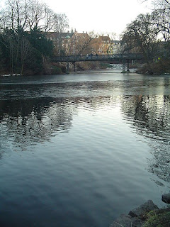
Ørtedsparken (public domain image)
The road is straight, wide and flat; as such, it's unlikely to cause any problems over the 0.73km section leading to the Botanisk Have gardens. Once past the extensive glasshouse, a very slight deviation to the left leads to Copenhagen's oldest cemetery to remain in use, Holmens Kirkegård which contains among many graves belonging to famous occupants that of the artist Heinrich Hansen. At the end, when the lake on the left comes into view, a slight left leads for approximately 48m along Dag Hammarskjolds Allé to a tighter right onto Classensgade (55°41'47.04"N 12°34'49.71"E) - this is another section where diesel spills are a potential hazard. Classensgade, though considerably narrower than Hans Christian Andersen Blvd. or Øster Farimagsgade is nevertheless easily wide enough for a peloton, never mind a single time trialer, along its entire dead straight 0.69km stretch.

A 90 degree left at the end carries the riders out onto the left-hand lane of Strandboulevarden (55°41'57.27"N 12°35'24.74"E) - anyone who attempts to take the corner too fast will be at risk of running straight into the central reservation which, since it has trees, could be a race-ending crash. Also, being another main route with several bus-stops, spilled diesel again poses a risk, as could the several pedestrian crossings along the way as the painted sections can become slippery when wet. With the exception of a very slight kink in the middle just past what was until very recently the Danmarks Designskole (it's since moved and merged with the School of Architecture), the road is straight for 1.18km. It then curves left, with riders again needing to be cautious to avoid the central reservation, and continues for a further 0.42m to a tight right-hander into the left lane of Østerbrogade (55°42'42.67"N 12°34'39.03"E).

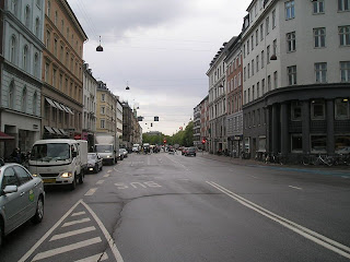
Looking north along Osterbrogade from the Trianglen. The
riders will join the road more than a kilometre further along
(© Leif Jørgensen CC1.2)
As Copenhagen's premier retail location, Østerbrogade has several bus-stops and will receive many truck deliveries each day. It is, as unfortunately tends to be the case with all shopping streets around the world these days, is studded with the usual purveyors of McGreaseburgers - the wrappers of which are surprisingly lethal if caught beneath a a wheel; however, other than the bend at the end leading to the Ryvangs Allé, it's completely straight for the full 0.82km length, reducing the hazard for mush of the section. They follow the road for 1.88km, crossing a fly-over after 1.33km, then arrive at an intersection. Passing through takes them onto Gersonsvej.

After another straight section, this time of 0.87km, the route arrives at another intersection and crosses straight over and into a slight left followed by a gentle right. The road turns straight for 0.24km, then turns a medium-tight right onto Bregnegaardsvej. This leads into a sweeping left 0.14km later, followed by another straight 0.94km heading into the Charlottenlund Slottspark, starting at the Forstbotansk Have (forest park) on the right. The section lasts for approximately 0.49km after the Viggo Rothes Vej, then the riders turn right onto Jægersborg Allé.

Charlottenlund Palace (© Henrik Jessen CC3.0)
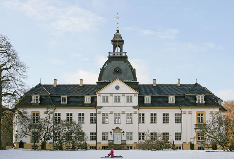
From road level, the first good look at Charlottenlund Palace comes after 0.25km as the road follows a gentle curve left. Named after Charlotte Amalie, sister of Christian VI, it was originally constructed in the Baroque style but remodelled in the French Renaissance style around a decade after it became home to Crown Prince Frederick - later to become Frederick VIII - and his bride Lovisa Josefina Eugenia of Sweden adopted it as their home (Lovisa sounds to have been rather a likable character - permitted to be herself by her remarkably liberal father Charles XV of Sweden rather than being trained to do what she was expected to do, she became a bit of tomboy and got up to all sorts of things that young ladies were not supposed to engage themselves with, for example - shock, horror - swimming. Her mother, though on the whole considering it important to behave as ladies should, was also a fan of the sport and between the two of them they made it a fashionable and acceptable thing for women to do, thus opening the way for women of their time to become involved not just in swimming but a range of other sports too). Though she was, a little surprisingly, very strict with her own children, she had little time for court and formalities; those who met her describing her as being funny, friendly and easy to get along with. She created a number of charities aimed at improving the lives of various groups in society and enjoyed enormous popularity among the public.

Jacobson's influence spread far beyond Denmark. This, his
building for St. Catherine's College, is in Oxford.
 (© Bbacambridge CC2.5)
Charlottenlund, a town in its own right, has become one of the most affluent suburbs of Copenhagen and boasts many mansions and great buildings including several by the notable architect Arne Jacobson in the Danish Modernist style and considered of international importance. Having been influenced whilst still a student by the great Swiss architect Le Corbusier, Jacobson later traveled to Germany where he was exposed to the revolutionary work of Gropius, van der Rohe and the Bauhaus; incorporating their rationalist design philosophy into his own work. In 1929, he won first place in a competition to design the House of the Future, the design then being realised in full scale at the Forum København - which, incidentally, was also home to a six day annual bike race for the first few years of its history. The House was an immediate a enormous success, firmly establishing its designer as the architect to go to for an ultra-modern house. However, his considerable talents didn't stop with architecture - he designed a wide range of furniture including four items that have became among the most iconic of the 20th Century: the Ant, Model 3107, Egg and Swan chairs, all heralded in the 1950s as perfect amalgamations of functionality and aesthetics and - as unlicensed copies at least - still available to this day when Jacobson, who had to flee by rowing boat to Sweden to escape deportation to a concentration camp under the Nazis due to his Jewish roots, is alongside the Finn Alvar Aalto widely considered to be one of the people responsible for forming the overall look of the last century.

Øregård Museum (© Henrik Jessen CC3.0)
After gentle left and right bends potentially made slippery by fallen leaves, the road heads straight for 0.46km until it reaches a 90 degree right turn onto Strandvejen by the Akvarium (55°44'54.56"N 12°35'14.13"E). To the left is Charlottenlund Fort, a coastal battery constructed during the 1880s to protect the northern sea approaches to Copenhagen. The road continues, straight but for a few unchallenging and gentle bends, for 2.6km south to a 90 degree right turn onto Ehlersvej. 1.23km before the turn is the Øregård Museum in the Hellerup district, housing a collection of more than 3000 paintings depicting Copenhagen and its environs and housed in a neoclassical mansion built in the early 19th Century by a rich merchant. Hellerup is also home to the headquarters of Saxobank. To the left as the riders approach the turn is a harbour and huge business park, home to the Tuborg brewery.

0.33km later, they take the easy left turn back onto the Ryvangs Allé, taking the left lane so as to avoid cyclists further down the start list heading in the opposite direction. After 1.3km, they turn probably the most dangerous corner on the parcours, an extremely tight left to enter Svanemøllevej. The road seems unusually wide for a residential street, the reason for this being that it was constructed to relieve heavy traffic on the nearby Strandvejen and, in the past, carried trams as well as cars and time trial bicycles. A very affluent area, each house is unique with some deserving special note: Number 3 was deliberately destroyed by an explosion during the Nazi occupation and was subsequently be a modern villa built in 1961 and Number 14 has a large hidden basement built underneath a normal, unconcealed basement, complete with a tunnel leading to a second section hidden below the garden. It's not known who built it, but it can be reliably dated to the Nazi occupation and evidence suggests it was used to covertly hide Jewish citizens until they could be transported to safety in Sweden. Several others are currently occupied by foreign embassies.

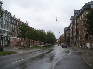
The entrance to Strandboulevarden from Osterbrogade.
Note the trees in the centre - extreme caution will be
required to avoid hitting them if it's as wet as it is in
this photograph (© Leif Jørgensen CC3.0)
Vangehusvej is 0.29km from the corner, with the riders turning right onto it. They then turn right again after 0.11km onto Strandvejen., one of Denmark's oldest roads and which heads in the opposite direction for 38km to Helsingør - better known to we English speakers as Elsinore, site of Hamlet's castle. Reaching the bridge over the railway 0.4km later, the riders pass onto Østerbrogade and once again remain in the left lane so as to avoid oncoming riders, doing the same 0.73km later after the tight right turn into Strandboulevarden.

Having traveled the opposite way around the same bend as earlier, they change after 1.4km to the right lane and join with Kristianiagade as it continues south, then south-west for 0.49km to a tricky left turn by the Østerport Station onto Oslo Plads before passing onto Grønningen. To the left is the 17th Century Kastellet (55°41'30.41"N 12°35'39.76"E), the best-preserved fortified citadel in Northern Europe.

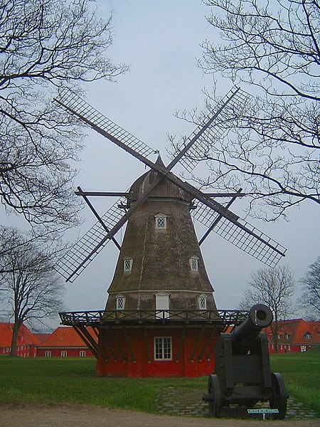
Being higher than the surrounding areas, the
ramparts were the ideal place to position
windmills. This one still stands inside the
Kastellets (CC1.0)
With a history beginning in 1626, during the reign of Christian IV who was unable to realise his full plans for the site when finances ran out, the first noticeable thing about the Kastellet is its striking pentagram shape, not dissimilar to the fort at Briançon we saw right back in July during Stage 18 of the Tour de France, a design intended to to provide 360 degree cover of the surrounding area and to leave no point or corner along the defensive walls unprotected. The second thing that those tourists who are paying attention notice is that the castle reveals Copenhagen was not always the content, happy and democratic place that it is today: the design is carefully laid out so as to be every bit as effective at protecting its occupants from the city as it is at protecting the city from sea-borne attack - all that would be required would be to turn the guns and point them in the opposite direction for any civil unrest to be rapidly quelled long before it could develop into revolution. Building began again under Frederick III (hence the official name Citadellet Frederikshavn), Christian's successor, who employed the notable Dutch military architect Henrik Ruse to develop the site.

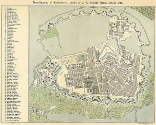
Copenhagen's fortifications in 1728 (public domain image)
Ruse, having seen much active service in a number of different armies, had written a respected book on the subject of fortifications and whilst carrying out research had visited numerous ancient and modern defensive sites throughout Europe; distilling what he observed and learned down into a highly effective new set of techniques. The Kastallet's dual purpose as defender and oppressor was evidently not lost on locals, for Ruse received a number of death threats during his stay in Copenhagen. He was also charged with extending and developing the city's walls, leaving it with some of the most efficient, effective and up-to-date defenses anywhere in the world by the end of the 17th Century. However, military technology moved on rapidly and within less than a century suspicions began to arise that the walls wouldn't be up to the task of protecting against modern warfare. This proved to be the case in 1807 when they proved to be utterly useless in preventing the British - who feared Napoleon might invade Denmark and use the castle and navy to block British access to the Baltic Sea - from bombarding the city, destroying almost a third of its buildings and killing some 2000 civilians. The decision to decommission the fortifications was made in 1842 after two years of studies and deliberations - however, little happened other than attempts to strengthen some sections due to the Schleswig War of 1848. Today, the only remaining parts are the Kastellet and a section lying partially in a public park and partially in the unique Freetown Christiania.

View from the top of the Marmorkirken, across Amalienborg
Slotsplads and towards the Opera House (public domain image)
Having reached the end of Grønningen, the route turns left onto the much narrower Esplanaden ending with a very tight right after 0.22km onto Amaliegade, once the site of the city's General Hospital. After 0.41km, they arrive at Amalienborg Slotsplads, the Palace Square with a palace occupying each of the four corners. Once of Europe's finest public spaces, the Square offers excellent views north-west to the Marmorkirken (Marble Church) and south-east to the modern Opera House - a view the riders will be able to appreciate as they turn left and head in that direction between the easternmost palaces before turning right onto Toldbodgade; a turn that could prove extremely hazardous in the wet due to the slippery stripes of a pedestrian crossing sufficiently wide as to be unavoidable when exiting the Square.

Continuing south-west for 0.46km, the route arrives at Nyhavnsbroen Bridge and crosses onto Holbergsgade before keeping left around a bend 0.18km later to join Cort Adelers Gade as it leads south-west along the edge of the docks. After 0.31m, they arrive at a left turn onto Christian IV's Broen, bringing them onto Slotsholm, originally a a collection of tiny islets and, from 1167, Bishop Absalom's castle; the construction of which is traditionally cited as the beginning of Copenhagen. They then pass under a fly-over onto Christian's Brygge before a right turn 34m later for Slotsholmengade, following the street for 0.28km and turning left into Rigsdagsgarden alongside the Christiansborg Palace shortly before it becomes Tøjhusgade (55°40'34.05"N 12°34'51.39"E).

Christiansborg Palace, built on the site of Bishop
Absalom's castle (© Eimoberg CC2.0)
The Palace houses the Folketing (pariament), Prime Minister's office and Supreme Court, thus making it the only building in the world to house all three branches of government (executive, legislative and judicial). The current building dates from the early 20th Century; having been constructed on the site of an earlier palace begun in 1803 - when completed 25 years later, King Frederick VI decided it wasn't up to his exacting standards and declined to move in, using it solely for entertaining guests. His successor, Frederick VII, lived in the palace for 11 years, leaving in 1863. 21 years later, all but a few sections were destroyed by fire. Prior to 1803, the same site was occupied by the original Palace; upon which construction began in 1733 - it too was eventually destroyed by fire just 61 years later. Before the first Palace, Copenhagen Castle stood here; as it had done since a few years after the original occupant, Absalom's castle, was destroyed at the hands of the Hanseatic League in 1369. Remodeled and modernised in the 1720s by Frederick VI, bad engineering meant that the newly-strengthened walls cracked under their own weight; leading to demolition in 1731 to free up space for the first Palace. Remains of Absalom's castle were unearthed during excavation work to create the foundations of the new Palace and are open to the public.

Having come to the end of Tøjhusgade, the riders cross Prinsens Broen and enter Ny Kongensgade; crossing Vester Voldgade and arriving at Hans Christian Andersen Blvd. after 0.26km. They turn right, once again taking care to avoid diesel patches, then enter the final section to the finish line at the City Hall 23.2km from the start.

Monday 19 September 2011

Copenhagen UCI World Road Racing Championships


This is what the future will look like; or what the
present already looks like if you're lucky enough
to live in Copenhagen. The Bryggebroen was the
first bridge to span the city's harbour for 150 years
and is reserved for cyclists and pedestrians.
(© Stig Nygaard CC2.0)
Copenhagen is, without even the shadow of a doubt, a very fine place indeed to be a cyclist. It was the UCI's first official Bike City and achieved third place in a list of the 11 Most Cycling-Friendly Cities in the World in 2009. An estimated 36% of the population cycle to work, clocking up a seriously impressive 1.1 million kilometres each day between them - and the municipality aims to increase that percentage to 50% in the next three years. It's even given rise to a new verb used by architects and town planners: to copenhagenise means to create a cycling infrastructure including dedicated cycle paths, bike lanes, public bike programs, secure parking and even public access maintenance facilities, and it's become widely recognised as a sure-fire way to improve the urban landscape and the quality of life enjoyed by citizens.

Vejrpigen
(© Archer10 CC2.0)
If there's one thing guaranteed to get more people on bikes, it's a large-scale, well-run bike race; so it's a safe bet that the city would have been overjoyed when it was picked to be the host of the 2011 UCI Road Race World Championships - and that they'll have really pushed the boat out in getting prepared, ensuring one of the best events in years. All races - time trials and road races alike - will start at the spectacular Rådhuspladsen, the City Hall Square where they'll be overseen by someone who ought to know a thing or two about cycling: the Vejrpigen, the Weathergirl, is a mechanised sculpture high up in the Richshuset tower. Ever since 1936, she's come out with her umbrella and dog if it's going to rain and her gilded bike when it'll be fine.

By tradition, Copenhagen is said to have begun life in 1167 when royal advisor Bishop Absalom built a castle on the island of Slotsholmen, nowadays home to the Christiansborg Palace where the castle's remains can be seen preserved in subterranean excavations. However, archaeological evidence has shown that there was already a sizable town here at that time. Once the castle was built, the town was in an ideal position to take advantage of the excellent natural harbour - indeed, the name Copenhagen is derived from the medieval Danish word Køpmannæhafn, meaning merchant's harbour - and begin to grow into a city, receiving a royal charter in 1254.

Rådhuspladsen - the start of all this year's races
(© Karri Huhtanen CC2.0)
After the Second World War - during which the Danes refused to co-operate with Nazi policy, despite being occupied by them - Copenhagen continued to grow and began transformation into the modern city that it is today, occupying numerous natural and man-made islands and combining traditional Scandinavian architecture with the strikingly modern. Now that the harbour's importance has declined, the city has looked to tourism to form an important part of the economy; becoming one of the top destinations for European tourists and especially attractive to the sort of young tourists who go to Amsterdam, Reykjavik and Barcelona. This, combined with the city's deep love and respect for the bicycle, adds up to one thing - this year's World Championships are set to be one of the most spectacular cycling events in years.

Boom!

Lars Boom, overall winner of the 2011 Tour of Britain, leads the peloton around the first
corner in Stage 7, Bury St. Edmunds

Sunday 18 September 2011

EXCLUSIVE! How Andy will win the Tour

Spyclopunk strikes again! Once again, our crack team of undercover investigative reporters has been involved in a covert mission as we attempt to bring YOU, our esteemed readership, exclusive and ground-breaking news from the murky world of professional cycling.

Recently, we revealed the amazing new Cervelo InvisiBike with which the Garmin-Cervelo team hope to win the 2012 Tour de France.

Today, with LeopardTrek on the brink of joining forces with RadioShack to form the new RadioSchleckTrekNissanCyclingShackProfessionalLeopardRacing Team, we can exclusively reveal the tactics with which team boss Johan Bruyneel aims to propel his new star Andy "What's a nice boy like you doing in a peloton like this?" Schleck to Tour victory.

Creeping round the back of the hospitality tent at the Tour of Britain to slide a camera under the walls for a sneaky shot of the podium girls' knickers, ace reporter Ian Twitchie-Forrts overheard the Belgian ex-pro holding a whispered discussion with an unknown character who we've since decided was almost certainly John Burke, president of the Trek Bicycle Corporation on the strength of little else than A; it sounded like a man's voice, B; Burke is a man and C; Twitchie-Forrts learned his trade at News International and doesn't see why shoddy journalism should get in the way of a good story.

A highly-skilled master of stealth and disguise, ace reporter
Ian Twitchie-Forrt can move around undetected anywhere
he chooses. That's how Cyclopunk brings you news stories
you won't find anywhere else.
Hearing the words "Andy," "Tour," "TT," "Fabian," "new bike" and "race," Ian's finely-honed reporter's mind told him that he might just have stumbled on the story of the decade - especially if he filled in the gaps with "won't win the," "because he's not very good at," "so with," "doing all the work at the front of the" and "while Andy and Frank chill out at the back and think about kittens and stuff, we'll thrash every other team in the." You may think this sounds like conjecture, but Ian's cv says he's really good at this sort of thing and that's good enough for us.

Realising, as journalists say, that a scoop of this magnitude would fill several thousand sewage works and earn him such gratitude from Cyclopunk editors that they might even stretch as far as to buy him a can of Special Brew, Ian withdrew his camera and another piece of equipment he prefers not to specify; then went off on a prowl around the team compound to see what he could find. He struck gold at the LeopardTrek bus, having taken some time to find it due to originally mistaking it for a spacecraft.

"Basically, I rigged up a quick disguise and sneaked round the side of it," he says, "and let me tell you, I was bricking it in case they had any pitbulls or Jens Voigt on guard. They didn't, though, and so I was able stick my head in through the bus's emergency exit at the back - and, well, I couldn't believe my eyes."

"Nearly four weeks I've been in this business, but never have I seen anything quite like the bike they had hidden away on that bus," he continues. "It was like something from another planet. When these pictures get out the UCI are probably going to go mad because all the other teams will just give up and not even bother applying for the Tour. Later in the day, as they were loading up the pasta, they actually took the bike off the bus for a minute or so and that's when I managed to get a photograph."


Our resident expert Neil Droznan spent last night examining the photographs and has come up with an explanation of what Bruyneel is planning.

"It's a simple matter really," he says. "as well know, drafting is permitted in team time trials. Cancellara, as we all know, is the best time trialist in the world and the air gets out of Voigt's way in case he hurts it. The only trouble is, whereas Andy and Frank can climb a mountain like a goat on amphetamines, they're well-known for not being that good at anything else - well, except embroidery and flower-arranging. As a result, they're just not quick enough on a TT course to draft behind Fabian and Jens."

"Having also taken a close look at the UCI time trial rules, I've been able to discover that at no point does it mention six-seater bicycles or whether or not they're permitted in competition," he adds. "So what Bruyneel plans to do, obviously, is stick Voigt on the front to frighten the laws of physics out of the way; Cancellara behind him to act as the engine; bung Posthuma, Gerdemann or whoever in the middle to make up numbers and then stick the Schleck boys at the back so they don't slow the team down and get a bit of a kip so they're all rested and ready for the steep stuff.

We rang Bruyneel at his lair in a mountaintop castle in the Belgian Alps, hinting that we know what he's up to - at that time he refused to comment other than cackling darkly. However, he phoned us back this morning and told us to look outside. We subsequently did so, but can't see anything different out there.

Since we have better things to do, would one of our readers be so kind as to keep an eye on this live webcam feed and alert us if you notice anything?
Creative Commons License
(Does not apply to images attributed to other authors/owners)