Wednesday 7 September 2011

Tour of Britain - Stage 1 Guide

Bridge over the Tweed, Peebles (CC3.0)

One of the many wonderful things about the Tour of Britain is that the organisers allow fans to download the full route details, which you can do so by clicking the relevant link above and thus - if you happen to be a really obsessive fan - follow the action in centimetre-by-centimetre detail. However, road books are primarily compiled with the interests of the riders themselves in mind and thus don't include details on interesting sights and locations along the route, which is why we'll be producing the same in-depth stage guides for this race as we did for the Tour de France and Vuelta a Espana; along with mentioning any points which appear potentially hazardous to our eyes and instincts that we feel the organisers may have missed. In addition, we'll be providing updates on our predictions for race success, comments on riders and incidents and weather conditions.

Monument to the men of Peebles who gave
their lives in the First World War
Stage 1 of the 2011 Tour begins on the High Street in Peebles, Scotland, at approximately 10:15 on the 11th of September. Like many towns in Scotland, Peebles is in touch with its ancient past - the name is thought to derive from the word pebyll, meaning tents and presumably denoting a temporary settlement used by nomadic people, in the Brythonic language (which still exists in the form of Welsh/y Gymraeg, Breton/Brezhoneg and the revived Cornish language Kernowek) that is believed spoken by the Pictish people living here log before arrival of the Gaels, chiefly from Ireland, who would amalgamate with the Picts and thus give rise to the Scottish and the development of the Scots Gaelic language. These pre-Christian roots are plainly seen in the town's annual Beltane celebrations, a festival which in Celtic times involved assorted rituals intended to ensure the fertility of both the populace and the land and to repel harmful spirits. The practice of lighting Beltane fires appears to have survived without interval only in one or two parts of Ireland, but with the rise of neo-paganism and modern interest in Celtic mythology, Beltane festivities now take place in many parts of Ireland, Scotland, Wales and other Celtic nations. In Peebles, these celebrations involved the appointment of a Beltane Queen, these days a girl chosen from one of the town's primary schools, who is crowned among her courtiers on the steps of the parish church - since old churches were frequently erected on the site of much older, pre-Christian places of worship, there's a reasonable possibility that the ceremony has been taking place in the same location for much longer than the church has stood.

The Old Parish Church, Peebles
Peebles became a Royal Burgh in 1152, during the reign of David I, thus giving it the right to representation in the Scottish parliament and to trade autonomously. This led to the establishment of a profitable market, attracting traders from a wide area and ensuring the town's relative wealth. From the Industrial Revolution right up until the latter half of the 20th Century, the woolen industry became hugely important to the town's economy and it was home to several mills, of which one still survives. From the middle of the 19th Century it also became a centre of health tourism based on the spa treatments made possible by the mineral water springs in the area. One spa survives, but most of the others have since been converted into hotels accommodating the many tourists who visit Peebles each year.

The wide, handsome High Street is lined with imposing buildings dating from various centuries, many of them occupied by shops selling shoes - the town has the highest number of shoe shops per capita in the United Kingdom - where the peloton will set out towards the Old Parish Church which, with construction beginning in 1885, is not quite as old as the name and Gothic styling suggests - the tower of St. Andrew's, standing alone in a graveyard since the church attached to it was ruined and its masonry recycled for use elsewhere, is far older. Arriving at a T-junction with a mini-roundabout around 130m after setting off, they turn right onto the A-72 and follow the road into Old Town and then the third turn on the right for Young Street, becoming Rossetta Street before another right turn onto March Street. Match Street narrows slightly towards the end, but not enough to cause problems unless anyone's still asleep and rides into the kerb which can be seen jutting into the road. A tight right turn at the end leads along the A703 Edinburgh Road which runs straight for 0.55km to a junction with the A72 Innerleithen Road.
Innerleithen: St. Ronan's Wells
Having ridden 4.6km, the peloton arrive at the end of the neutral zone by a left turning onto a road leading to Glentress - home of a mountain biking centre with trails including the famous Spooky Woods and Ewok's Village (a North Shore-style freeride trail with elevated tracks, see-saws and so on), considered some of the best trails in the world. The route passes by, into a sweeping right/left bend leading into a 1.72km straight section ending in a slightly technical right bend with an easy entrance, straight ascending middle section and kinked exit - however. the short climb at the end of the preceding straight should reduce speeds sufficiently to prevent problems. Another straight section follows along the banks of the river, ending at a wide left bend  leading into a 2.1km straight and another wide left around a hill topped by the remains of an Iron Age fort and heads into Innerleithen, 6.2km from the start. Almost immediately after entering the town, the route turns a very sharp right onto the B709 and reaches the first of three intermediate sprint at 7.2km, beginning by the cemetery gates.

Innerleithen is home to St. Ronan's Border Games, established in the middle of the 19th Century and today the oldest organised sporting event in Scotland and world class mountain bike trails, including a downhill course said to  be especially challenging by those who do that sort of thing, forming part of the famous "7 Stanes" trails along with Glentress. The road narrows considerably as it passes across a bridge over the River Tweed, leading to potential problems if high speeds from the sprint create a bottleneck with several riders attempting to squeeze through together - the road remains narrow on the other side. 

Traquair House, oldest continually inhabited house in
Scotland.
A tight right-hand bend lies 329m from the bridge, surrounded by trees and thus likely to be slippery if recent wind and rain have blown leaves onto the road (and since this is Scotland, they probably have done), before a 1km section starting with trees on the right of the road concealing Traquair House, believed to date from the 12th Cetury (though no surviving part can be dated before the 15th) and as such claimed to the oldest continually inhabited house in Scotland. Frequently used as an example of Scottish Baronial architecture, the House in fact predates the style and was a probable inspiration for it. The famous Bear Gates were closed in 1745 and have remained shut ever since, only to be reopened when a Stuart once again sits on the Scottish throne.

The B7062 becomes the B709 on the other side of a crossroads in the village, a road the race follows for the next 11.4km. The peloton climb as pass through Kirkhouse, reaching 200m just to the south between two farms. There's an easy left followed by a tight right 1.19km from the second farm before the road reaches 300m alongside a conifer plantation, climbing to approximately 360m before beginning to descend as we leave the plantation behind and travels across open moorland, passing by two ring-shaped enclosures 0.96km apart - it's impossible to say what they are from aerial photographs but they look to be of some antiquity. There are also two cattle grids - extremely hazardous unless hit at an angle very close to 90 degrees to the poles - located at 16 and 18.7km. After 20.5km, the route reaches a crossroads south-west of Montbenger and turns right at the Gordon Arms Hotel onto the A708 (there's an antique petrol pump set up in the carpark next to the hotel, if that sort of thing interests you). The road is straight and level all the way to St. Mary's Lake, following along the northern shore and arriving at Cappercleuch after 27.2km and a right turn onto a narrow unclassified road 160m after the orange "rumble strip" traffic-calming device immediately west of the village. It's an innocuous-looking road, but not without danger - 35-year-old David Stanners of Peebles CC was killed here after misjudging a bend and crashing into a wall on the 3rd of September 2011, just eight days before the Tour passes through. There are a further three cattle grids located at 30.2km, 35.9km and 38km, with the first climb of the race - Cat 3 Megget Hill - beginning at the third shortly after passing through Meggethead. The summit lies 0.4km after the start of the climb. There's a very steep descent - hazardous at 20% - 1km after the summit, the high speeds generated by it making a  sharp right-hand bend 0.8km later hazardous.

Tweedsmuir Parish Church (CC2.0)
The route turns north towards Talla Reservoir, the construction of which swelled the local churchyard for over 30 men - mostly Irish cheap imported labour - were killed whilst it was being built. Having passed along the edge of the water for around 1.63km, the road narrows slightly as it crosses a bridge. 2km later, the peloton turn a tight 90 degree left (by trees, hence possibly slippery) to pass along the dam, hitting an equally sharp right-hander 0.3km later. This road leads us to Tweedsmuir and a T-junction with A701, where the race turns left to head south-west. A short way away on the same road is the Crook Inn, made famous as the place where Rabbie Burns penned his poem Willie Wastle's Wife - not his best and somewhat questionable to modern tastes as it basically concludes Mrs. Wastle to be worthless as a human being due to her physical unattractiveness - and one of the many claimants to Oldest Pub in Scotland (there are many oldest pubs in Great Britain's constituent nations - I have personally been to four Oldest Pubs in England). 3.1km later, the race reaches the first drinks station - always a potential hazard as riders slow and grab the bidons (drinks bottles) held out to them by team employees. The next Cat 3 climb begins at 55km.

The Devil's Beef Tub (CC2.0)
The summit comes 4.5km later near the Devil's Beef Tub, a 150m deep hollow between four hills described by Sir Walter Scott as "a damned deep, black, blackguard-looking abyss of a hole" (it's actually quite attractive). The name comes from the hollow's use by the Johnstone clan, described by the farmers in the area upon whom they preyed  as devils, as a place to hide stolen cattle. The descent into Moffat, 70.1km from the start of the race, is undemanding in the dry; though as ever on a descent unpredictable factors such as punctures can rapidly become disastrous.

Moffat has been a tourist destination ever since the 17th Century when health benefits were first ascribed to the sulphurous waters that bubble up in the area - during the height of the spa's popularity, a special pipeline was built to carry the water from a well on the hills down to a bath house in the town and several hotels sprang up - one, The Star, was listed in the Guinness Book of Records as the narrowest hotel in the world at just 6m wide. The stage's second intermediate sprint begins at Moffat's town hall, housed in the old bath house on the A701 running west of the High Street. Reaching a short road connecting the two, the peloton turns a tight 90 degree left and right - this being in the middle of the town, there's the potential for diesel and puncture hazards on the road - heading out of town along the High Street and, having negotiated the tight left bend at the end, on the A708. After half a kilometre, the race turns right onto the Old Carlisle Road. Following the undemanding road until 80.1km leads to a junction and a sharp right into Newton. They pass over two bridges, one crossing a river and one a motorway, then turn left onto the B7076. The 1km long feed zone - another hazard as riders slow down and grab musettes (cloth bags filled with energy gel and the various things professional cyclists have to eat), domestiques loading up and ferrying the bags back to their teams.

The route remains level and straight until it reaches Johnstonebridge where the peloton turn a sharp right into the village which marks the approximate halfway point of the stage. At the next junction, they turn left and past a farm, riding through a small wood as the road climbs slightly before a short descent towards a difficult left-hand bend in woodland, caution being required in case of slippery leaves on the road and possibility of punctures. There's a very short but steep climb in the woods before the road begins to descend on the way out towards the crossroads, which the race travels straight across to arrive at a T-junction 0.39km later. They turn right here, heading towards St. Ann's, then a wide left bend takes the race through 180 degrees onto the A701 continuing through Parkgate at 98.5km, Amisfield, Locharbriggs and into Dumfries.

The Old Bridge, known to locals as Auld Brig, Dumfries (CC3.0)
Dumfries, the largest town we've yet seen on this stage. Like Peebles a Royal Burgh until the distinction was abolished, Dumfries was the site where in 1264 King Alexander III met with his knights to plan an invasion of the Isle of Man, once under Scottish rule but controlled by the Norwegian monarchy for almost two centuries. William Wallace and his rebels passed through in the latter years of the same century, chasing an English army who applied for protection at the now vanished Dumfries Castle but were refused, eventually being caught and slaughtered at Cockpool some kilometres to the south on the Solway Firth coast. The town has a long and bloody history - not only was it the scene of several vicious attacks and lootings at the hands of the English, it also executed ten "witches," the unfortunate women being tied to stakes and strangled before their bodies were burned. As late as 1868, it was the site of the last public hanging to take place in Scotland. Strangely, it has experienced two earthquakes on Boxing Day - one in 1979 and another in 2006. Its police force is the smallest in Scotland, but played a large role in one of the largest criminal investigations ever to take place - that following the bombing of Pan-Am 103 which fell on the nearby town of Lockerbie.

Remaining on the A701 through the town, the race takes the second exit of the first roundabout onto Edinburgh Road, doing the same at two more roundabouts until the road becomes Academy Street before negotiating Church Crescent and turning left before the bridge onto White Sands which, later on, will host the finish line of the stage. As the peloton crosses it. 0.5km from the corner, they begin the third intermediate sprint. Reaching the end of the road, the riders turn a sharp right onto St.Michael's Bridge leading to St. Micheal's Bridge Road becoming Pleasance Avenue. This leads them to a T-junction with the A710 where they turn left to head south towards the Solway Firth. 2.24km ahead, they reach a tight 90 degree right corner followed by an equally tight 90 degree left 0.38km later on the way through Islesteps. Another tight left lies 2.63km away; followed by a medium left bend left, tight 90 degree right and hump-backed bridge at New Abbey, with a medium left on the way out for good measure. New Abbey is the site of the not-very-new, ruined and delightfully named Sweetheart Abbey, founded in 1273 by Dervorguilla of Galloway in memory of her husband John Balliol, himself the founder of Balliol College at Oxford University.

The Solway Firth served as a backdrop to the fictional
Summerisle in the 1973 film The Wicker Man (CC2.0)
The road climbs and then descends gently over the next 7.8km to Kirkbean, the route consisting of long straights with no challenging bends. The village was the birthplace in 1747 of John Paul Jones who went on to found the United States Navy. In days gone by, thousands of people seeking a better life in America passed through here before setting sail on the ships that sailed from the inlet formed by the River Nith's estuary on the Solway Firth just to the east, but today it's a quiet place given over to nature. A nature reserve on the far bank is an important breeding place for several species of birds. The race continues through on the same road, reaching Caulkerbush and a slight left before taking a tight right 54m later onto the B793. The Cat 3 climb of Banks Hill begins 0.95km after the turning as the peloton pass a large house to the right of the road, just past a junction. It ends 1.5km later along the straight road, in between farm gates on the left and right,, almost precisely 140km from the start of the race.

Beeswing Kirk - a church converted
into a private home (CC2.0)
A medium left some distance ahead sees the road begin to descend again before arriving at a T-junction, turning an easy right before continuing to Edingham, site of an industrial complex and hence another potential spot for diesel spills. There are some large circular earthworks just right of the road as it passes the turn for the complex before arriving at a T-junction with the A711 where the peloton turn right. The road remains wide and unchallenging for 9km with exception of a slight climb towards the village of Beeswing.

Anywhere with a name such as Beeswing very obviously deserves a closer look - and an explanation of the strange name. Originally named Lochend, the village elected to rename itself after a famous thoroughbred mare, winner of 51 races during her short eleven-year life. The horse was neither from here nor ever visited, an indication of the high esteem in which she was held. There's a very steep descent 1.56km past Lochanhead, the road dropping more than 60m in around 0.7km, followed by a slight rise into Cargenbridge before the race reaches Dumfries 1.2km later. Having passes straight across two roundabouts and along Cassalands and Galloway Street, the peloton arrives at a bridge, crossing the river and turning a sharp left to enter White Sands. Following a final 300m sprint, the stage ends after traveling 170.3km from the start line.

Predictions: Now, we could be wrong because he'd plainly have far rather been at the Vuelta a Espana, but we can't see any reason why Thor Hushovd won't win this one easily. However, strange things happen in these smaller Tours - while the bog boys are all tuned to the three week Grand Tours, the lesser-known lads will go hell for leather caring not in the slightest if the quest for glory leads to an early burn-out.

Weather: Wet - and very wet. Rain is expected across many parts of Britain tomorrow, with the heaviest of all predicted for Western Scotland. That ought to be a fun start. Wind is a little tricky to predict at the moment due to Hurricane Katia lurking off Newfoundland over on the opposite side of the Atlantic - very strong wind is expected for the area in the next few days, but at present it looks as though it won't get too rough until Sunday night or Monday. The maximum temperature might climb to 18C, but probably not: 14 or 15C is more likely.

Vuelta a España - Stage 18 Preview

Stage Map: click here
Stage Profile: click here
More Previews: click here

The high mountains are all ridden, but there's still plenty of climbing to be done in the 2011 Vuelta - a fair bit of it in today's Stage 18 with a total of 2110m of categorised ascending and plenty of extra uncategorised climbs to make sure everyone knows they've been working hard.

The people of Solares have evidently been hard at work praising the gods of cycling this year - they've been doubly blessed. Not only did they get to see an intermediate sprint on their streets yesterday, they also get to be the start town today.

With its light, airy buildings and wide avenues, Solares looks every inch the modern town: it could easily have been designed from scratch by a philanthropist architect in the 20th Century as an example of an ideal Utopian community, but this is as a result of good management - it's in fact much older, as proved by the existence of the early medieval period Pico Castillo, assorted private houses dating from the 12th Century, the 17th Century Palacio de los Marqueses de Valbuena and the vast early 19th Century spa, restored and modernised in recent years to form an up-to-date resort.

Juan Antonio de Saro y Galban
The stage begins at the bus station on the Calle de Calvo Sotelo before moving down the Av. de Oviedo and passing the Calle de los Mies del Corro. It's a short neutral zone today, ending after just 3km on the N-634 near San Vitores. The route passes La Herran and El Condado along the wide, unchallenging road before reaching Elguero after 5.3km, carrying on straight ahead a little way further on as it's joined by the A-8. After 9.5km, the race reaches Sarón and passes right through the town and under the A-8 to La Penilla. Sarón, like Solares, looks like a modern town - but in this case, it really is: the oldest structure here, built by Juan Antonio de Saro y Galbán, dates from 1876. Curiously, the town's name comes from de Saro's nickname - Sarón being a name apparently applied to tall men with beards in this part of the world.

A roundabout in the middle of La Penilla shouldn't cause problems as the peloton won't turn here, but it's slightly off the centreline of the entering and exiting roads and thus could conceivably clip the wheels of any rider either not quite awake yet of pushed onto it by the sheer weight of numbers still making up the pack at this early stage in the race. The next village, La Cueva, derives its name not from a cavern but from the Latin name of the Roman road that connected the Bay of Santander to the iron ore mines of Peña Cabarga. To leave the village, the route turns left and then right to get onto the N-634a leading to Villabáñez after 17.7km, passing by the beautiful Colegiata de la Santa Cruz at Socobio. There are five speed humps along the road traveling through, then easily the ugliest bridge we've seen so far in this year's Vuelta carries over the river and into Vargas. An very tight left at the roundabout in the middle of town leads south-east along the N-623, following the river for a while as it winds its way through the green landscape, then arrives at Puente Viesgo 22km from the start. This beautiful little town with a very fine church stands on a stretch of river that, with its white water rushing between rocks, surpasses everything man-made along its banks. We pass by one bridge, the Gran Hotel and a second bridge before leaving the town and continuing onward to Aes, negotiating a roundabout halfway between the two communities.

Entrambasmestas
The parcours continues sourth-east, through Corvera and past Cillero, Borlena, Villegar and San Vicente de Toranzo (appearing on some maps as Corvera de Toranzo) before arriving at Ontaneda. Despite appearing quite larger, it's a small community stretched out along the road and contiguous with Alceda, but rarely goes back more than three houses from the road. Prior to the 19th Century, Ontaneda was frequently known as el Corralón de Alceda, "Alceda's Yard," but today is has far outgrown its diminutive parent. La Escobosa is reached and passed, then we arrive at Entrambasmestas, nestling at the foot of a forested hill and with its narrow streets, little houses and square complete with pavement cafe perhaps the perfect embodiment of a little Cantabrian village. As the race arrives at the village, the route turns sharply to the left then bends right as it changes onto the CA-263 heading along the edge of the forest - thus making it potentially slippery - and past picturesque Candolias and onward to Vega de Pas, the capital town of the municipality and, with 311 inhabitants, its largest. The race turns left, heading into the village and around some tight corners to join the CA-262 and crossing a narrow bridge on the edge of town with 50.3km ridden; marking the beginning of the Category 3 Puerto de Braguia climb which will carry the peloton to 725m above sea level after ascending 365m in 5.9km.
Cantabria
A hairpin lies approximately 100m from the bridge, not especially steep by quite tight, and a second with much the same description coming after 0.89km. A fairly tight left bend leads up to a series of relatively unchallenging bends after 0.6km, then two wide bends - the first traveling around a ruined house - and a 90 degree right lead into a gently curved section of 1.4km and another 90 degree right taking us up to a forest. The road twists as it follows the contours at the forest's edge, reaching the highest point as it rounds the second bend.

The initial part of the descent is fast and, with fairly gentle curves, not too technical. However, it reaches hairpins very soon; the first arriving 1km after the forest is left behind and the second 0.4km futher on. Neither are especially steep, but both are tight with the second being the more difficult of the two and bending through more than 180 degrees before straightening out. A very tight left, around 100 degrees, lies 0.2km ahead; then there are 1.4km of gentle curves and fast descending to the next hairpins. The first is easy; the second drops 14m and is very tight - and is surrounded by trees, making it potentially slippery and very hazardous indeed: if it's raining or has rained in the past few hours, crashes can be virtually guaranteed at this point. One final hairpin comes after another 1.5km of high-speed downhilling - this one is much less steep than the last, but is tight and again surrounded by trees. Combine these factors with the high speeds at which riders will enter the section and crashes are very likely here too. There's a tight left after 0.3km, then we approach Selaya along a road almost perfectly straight with the exception of a slight left and a 45 degree right as we enter the town.

Selaya
Selaya, 64.3km from the start, is famous for its cubos del término municipal y rollo heráldico, 17th and 18th carved stone pillars acting as a combination of shrine, container for heraldic rolls and boundary marker. Having entered the village across the wide bridge, the race turns right onto the CA-264 and immediately begins the second climb, 840m Cat 2 Alto del Caracol featuring 600m of climbing in 10.8km. The first section of the road, though fairly steep, is unchallenging and the race should reach the small descent at 67km from the start very rapidly. The first hairpin - wide and not technical - comes immediately afterwards as the road begins to climb the main part of the mountain. A few bends through patches of trees could prove hazardous if conditions are wet, but will probable be problem-free. A wide left-hand bend leads into a gently twisting section of around 2.95km in length, climbing quite steeply up to 600m just before the next - also unchallenging - hairpin. A tight right-hand bend lies 0.4km ahead, then another gently twisting section rises to 700m and enters a 0.3km straight leading to the next hairpin, wide but - climbing 14m - steep. The next, 0.2km away, is much less steep and equally wide. Two left/right Z-bends, the first gentle and the second much tighter come within 0.25km of one another, the altitude reaching 800m just as we enter the second. The summit comes just as the race passes by a house standing alone on the left of the road and before reaching a rocky outcrop to the right. The descent is fast with a potential hazard coming just half a kilometre after the outcrop at a place where dirt tracks join the road, leading to dust, mud and grit on the road surface. Two tight left-hand bands lie a short way ahead, followed by the first descending hairpin which - coming after a steep section, being surrounded by trees and dropping 10m - is another potential hazard. Following 90 degree right/left/right/right turns in quick sucession, the race reaches a junction with the CA-260, turning through a tight 180 degrees to join it and ride into San Roque de Riomiera. The road turns a medium right followed by a medium left and another medium right as is passes through the town, arriving at a right-hand hairpin just around the following gentle left bend - it's a descending one, surrounded by trees in what looks to be a damp or even marshy area and as such is very likely to be slippery. A second and equally tight left hairpin lies 0.15km ahead, surrounded by trees once again but less steep and likely to be approached at a much slower speed. There is a narrow bridge 2.1km from the village and a sharp right turn to continue on the CA-260, the road ahead becoming the CA-642.

The route passes by the high, mountainous landscape to the east and travels by Ajanedo - site of the Cueva de El Salitre, a cave with paintings dating from the Upper Palaeolithic, a period lasting between 30,000 and 11,000 years before the present. The road ahead through a gorge, as the CA-641 joins from the left, may seem familiar - it's the same section with ten hairpins in half a kilometre that we passed by yesterday. The road joins the route which enters a deep gorge leading to Mirones and through another - perhaps even more impressive due to the greater height of the cliffs either side - gorge, and reaches Mortesante 185.5km from the start. A 90 degree left comes a little later, followed by straight sections towards Rubalcaba. A 90 degree left comes a little later, followed by straight sections towards Rubalcaba - a little village made famous by the la Casa de Miera-Rubalcaba, a house declared to be of Interés Cultural - Cultural Interest - in 1994. The road into Liérganes, a short way ahead, is extremely narrow en route for the centre of the village, potentially causing a pile-up and crashes, but then opens up again before leaving and heading towards a roundabout. The peloton turn right here onto a route that the road book says is the CA-640 but our maps call the CA-651, heading into Hermosa and including a hairpin along the way. There's a series of tricky bends on the way through the village, then the route straightens out as it approaches Valdecilla.

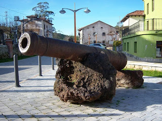
A cannon, cast in La Cavada, mounted on two pedestals
formed from blast furnace slag in the town's Parque de
Carlos III
When the peloton arrive, they turn left to pass along the Calle de Ramón Pelayo leading through Valdecilla and ending at the N-634a. They turn right and proceed to the Av. de Alisas as it becomes the CA-161, then pass through Ceceñas and come to a level crossing 3km after Solares. A right turn carries them south to La Cavada. The town, today home to just over a thousand people, grew up around an artillery factory established here in 1622 - prior to the factory's demise in the early half of the 19th Century, the town rang to the noise and choked on the fumes of four blast furnaces. Once the factory had closed, the locals - finding themselves without a source of income now that the locale's largest employer had vanished, looted the buildings for anything that could be sold or used to patch up their homes. Less than fifty years later, virtually no trace of the facility was left above ground. An old textile mill, built in 1847, may look familiar to some British viewers - it was designed to closely emulate those in Manchester with its large windows letting in plenty of light for the workers to see in the days before electricity was installed.

Panoramic view of Puerto Ailsas
One on the other side of town, the race passes along an almost perfectly straight section of 3.22km before arriving at Riotuerto and turning twistier as the Cat 1 ascent of Puerto de Alisas, featuring a 600m climb in 8.6km, gets under way. A 90 degree right among trees 0.3km from Riotuerto may prove hazardous if conditions are wet but should otherwise cause no issues. A wide right-hander follows around half a kilometre later followed by another 1.25km ahead at the foot of the rocky promontory to the left of the road. The first hairpin, a right, comes 1.9km later and is followed by a medium left bend bringing the altitude to 400m. Another 90 degree right just beyond the rocks leads into a medium left, followed by a straight half-kilometre to another hairpin. This one, a left, rises approximately 11m but isn't especially steep. The next, 0.4km ahead, climbs only 6m but is much tighter. Another 0.4km brings the race to La Calzadillas and 500m altitude, then we arrive at a very tight but not steep hairpin having traveled the same distance once again. A wider one lies 0.2km ahead and is followed 0.33km later by another, much tighter, leading into a sweeping 180 degree right-hand bend followed by a 90 degree right up to buildings. A line of trees conceals the layout of a right/left Z-bend, but it's not a technical one and shouldn't create problems. The next hairpin, 0.2km ahead, is medium tightness and not steep, then a straight 0.3km leads to a sharp right and left by farm buildings. The summit, 675m above sea level, lies just around the left bend by a little car-park/look-out offering views over the green hills to the Bay of Santander.

Iglesia Ruperstre de San Juan
The first 0.4km of descent is relatively flat but leads into a sharp right bend after which the road becomes steeper. An equally sharp left just ahead leads into a section with several bends, potentially hazardous, then a 90 degree right precedes a slight left/sweeping right bend into a tight right hairpin at the top of a very steep slope. A medium left just beyond carries the peloton onto a short straight coming to the next hairpin, a left-hander dropping around 8m. A sweeping right leads to a tight left 0.47km ahead, then 1.76 straight kilometres pass by before the next technical bend, a 90 degree right followed by another easy 1.5km. Two bends, medium tightness but at the foot of steep forested slopes, may prove hazardous due to grit, mud, or leaves on the surface; as might the tight right hairpin just after the second bend. The next, 0.5km further on, is in open country and should be simple, then the road flattens out considerably for the final stretch into Arredondo. Just out of sight around the high, rocky promontory south of the village is Socueva - the site of the remarkable Iglesia Rupestre de San Juan, a church built into a limestone cave during the early Middle Ages. Abandoned for many centuries following the decline of Moorish Spain, it's an eerie place today. Excavations in the cave have revealed that it's been used by humans for much longer than the church has been here, artifacts discovered here have been dated to the Palaeolithic period.

Having passed through the centre of Arredondo, the route rounds a medium left and 90 degree right on the edge of the town followed by a second medium left leading onto a straight section running along the perimeter of a forest. A medium right - potentially hazardous due to the trees - comes after 1.4km; then a medium right enters a poker straight section into Riba. The intermediate sprint begins here with 134.3km ridden since the end of the neutral zone, then the peloton turn a 90 degree left corner to join up with the CA-266. The Cat 3 Puerto de la Cruz Usaño climb with a 235m ascent in 3km begins here.

Landscape near Matienzo
A bridge carries the race over the Rio Ason and into a tight right bend leading to a sweeping left and then a right 0.2km later. Once out of the bend, the first hairpin is 0.22km ahead - it's a relatively easy one and leads towards a sweeping right bend followed by a junction as another road joins on the right. The second hairpin, a very easy one, lies 0.33km beyond the junction and the much tighter third 0.25km after that. Two simple bends lead to farm buildings and into the final section of the climb, the summit coming 0.68km after a barn at the left side of the road just as the parcours enters a sweeping right bend. A short forested section lies ahead, the road emerging very shortly into a open countryside dotted with small houses and farm buildings, turning a medium left at the edge of the trees. The following 2.9km into Matienzo consist of long straights and gentle bends, thus being very unlikely to constitute of hazard.

Matienzo, 138km from the start, is a place of very special interest to geologists. It sits in a large flat area surrounded on all sides by high crags, the flat land having been created by the process of clay decalcification over many millions of years. The mountains are limestone and riddled with caves. In many places, it's possible to see short streams emerge from the ground and run along the surface for a short distance before disappearing into deep holes dissolved into the limestone. Having left the village behind, the race passes to the right of Cueto and, after 5km, begins the final climb: Cat 3 Puerto de Fuente las Varas with 310m of climbing in 4.6km. A medium left in forest leads to a gentle right and the first hairpin, a wide right-hander with a 90 degree right 0.25km ahead. Two sweeping lefts lead to a medium right, then a medium left leads up to the second - also unchallenging - hairpin and a relatively straight 0.92km stretch ending at a medium right. The summit, 450m above sea level, lies at the junction with the S-550 1.1km later where we turn left.
Puerto de Fuente las Varas (from Foro-Ciudad)

The initial part of the descent is fast and non-technical until we reach El Portillo with a sharp 90 degree left, followed by another unchallenging stretch to just past Redolfo and a second 90 degree left. Both are surrounded by open land and so may prove very slippery due to mud on the road surface following rain. A sweeping right leads towards a junction with the CA-652 where the parcours continues straight ahead, arriving at what could be a very hazardous right-hander hairpin 0.56km later: the combination of high entry speed, tightness of the bend, steepness of descent (nearly 15m) and trees on a higher level than the exit will mean that extreme caution needs to be exercised here and crashes are very likely. The route follows the edge of the forest for a short while, turning 90 degrees left as it leaves the trees behind; turning three more similar bends in the next 0.6km. A gentle right leads onto a straight 3.1km run through Solorzano and into Hazas de Cesto 157.4km from the start. As we leave the village, the road becomes the CA-269.

You don't see this at Benidorm! The often deserted beaches
of Cantabria, such as this one at Noja, have a charm very
hard to find at the tourist traps
Having passed underneath the A-8 motorway, we reach Beranga and turn right onto the N-634 for all of 0.4km before coming to the CA-147 and turning left onto it. There are several bends en route to Castillo, but the road is wide and none of them are likely to cause any problems, though a roundabout just south of the town could prove hazardous in the case of fuel spillages. The race passes by the town, coming to another roundabout after 0.8km and turning right to head east towards Santoña on the CA-141. After 1.35km along the poker straight road, the route turns left again to Helgueras, then a medium left in the centre of the town followed by a left at the roundabout right next to the beach for the final section into Noja. The peloton turn left into the town, soon coming to a roundabout and a right turn onto the Calle de los Pinares and following it north to the Calle El Arenai leading onto the Calle Castrejón El Arenai. A slight rise in a 0.16km section leads to two medium lefts either side of a straight 0.45km, then a very gentle descent over 0.24km leads to the final straight and flat 0.16km sprint to the end; the race arriving after 174.6m.

Predictions: The last of the difficult stages are done, and this time on Tuesday night we pretty much all expected Juan Jose Cobo to have secured his overall GC victory with a ride up the Pena Carbarga as good as the one he managed up Angliru. However, a certain Chris Froome had other ideas, securing a remarkable stage win in which he showed the cunning of a ninja and the sneakiness of a ferret to slip past Geox's new hero with only metres to spare even as the commentators were announcing Cobo's victory and also ensuring that several riders have everything to play for as we move into the final stages of the race.

Cobo can still win - he remains race leader and has a respectable lead. However, Froome isn't very far behind and, if he can put in two or three of the sort of performances of which he's left us in doubt he's capable, he could just find himself on the top step of the podium in Madrid. On the other hand, his team captain Bradley Wiggins is also not too far behind - we don't think this year's Vuelta is Brad's, but it could happen. We'll be putting our money on Chris though.

In saying that, there are still a few decent climbs to go and there's still a possibility that a climber could take this one. Moncoutie, perhaps?


Weather: Much the same as the last few days - temperatures ranging from 22C at the start down to 18C at the highest points and up to 23C at the lowest. The wind will be changeable - expect a gentle tailwind for the first 40km, encouraging high speeds which could help prevent breakaway attempts. This will change to a gentle crosswind for the first pair of mountains, changing again to a headwind for the following 20km or so. A gentle tailwind will assist on the way up the third mountain before a headwind for the rest of the stage makes the final push to the finish line require that little bit more effort. Once again, no rain is expected anywhere on the parcours and it should remain sunny throughout.


More Previews: click here

Tuesday 6 September 2011

Vuelta a España - Stage 17 Preview

Oion
Stage Map: click here
Stage Profile: click here
More Previews: click here

Stage 17, at 211km, is the longest of this year's Vuelta - and as if that wasn't enough, it features two climbs that whilst not particularly harsh in comparison to some of those encountered in earlier stages are nevertheless a challenge, especially after two and a half weeks and very nearly 2500km of racing. Oh - and Peña Cabarga right at the end. That one's a challenge whichever way you look at it.

The first categorised climb - there's an uncategorised lump just after 50km, too - is the Cat 3 Portillo de Bustos staring at 76.3km. The actual ascent is only 215m in 5.3km, not especially testing, but the 1000m summit is just high enough for the effects of altitude to begin having an effect and make the climb harder. The second is Cat 2 Portillo de Lunada, altogether a more formidable obstacle with an ascent of 475m in 8.5km and some very steep sections on the way up to the 1330m summit. Peña Cabarga, coming right at the end of the stage, is the real killer however. The top may only be 565m above sea level, but the climb starts at 20m and gets to the summit in 6.1km - to achieve that, there's some very steep bits along the way including a ramp at 19%; explaining how it is that this relatively small climb, more a hill than a mountain, came to be categorised as Especial.

This is where the magic happens: Rioja vineyards near Oion
Our start town today is known to its Basque population as Oion, though it frequently appears on maps under the Spanish language name Oyón, derived from the Euskara word meaning "thick forest." There are no traces of the forest that the ancient Basques must have been talking about to be seen nowadays, though, as the land for miles around has long since been turned over to viticulture, an activity that began here before the Roman period - with the emphasis on the finest of all the region's exports, Rioja. One of the best-known of all Riojas is the world-famous Faustino V, a wine which we will heartily recommend, produced since 1861 by the venerable Familia Martínez Zabala who have today provided one of their seven vast wine warehouses to serve as the start of the neutral zone.

Parque del Ebro
Having left the warehouse, the race travels directly south to join the N-111a, turning right towards Logroño. Three roundabouts - straight, slight left, straight - lead onto the Calle de Puente, a wide bridge that won't cause any problems. There's another roundabout just off the bridge and a right turn onto the Calle de San Gregorio. The road passes under a fly-over and becomes the Calle de Norte, curving gently to the left between two pedestrian crossings as it runs alongside the Parque del Ebro, past the Iglesia de Santiago El Real and arrives at another roundabout with a fountain. Right takes the peloton along the Calle  del Marqués de Murrieta with a slightly tricky bend around an oval central section at a junction with the Av. de la Gran Via Rey Carlos Juan I. The grand Consevatorio de Musica is passed by on the right as the road becomes the LR-541 leading out through the suburbs and around a roundabout with a striking modern sculpture formed of tall iron ribs, then onward to the LO-20 and A-12 where the race begins.

Puente Mantible
Logroño, a city of more than 150,000 people, is full of impressive sights dating to various times in a history that - according to legend - goes back to the days of Tubal, grandson of Noah, whom local myth says was the founder of the city. In reality, it is probably of Roman origin. That the Romans were here is in no doubt due to the many artifacts discovered around the city but what was here before them is little known - though the majority of Roman cities grew up on the sites of earlier Celtic/Iberian communities. The remains of a Roman bridge known as the Puente Mantible can still be seen. The city's jewel is the Concatedral de Santa María de la Redonda, of 9th Century origins but much remodeled over the centuries, standing by the Plaza de Mercado where on the 8th of November 1610 six women accused of being witches were burnt to death by the Inquisition.

Torre de Torremontalbo
The route turns right onto the A-12, coming soon to a truck depot - a likely spot for diesel spillages, which are almost impossible to spot on the road surface and extremely slippery. After 5km, it becomes the N-232 and changes from motorway to two-lane highway, narrowing considerably. After 8km the peloton reaches Fuenmayor, entering the town along the Calle de Victor Romanos before turning left onto the Av. de la Ciudad de Cenicero and leading back to the N-232. There are more industrial sites to the west of the town, but as the road is poker straight for large stretches with wide bends elsewhere slippery patches shouldn't cause problems. Presently, the race reaches Cenicero, the site of a terrible rail accident in 1903 that left 43 people dead and more than 80 injured. After 21.5km we reach Torrementalbo, a village with seventeen inhabitants, one medieval tower and a palace.

Ermita de San Andres
After passing straight through a large junction and by La Estrella with its monastery, we reach Briones and the Museo de la Cultura del Vino. As the town sits atop an 80m hill we'll have been able to see it for a while now, but it deserves a closer look - having been inhabited since at least the Bronze Age, it has much of interest. The 18th Century Palacio de Marqués de San Nicolás, currently doing service as the town hall, is of particular note; but the churches are the town's finest points. Among them are the Iglesia de Nuestra Señora de la Asunción, the Ermita del Cristo de los Remedios and Ermita de Santa Lucía - but perhaps the most picturesque of them all is the tiny, ruined Ermita de San Andres. After 35km from the start, just beyond the little village of Gimilio, the road splits as the N-232 heads south.

The race continues straight ahead along the N-124 and, less than two kilometres later reaches Haro where yesterday's Stage 16 came to an end. It passes alongside an industrial area, soon reaching a roundabout and turning left onto the Av. Logroño. Once over the next roundabout, the road becomes the Av. Juan Carlos I leading into the Plaza Manuel Bartolomé Carrio. A right corner brings the peloton to the Calle de los Castañares de Rioja, the second corner on the left turns onto the Av. Bretón de los Herreros or LR-202 with several speed humps leading out of the city and, 5km ahead, to Anguciana - a route that seems rather familiar, because it's the same one as yesterday but in reverse.

Castle, Pancorbo
With 63.2km ridden, the riders reach a junction and turn right to rejoin the N-232 as it heads north-west to Pancorbo; a town famous primarily for the natural beauty of its surroundings, lying in a gorge running through a forested ridge of craggy rocks. However, it's known also for its castle, El Castillo de Santa Marta. Built to take advantage of the natural defensive opportunities offered by the rocks upon which it stood, the castle now lies in ruins and from a distance is all but indistinguishable from them - close up, the remains add an interesting aspect to the already fascinating landscape. For those with an interest in more modern military history, the late 18th Century Fortaleza de Santa Engracia lies on the opposite side of the gap to guard the route should a feared invasion by the Revolutionary Army of France materialise. Having turned right at a large roundabout south of the town, the race reaches a junction and turns left - rather a pity, as the N1 road leading north-east through the gorge is widely considered one of the most beautiful highways in Spain (which you can see if you click here). After approximately 300m, the parcours turns left again onto the N1 heading north-west to Santa María Rivarredonda, passing straight through and on past Cubo de Bureba and Fuentebureba until reaching a junction after 76.3km at which the peloton briefly join the BU-521; almost immediately leaving it when they turn right onto the BU-504. The first climb, 315m to the 1000m summit of Cat 3 Portillo de Bustos, begins at the turning.

To get there, the race must first pass Busto de Bureba and, having arrived back at the N-232, turn left and travel along it for 200m to a right turning onto the BU-520. The first section is straight, then a series of wide bends rise to first 800 and then 900m before the road turns north-west and heads into forest, reaching the summit as it merges from the trees. A dirt track joins from the right, raising the possibility of mud on the road if it's used by the local farmers and 4x4 enthusiasts. A short way ahead is a bend of medium difficulty leading into a twisty section just before a pair of hairpins - the second, being tighter and dropping 16m, is the trickier of the two. A final right-hand bend leads to a crossroads at La Aldea del Portillo de Busto, where the peloton turn a sharp left to join the BU-V-5203. The parcours becomes straight and easy again as the race approaches Barcina de los Montes, 88.8km from the start, though there's one fairly tight left-hand bend just inside the village.
La Plaza, Penches (from Penches website)
Having left Barcina behind, the race enters a wide and thickly forested canyon leading to Penches, then Oña around a kilometre further ahead. On the very edge of the village the peloton turns right, then right again to rejoin the N-232 - both corners are sharp and potentially hazardous due to the very steep rockface to the east which may result in mud and gravel on the road surface. The route how passes through another area known for its great beauty.

Just over a kilometre ahead are three tunnels: the first is short and bends to the left, the next two are approximately 100m long. The stage details do not state whether or not they're lit, meaning it's likely that they are. With 102km ridden, the N-629 joins from the right, running parallel to the N-232 for a short while. At the junction, the riders turn through 180 degrees and double back on themselves before it bends off to the north. The feeding station lies on this road, not far from the Cueva de los Portugueses - dwellings built into caves, believed to have been inhabited between the 8th and 10th Centuries and then temporarily providing homes for workers digging the canal at Trespaderne in the 20th Century.

Convento de las Clarisas, Nofuente
Trespaderne - Trespaderme in Vuelta road-bookese - has a castle, originally built by the Romans and then rebuilt with contemporary improvements during the early Medieval period, making it the oldest in Spain according to most guides. There are traces of far older communities, dating into the Middle Palaeolithic, in the rocky valleys nearby - unguided visits are strongly discouraged, tours guided by experts can be arranged at the town hall. The race enters the town across a narrow bridge, a possible trouble spot of too many riders attempt to cross at the same time or fail to brake in time for the bottleneck that may potentially form immediately before it, then takes a very tight left turn followed by a 90 degree right into the centre. The route is straight, climbing slightly to Nofuentes where the Convento de las Clarisas combines elements of typically Spanish and North European ecclesiastical architecture, demonstrating that the race is passing through an area that has been a part of Spain as a political entity only since comparatively recent times.

Alcázar de los Condestables de Castilla
A series of small villages - Moneo, Bustillo de Villarcayo, Villacomparada - pass by, then the route comes to Medina de Pomar. When the Arabic term "medina" - meaning a walled city - appears in a place name, potential visitors can be certain that the town bearing it is worth seeing - it denotes a strong Moorish presence in times gone by, and if there's one thing we've learned so far during this Vuelta it's that the Moors contributed some of the most beautiful and impressive architectural, artistic and cultural heritage to Spain. Today, little trace of the Moors is left, but the the statement regarding medinas is rarely more true than it is in this stupendously attractive and intriguing town of a little over 6000 people - for a start, it has what must surely be one of the most imposing castles anywhere in Europe in the 14th Century (and therefore post-Moorish) Alcázar de los Condestables de Castilla. There is also the Monasterio de Santa Clara, an enormous complex established in the same century as the castle and today inhabited by a community of Poor Clares; the Ermita de Nuestra Señora del Salcinar y del Rosario with what is said to be the most beautiful graveyard in Burgos and the Arco de la Judería, an ancient gate leading into the narrow medieval streets that once formed the town's Jewish Quarter. It's also the hometown of Ángel Castresana, professional cyclist from 1998  (including three years with Euskaltel-Euskadi) until retirement in 2007.

Palacio de Chiloaches
When it arrives at Medina de Pomar, the Vuelta is on the wrong side of the river. It crosses at the second of three bridges, leading directly onto the Av. de Burgos into the town centre before becoming the Av. de Bilbao leading back out again. It passes through the western end of the strung-out village of Quintanilla de Pienza before arriving at Revilla de Pienza after riding 135.2km and Barcenillas de Ribero and El Ribero shortly afterwards. At El Crucero, a vast roundabout where several roads come together, the peloton turn left onto the BU-542 and bypass Loma de Montija, encountering a level crossing - always potentially hazardous and a likely spot for punctures - 0.7km before Espinosa de los Monteros, entered along the Calle de Progreso leading to the straight but slightly uphill Calle del Sol and the first of the stage's intermediate sprints. Espinosa is one of the many little towns scattered about the Spanish countryside that has been overlooked by tourists, but there is a great deal to see here - as would be expected in a town that can trace its history back to 800 BCE. In fact, it's difficult to pick a building to serve as the town's best - should it be the medieval Torre Ilustre, looking in need or urgent care; the 12th Century Torre Berrueza which has been more fortunate and, fully restored, now houses a hotel; the fortified 16th Century Palacio de los Fernández-Villa; the grand Renaissance Palacio de Chiloeches which spent time as a garrison for Napoleon's troops or the 14th Century Torre de los Monteros? And that's only a few of the interesting sites about town.

Just north of the town, once the road has become the BU-570, is a spot offering some of the finest views in Spain - the wide-open vistas of the mountains are breath-taking. There's also a snow plough, fitted with an enormous rotor that has no obvious use on the back, rusting away on a concrete plinth next to the road. The race passes through Bárcenas and reaches a 90 degree left turn leading onto a narrow bridge as it enters Las Machorras. Shortly afterwards the peloton reach a right turn onto the BU-572. Another narrow bridge comes after 0.3km, also marking the beginning of the Cat 2 Portillo de Lunada with 475m of climbing up to 1330m.

The climb is made up of long, straight sections until reaching La Lusa, at which point it becomes twistier and climbs more rapidly to reach the highest point just as the road becomes the CA-643 which the race follows for more than 14km as it loops back and forth to find its way back down the mountain. There's only one hairpin of any note but it's a tricky one, very tight and dropping 15m - however, ignore the riders here and concentrate on the view: not to be missed. Having negotiated a 90 degree left bend, the road traverses a near-vertical cliff - a spot where the riders will be taking very great care not to crash, not do anything else that might cause them to come off the road because it's a very long way down. The next hairpin is less challenging but leads into a steep descent to below 1000m, followed by a tighter one, a 90 degree left and a long curve into a twisty section. With 176.5km ridden, the peloton change onto the CA-260 at the foot of a steep and craggy cliff just before San Roque de Riomiera and after 2.1km, another narrow bridge.

La Casa de Miera-Rubalcaba.
After another few kilometres, the CA-641 becomes visible on the left just as it enters a section featuring ten very tight hairpins in 0.5km - the riders will be glad they're not on that road, the spectators will hope it's included in a future stage. It joins the route which enters a deep gorge leading to Mirones and through another - perhaps even more impressive due to the greater height of the cliffs either side - gorge, and reaches Mortesante 185.5km from the start. A 90 degree left comes a little later, followed by straight sections towards Rubalcaba - a little village made famous by the la Casa de Miera-Rubalcaba, a house declared to be of Interés Cultural - Cultural Interest - in 1994. The road into Liérganes, a short way ahead, is extremely narrow en route for the centre of the village, potentially causing a pile-up and crashes, but then opens up again before leaving and heading towards a roundabout. The peloton turn right here onto a route that the road book says is the CA-640 but our maps call the CA-651, heading into Hermosa and including a hairpin along the way. There's a series of tricky bends on the way through the village, then the route straightens out as it approaches Valdecilla. Following a very tight left - another hazardous point - the peloton turn right at a roundabout to travel along the N-635 or Av. de Santander - the location of the second intermediate sprint.

Peña Cabarga
After passing under the A-8 motorway and turning left at a roundabout to travel west and along the top of a dam, the race enters Heras, passing stright through on the wide and easy road. It then enters an industrialised area - hence possibility of diesel on the road again.

At this point, the road book becomes a little vague once again. The directions state to use the CA-412 after traveling 2.6km from the dam, then turn off to the left after 0.9km - however, doing so would bring the race to Socabarga which has no connecting road to the top of Peña Cabarga other than that already traveled and travels further than 2.6km. There are various turn-offs along the CA-412, leading into a network of narrow roads winding about the various hamlets and farms between the motorway and mountain but none seem to bear much resemblance to the directions and, while some do extend onto the mountain, they turn into tracks and don't reach the correct altitude. Since Vuelta itineraries and directions sometimes require - how shall we put this? - a little "creative interpretation," we think that the route is more likely to pass through Heras on the N-635 leading to the CA-412, then turning left at the first roundabout rather than the second - this measures out at 2.6km, but isn't the CA-412 according to either of our maps or Google Earth. It also takes the race along the road that does lead to the top of the mountain and thus seems to be the correct route.

Camera Obscura, Peña Cabarga (from La Cuidad Habla)
A left turn just before Santiago leads into a sweeping 180 degree bend, then to a fork. The right-hand option leads to a straight road through forest and rising approximately 100m, followed by a 90 degree right onto another slightly less straight section rising approximately 95m. A series of bends - 90 degrees left, 80 degrees right, slight right followed by a 90 degree right and 90 degree left within a few metres of one another - lead around buildings, then a slight right leads up to four hairpins prededed by a tight 90 degree right. The first, left, rises 9m; the second, right, 7m; the third, left, 7m and the fourth, right, 6m - and is much wider and approximately 90m away from the earlier three which come in close succession. In 300m, the riders come to a tight but unchallenging right-left Z-bend; then enter the final section with gentle bends right and left and a steep ramp to the finish, 565m above sea level and 211km from the start of the race.

The mountain is topped by a huge camera obscura in which an image created with light gathered via the lenses at the top of a tall tower are projected onto the walls of a circular room below, creating a 360 degree panoramic image of the surrounding landscape which includes the Bay of Santander and the higher mountains to the sourth-east.

Video: Vuelta '10 


Predictions: Peña Cabarga was last climbed in Stage 14 of the 2010 Vuelta and won by Joaquin Rodriguez - who will be wanting to regain some of the success he enjoyed in earlier stages of the race. We'll be expecting Wiggo to do well as well today - he was always a superb all-rounder, but with his recent transformation he could make a valuable move back towards GC leadership over this parcours.
Stage 14 2010 (yellow) and Stage 17 2011 (pink) overlaid for comparison.
Stage 14 was 32.2km shorter, 178.8km compared to 211km.
Weather: Temperatures should be a little cooler than they were in Stage 16, though not as cool as some of the last few stages. Expect around 22C at the start, rising to a high of 25C at the bottom of the far slope of that first climb. The lowest temperature anywhere on the parcours, at the summit of Portillo de Lunada, should be no lower than 18C. It'll rise to around 23C as we drop down to near sea level beyond the descent. Gentle crosswinds are likely for the first 70km, so all those echelon fans will probably get a treat. However, they'll change to gentle headwinds for the remainder of the stage. Once again, no rain is expected anywhere along the route and it should be sunny from start to finish.


More Stage Previews: click here

Vuelta a España - Stage 21 Preview

Jarama Circuit, final start line of the 2011 Vuelta
Stage Map: click here
Stage Profile: click here
More Previews: click here

After yesterday's 185km journey from Bilbao to Vitoria, today is the short (95.6km), flat and partially ceremonial final run into Madrid and the winner's podium, thus ending the 66th Vuelta a España - the last of the 2011 Grand Tours. What a classic it's been: the organisers pulled out all the stops this year in an effort to ensure their race would no longer be considered the boring cousin to the Tour and Giro, making it one of the most challenging events we've seen in many years. We've seen many of a very beautiful country's most beautiful places and we've seen some of the most testing landscapes. We've seen riders abandoning due to the sheer difficulty of the parcours, we've seen relative unknowns ride through the pack and score incredible victories. Chapeau to Unipublic - viva la Vuelta!

Madrid's Royal Palace and Catedral de la Almudena (CC3.0)
The stage begins at the hallowed Jarama Circuit which, before modern Formula 1 rules deemed it to narrow for future races, hosted nine Spanish Grands Prix and no less than fifteen rounds of the World Motorcycle Championships. Designed by the legendary John Hugenholtz, the circuit was built in 1967 and in its current layout is 3.85km in length - the peloton will complete one lap to begin the neutral zone, exiting via the tunnel onto the road network and arriving at the start of the race proper after 5.2km. Heading south-west along the wide road, the riders turn right onto the Av. de Europa with numerous speed humps and reach San Sebastián de los Reyes after 9.6km. Reaching a roundabout, they turn 90 degrees right and left to access the Calle de Real, passing along it for 1.23km until a right turn onto the Av. de Espana leads into Alcobendas. Passing by  the Plaza Mayor and city hall, the race crosses two more roundabouts and arrives at the football ground in the Parque de Navarra, turning left just past it onto the Paseo de la Chopera and continuing for 0.88km until the Carretera de Madrid- Irún and turning right again.

Gran Via
The race is now on the Autovia del Norte, one of the primary routes into Madrid. After 6.2km - having now covered 20.3km from the start - they arrive at Salida 10B, an exit off the road, and take a complex route through the interchange onto the Av. Manuel Azaña and travelling west onto the M-30. This route leads to another interchange where the peloton will turn left to join the Paseo de la Castellana, travelling through 0.5km illuminated tunnel and reaching the Plaza de San Juan de Cruz 2.6km later. Continuing south leads to the Plaza de Doctor Marañón and onward to the Glorieta Emilio Castelar and, 1.6km further, the Paseo Recoletos.

La Plaza de Cibeles hosts the finish of the Vuelta (CC2.0)
0.4km later, the riders arrive at the Plaza de Cibeles and turn right at the roundabout for the Calle de Alcalá, then a slight tight after 0.43km onto the Calle Gran Via. Once at the Plaza de Callao, the peloton turns through 180 degrees and travels back along the Gran Via to the Calle de Alcalá and Plaza de Cibeles where they turn a sharp right onto the Paseo del Prado. Following the road for 1.4km leads to the Glorieta del Emperador Carlos V. Then, having turned 180 degrees left around it, they head back to the Plaza de Cibeles. This 5.7km circuit is repeated a further ten times, with the third and eighth circuits of the eleven forming the two intermediate sprints and the end of the 2011 Vuelta a España coming after 95.6km, when the surviving riders will have covered a total of 3330.1km since the race began more than three weeks ago in Benidorm.

We don't really need to include much of a history of Madrid here and it'd be practically impossible to do without running into many thousands of words: the city is a world capital, home to 3.25 million people and has been inhabited since prehistoric times. Instead, here are a few facts (and if you subsequently win your local pub quiz, you owe us a pint):

Despite Spain's recent financial crisis, Madrid remains an
important centre of banking, technology and trade (CC3.0)
Madrid's Royal Palace, official residence of the king but wholly owned and used by the nation for state functions, is the largest royal palace in Europe. It covers 135,000 square metres and contains 2800 rooms, hosuign works of art by - among many others - Goya, Velázquez and Caravaggio.

The city has put in a bid to host the 2020 Olympic Games.

The Museo del Prado on the Paseo del Prado has a collection of art considered by some experts to be the finest ever assembled. As a result, it's one of the most visited museums in the world. It houses 7,600 paintings, 1,000 sculptures, 4,800 prints, 8,200 drawings and a vast collection of historical documents. The Museo Nacional Centro de Arte Reina Sofía, a short walk from the Prado, contains one of the world's most famous and dramatic works of art - Picasso's Guernica.

Madrid is around 300km from the coast. However, it still has a beach - the man-made Urban Beach on the banks of the Manzanares River.

The oldest church in the city is San Nicolas de los Servitas. The 13th Century bell tower is believed to have originally been the minaret of a Moorish mosque.

CaixaForum, Madrid's most unusual building (and our favourite) (CC2.0)
Madrid is located 650m above sea level, making it the highest capital city in Europe

Perhaps the most unusual structure in Madrid, the bizarre and fascinating CaixaForum art gallery can be found near the Paseo del Prado. The ground floor is glass-walled, open and modern. The first and second floors are a far older industrial building, the internal walls removed to form an airy open space. The third and fourth floors are made from rusted steel plates, contrasting with a wall of living plants standing next to the gallery.

It's been the capital of Spain since the 17th Century.

The city's flag and coat of arms features a bear standing on its hind legs to reach berries on a tree. It's believed that Madrid was called Ursaria, "land of bears," in ancient times due to the large numbers of bears that then lived in the area.

Whilst regular readers will be well aware of our views on bullfighting, Madrid's Museo Taurino is worth a visit to see the costume worn by the famous matador Manolete as he attempted to kill his fifth bull in a single day. However, that time the bull got the upper hand and gored him to death. Hurrah!

Tourists tend to assume Madrid is hot and sunny all year round. It's one of the sunniest places in Europe with approximately 250 clear days per annum, but due to its altitude it can become very cold in winter and snow isn't unknown. The record low was -10C.

Plaza Mayor
Madrid's underground metro system is the second largest in Western Europe - only the London Underground is larger. It's the sixth largest in the world after London (largest), New York, Moscow, Seoul and Shanghai. However, since the city is the 50th most populous in the world, the system is unusually clean and pleasant, even at rush hour.

In 2010, Madrid's population was 3,273,049. They're joined by around six million tourists each year.


Now, how in the world are Unipublic going to top this in 2012...?

Predictions: With no change in the GC leaders' placings at the end of Stage 20, Cobo and Froome remain separated by 13 seconds. Traditionally, race leads are not contested in the final stage of a Grand Tour - but that most definitely doesn't mean they can't be. Anything could happen today, all depending on the sort of race it turns out to be - will it be gentlemanly good sportsmanship or will we see pedal-to-the-metal, teeth-and-nails alleycat warfare?

Weather: Hot. Starting at a horrible 27C, it'll get even hotter as the stage progresses to reach 29 or 30C at the end. Winds will be very light to non-existent - headwinds for the first half and crosswinds for the remainder, but not strong enough to make any difference. Once again, no rain is expected anywhere along the parcours and it should remain sunny throughout.