Showing posts with label villages. Show all posts

Saturday, 21 April 2012

La Doyenne 2012

Intro - Climbs and Parcours - points of interest and sights - Weather - Favourites - Coverage

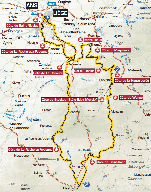
The parcours - click to enlarge
(for a zoombable .pdf, click here)
It's that time of year again. The Flanders Classics, Milan-San Remo and the lunacy that is Paris-Roubaix are all over, as is the first of the Ardennes Classics La Flèche Wallonne; which means it's time for La Doyenne, the oldest of the Monuments, Liège-Bastogne-Liège. First held 120 years ago, La Doyenne was like many races from the latter half of the 19th Century and the first of the 20th originally organised with a view of promoting newspaper sales, in this case L'Expresse - the fact that it was published in French is the reason that the race remained within the French-speaking Walloon region rather than venturing into Flanders, where the cycling-mad natives speak various dialects of Dutch.

Some also call it the toughest Classic, tougher even than Paris-Roubaix. Moreno Argentin, who won four times, said, "Riders who win at Liège are what we call fondisti - men with a superior level of stamina. [The climb of] La Redoute is like the Mur de Huy in that it has to be tackled at pace, from the front of the peloton. The gradient is about 14 or 15 per cent, and it comes after 220 or 230 kilometers, so you don't have to be a genius to work out how tough it is. Liège is a race of trial by elimination, where it's very unlikely that a breakaway can go clear and decide the race before the final 100km. You need to be strong and at the same time clever and calculating - in this sense it's a complete test of a cyclist's ability."

Profile
The Parcours
The race follows its usual format this year with a relatively straight-forward 98km route south to Bastogne that has little in the way of challenging climbs, then a tough 159.5km with ten hard climbs on the way back to Liège. Riders start out from the Place Saint-Lambert in Liège before riding out into the Province of Luxembourg (not to be confused with the Grand Duchy, which it borders), the least-populated part of Belgium; reaching first climb the Côte de La Roche-en-Ardenne after 70km before arriving at the little village Ortho (which has a very interesting medieval church, incidentally). The parcours between La-Roche-en-Ardenne and over the hill to Ortho is around 9km with an average gradient of 5.2% but the steepest part, just before 72km into the race, reaches 17% and it hits 12.5% another half a kilometre up the road.
Climbs with official gradients (gradients in the text refer to absolute maximums, measured on the inside of bends, and are taken from Cycling.be)  

Km 70.0 - Côte de La Roche-en-Ardenne - 2.8 km climb to 6.2 %
Km 116.5 - Côte de Saint-Roch - 1.0 km climb to 11 %
Km 160.0 - Côte de Wanne - 2.7 km climb to 7.3 %
Km 166.5 - Côte de Stockeu (Stèle Eddy Merckx) - 1.0 km climb to 12.2 %
Km 172.0 - Côte de la Haute-Levée - 3.6 km climb to 5.7 %
Km 185.0 - Col du Rosier - 4.4 km climb to 5.9 %
Km 198.0 - Côte du Maquisard - 2.5 km climb to 5 %
Km 208.0 - Mont-Theux - 2.7 km climb to 5.9 %
Km 223.0 - Côte de La Redoute - 2.0 km climb to 8.8 %
Km 238.0 - Côte de La Roche aux Faucons - 1.5 km climb to 9.3 %
Km 252.0 - Côte de Saint-Nicolas - 1.2 km climb to 8.6 %
With the first hill completed, it's only 27km to the turning point at 97km. The feed station is at 98km, then the riders head north on the much hillier return journey. They arrive at the Côte de Saint-Roch after 116.5km, a notoriously harsh climb with an average gradient of 11% and a maximum of 20%, then continue for 43.5km to the Côte de Wanne at 160km, average 7.5% and maximum 13% and into Wanne.

6km after the village is the Côte de Stockeu, sometimes known as the Jewel of Liège-Bastogne-Liège. It's 2.3km in length with an average gradient of 9.9% and a maximum, halfway along, of 21%. Just past the steepest section stands a monument to Eddy Merckx, a likeness of the rider emerging from a rough-hewn lump of granite that also bears a plaque outlining his 525 professional victories - hence the Col's other name, Stèle Eddy Merckx. A cyclist formed from granite no doubt has artistic significance but, as great as he was, even Merckx experienced difficulties on Stockeau; which means there's no shame for those who abandon here.

Côte de la Haute-Levée lies 5.5km ahead, a comparatively easy climb with its average 5.6%; however, the steepest part is still hard-going at 12%. There's a welcome and much flatter 15km section - including the second feed stage at 175km - between it and the Col du Rosier (approached from the south) is by the standards of the Ardennes Classics an easy climb with an average gradient of 3.9% and a maximum 10%. Having passed Spa - hometown of Hercule Poirot and one of Europe's most beautiful cities - the race reaches the Côte du Maquisard at 198km, slightly steeper than the last climb with an average of 5.1% but an equal maximum.

Mont-Theux is 10km further on, average 5.3% and maximum 11%, then at 223km the legendary Côte de La Redoute with its average gradient of 9.7% and maximum 22%. The Côte de La Roche aux Faucons is 15km ahead at 238km - near enough to the finish and steep enough (average 9.9%, maximum 16%) to sometimes prove decisive to the race's outcome - if a strong climber can get a lead here, then keep it over the final climb and through the last 5km, he may take victory. There remain 14km to the Côte de Saint-Nicolas with a steep average of 7.6% and maximum of 13%, followed by the last 5km to Ans - the final 1.5km climbs 79m, which by my reckoning creates an average gradient of 5.5% with the steepest part rising to 13%.

Places of Interest
Montagne de Bueren, Liège
Liège, a city of almost 200,000 inhabitants, once the industrial and now the economic centre of Wallonia, traces its history back to at least 558CE and has much to see, despite having been the destination of 1,500 V1 and V2 missiles after the Allies took the city from Germany at the end of the Second World War (a time during which the people of Liège showed the humanity and bravery, often at great personal risk, by refusing to let the Nazis round up and ship off the city's Jewish population - most of whom would survive the war hidden away in monasteries). The city's most important buildings are St. Paul's Cathedral, dating from the 10th Century but a cathedral only since the early 19th C.; the vast Palace of the Prince Bishops, dating from the 16th C. and the Montagne de Bueren - an outdoor flight of 400 stone steps (maximum gradient 44.2% - who's up for a go at climbing those on their bike, then?). 1.5km away, near Embourg, is a 19th C. fort, one of several surrounding the city, but it's not open to the public and there's little to see.

La Roche-en-Ardenne
Sougné-Remouchamps (called Sougné-Remonchamps on the course guide) at 20km is famous for its caves, which are open to the public who can join tours completed partially by boat along the subterranean River Rubicon. Harzé (27.5km) has a castle which is much younger than it looks, dating from the 16th C but resembling an 11th or 12th C. structure. Manhay (46.5km) has a preserved Panzer tank positioned on a plinth, a memorial to the 1944/5 Battle of the Bulge which saw black American serviceman placed into active combat positions for the first time. La Roche-en-Ardenne (66km) had a 12th C. castle that now lies in ruins, largely as a result of the 19th C. locals who stripped it of masonry to build their homes.

Bastogne (98km), a city of 14,000 people, is also famous for its role in the Battle of the Bulge. It was here that the Nazis, led by crack SS troops, briefly gained the upper hand over the Americans and, for three weeks, surrounded General McAuliffe's troops. The Nazis sent a negotiator to ask him to surrender, but the General replied "Nuts!" and ordered his men to keep fighting. There are several monuments to their eventual victory in the city, including a preserved Sherman tank on a plinth. There's another Panzer tank commemorating the meeting of Generals Patton and Montgomery during the Battle of the Bulge at Houffalize (114.5km), a town considered the centre of Belgian mountain biking - a round of the World Cup was hosted here in 2010.

Tavigny
Tavigny (121km) has a grand chateau with two turrets (your esteemed author, then aged 11, camped in the grounds of the chateau during a family holiday, fell in love with an American woman aged at least 45 and befriended a white goat). Another castle, the Château des Comtes de Salm, once lay a short distance north of Salmchâteau (146.5km) but only the gatehouse and a few ruins exist today - this one too has a goat connection, as legend claims that treasure buried in the grounds is protected by a golden goat. Excavations have indeed turned up numerous gold coins, but it appears the goat prefers to remain a legend. In Stavelot (165.5km) is an unusual Benedictine monastery, founded in 1951, where the monks make a living not by brewing and cheese-making as tends to be the way in Belgium but from the manufacture of latex emulsion paint. The area, including Francorchamps (175.5km), is world famous for the Spa-Francorchamps motor racing circuit which has been in use since 1921 - incredibly fast and, before changes were made, notoriously dangerous, many drivers called it the most beautiful track in the world.

Spa (192km), also known as the Water City, is the place that gave its name to all other places in the world that have water with supposedly health-promoting effects. The water here has been famous since Roman times and wealthy people from across Europe would come here to bathe in it, claiming various medicinal benefits. In the 18th C. the first casino opened up to give them something to do at night as well (aristocrats get up to all sorts of no good if you don't keep them amused, after all) and the rich began building chateaux, rapidly making the city very prosperous indeed. I have swum in the waters at Spa, which a guide said would relieve and possibly even cure my arthritis. It did not.

Franchimont Castle
11.5km from Spa lies Theux, site of Franchimont Castle. Of great military importance since the 11th C., the castle lost strategic value in the 17th C. when improvements in artillery brought it within range of guns on the other hills nearby and it was put into use as a prison until the Napoleonic era when it was sold to a wealthy business man who used it as a quarry, turning it quickly into a ruin. Though unfortunate, this destruction may well have been of aesthetic benefit; and it's a beautiful sight today. Boncelles (241.5km) has another of those 19th C. forts protecting Liège, part of the same network as the one at Embourg. Mostly subterranean, its grey aeration tower gives away its presence and acts as a landmark. Seraing (242km) became a manufacturing centre during the Industrial Revolution, home to factories and mills established by Lancashire-born John Cockerill - the same man who produced the cast iron (not bronze from captured French cannon, as locals will try to tell you) lion atop the Butte du Lion as seen in the Brabantse Pijl two weeks ago. Though not so well-known in Britain, Cockerill is famous throughout Wallonia as the Father of Belgian Industry (and unlike most entrepreneurs of his day, he wasn't a greedy, exploitative fatcat either - by all accounts, he took an active interest in the well-being of those who worked in his factories and by the standards of the times treated them very well). Finally, having passed through the centre of Liège, the riders arrive at the finish line at Ans (257.5km), a contiguous suburb of the city and home to the medieval Château de Waroux which was at the centre of the Guerre des Awans et des Waroux in the 13th C., a private feudal war between enemy noble families that left 30,000 people dead (hence the point above about keeping the aristocracy amused).

Weather
La Doyenne has seen some atrocious weather during its long history, most notably in 1980 when heavy snow fell along the entire parcours and commentators renamed it neige-Bastogne-neige ("snow-Bastogne-snow", which they probably thought extremely witty). It won't snow this year (probably; you never can tell in the Ardennes) but it's not going to be what anyone would call a nice day either. Temperatures at Liège as the riders set out won't be much above 6 or 7C and a 19kph south-westerly will take the edge off that, making it feel more like 1 or 2. There's a very high chance it'll be raining, too. It should be warmer when they get back, around 11C, but it'll still be raining. Bastogne is set to be at least a degree or two colder and rain look equally probable here.

Favourites
Samuel Sanchez
The Brothers Schleck (RadioShack-Nissan) said on Friday that they intended to win, but their form thus far this season suggests they're going to have a hard job making it happen - however, let's not forget that both of them can climb like angels and if they do suddenly start performing well they could both do well. Frank in the top ten? Perhaps. Joaquin Rodriguez (Katusha) also climbs like an angel and he can ride like a demon on the flat sections too - he won't like the weather, being from warmer climes, but rivals will have to work hard to keep him at bay. Unless the unforeseen happens, his team mate Oscar Freire will as always be lurking around at the front of the pack when the finish line draws within site and he's shown time and time again that if an opportunity arises, he'll grab it. Philippe Gilbert (BMC), last year's winner, enters the race as many people's favourite and he's started showing a return to form recently after a slightly lacklustre start to the season, so this may prove to be his day. Finally, my choice: Samuel Sanchez (Euskaltel-Euskadi) - the Tour of the Basque Country is, oddly, not as far removed from this race in terms of similarity as it is geographically: the hills are bigger, but along the way there are a lot of tough little ramps. This was especially the case on the final stage which on paper looked flat, but in reality turned out to be a series of nasty surfaces and cruel little climbs. Upon it, Sammy was in his element and performed far beyond expectations, slaughtering the opposition and gaining a decisive victory. He's also one of the very few climbers able to descend every bit as quickly, which while this is a race that does not tend to give rise to successful breakaways might still give him the advantage he needs to at least remain well-placed for the final uphill sprint. (Start list here)

Coverage
British Eurosport are covering the race live between 14:00 and 16:00BST. Online feeds of varying legality will be up from around 13:00BST (14:00 local time/CEST) and as ever, Sports-Livez is a good place to look for them. The official race ticker will be available at the official race website; Eurosport, Sporza and Cycling News all have their own in English. Twitterers seem to have decided on #LBL as the hashtag of choice.


Wednesday, 14 March 2012

Milan-San Remo 2012

Milan-San Remo 2012 (click to enlarge)
Definitive start list
Route details

All the Classics have history, but Milan-San Remo has more history than most. For many fans, it is the most important of the five Monuments, the venerated races that are the most prestigious of the Classics and widely considered secondary only to the Grand Tours. A list of winners is a list of the fastest riders from the last 105 years: Petit-Breton, Christophe, Garrigou, Pélissier, Defraye, Girardengo, Binda, Bartali, Coppi, Bobet, Van Steenbergen, Van Looy, Poblet, Poulidor, Simpson, Merckx, De Vlaeminck, Moser, Kuiper, Kelly, Fignon, Chiappucci, Zabel, Cancellara, Cavendish.

The final climb, Poggio de Sanremo, was introduced into the race in 1960 in an attempt to prevent it from ending in a bunch sprint every year and despite being known as the Sprinters' Classic, there are hills: the Passo del Turchino is a long grind up to 532m, not steep but for the final part, Le Manie tops out at 318m but is much steeper, Cipressa only hits 239m but is also steep - it's the reason many people though Cav couldn't win this one. He took them all by surprise in 2009 when he climbed them with relative ease, then beat Heinrich Haussler across the line to become the first British rider to win this race since Tom Simpson in 1964. Now he says that a second victory is one of his main targets for 2012, and when Cav locks onto a target he's as good as unbeatable.


The race begins at the Piazza Legga Lombarda in Milan (45°28'39.56"N 9°10'51.64"E); an attractive city street with flat cobbles and tramlines by the neoclassical Arena Gianni Brera, previously known as the Arena Civica, which in the 19th Century hosted Bill Cody's famous Wild West Show - as did the Buffalo Velodrome in Paris, once run by Henri Desgrange. It then runs south along the Via Legnano to begin a neutral zone of approximately 7.21km, following the streets through to the famous Castello Sforzesco. This vast citadel, one of the largest in Europe, was once the seat of the powerful Duchy of Milan - itself dating back to pre-Roman times - and now houses several important museums and art collections in addition to the Salla delle Asse, a room with a ceiling decorated by Leonardo da Vinci. Having played an instrumental role in the early days of the Christian faith in Europe, the area surrounding the castle is sometimes known as the Centre of Christianity. After following the road around the castle, the riders turn left into the Via Marco Minghetti and come out at the Piazza Cadorna with its fountains and colourful modern sculptures, then pass into the Via Giosue Carducci. Just visible at a few points are Basilia of Sant'Ambrogio, dating from the 4th Century AD and one of the oldest churches in the city. It is the burial place of several martyrs, killed as a result of Roman persecution of Christians, and of Emperor Louis II. The basilica was much damaged by Allied bombing in 1943, as can still be seen in some parts, though arguably more damage has been done to the complex by the inclusion of the modern and spectacularly ugly museum and office building. That's just the first few kilometres.

Certosa di Pavia
(image credit: Tango7174 CC BY-SA 3.0)
The route takes the  the Largo Paolo d'Ancona, and eventually winds its way to the edge of the city and takes the Via della Chiesa Rossa leading away from the ancient city, then onward past Rozzano (45°23'14.86"N 9° 9'5.04"E) - a small town that has officially been a city since 2003 and which boasts an attractive, apparently semi-derelict fortified manor house. The road becomes known as the SS35 and passes Binasco and Casarile, then bisects Certosa di Pavia with its enormous and world famous monastery complex built in the 14th and 15th Centuries by the Carthusian Order. It has changed hands several times since but is now owned by the State, though a small community of Cistercian monks have lived there since the 1960s. We reach Pavia a short while later, its spires and towers visible from far away across the flat fields (45°11'9.93"N 9° 9'23.61"E).

Once the capital of Lombardy, Pavia is home to a university founded in 1361 and has many important buildings, the most famous of which is the Cathedral - begun in the 15th Century, it's still not finished. For a short time, the city was also home to Albert Einstein. A short while after passing Cava Manara, the riders arrive at a bridge crossing the Po at 38.7km from the start of the race. Gradually, after Bressana  Bottarone, the road begins to climb; almost imperceptibly at first and then more rapidly at Voghera after 59.8km where there is a museum that exhibits the gun that was used to execute Mussolini. Here, the parcours takes the SP93 and continues south-west to Tortona, the largest conurbation the race has seen since Milan and the chosen home of Fausto Coppi who died here in 1960 - the city's stadium is, unsurprisingly, named after the man who for many is Italy's greatest sporting hero but it seems a pity that the race does not pass through Castellania 12km to the south-east, his birthplace. From this point, the altitude rises far more steeply and for the first time becomes a problem for the sprinters, once of whom will most likely win the race - look to see who shows signs of suffering and then keep an eye on them in the steeper climbs to come, as this may be indication that they won't have the strength to compete in the final sprint to the finish line.
Altimetry (click to enlarge)
After 91km, the riders reach Pozzolo Formigaro and then a few kilometres later Novi Ligure (44°45'42.47"N  8°47'9.96"E), birthplace of the legendary Costante Girardengo who was Il Campionissimo long before Coppi was and held the record number of wins in this race (6) for almost five decades until Eddy Merckx won a seventh in 1976. When they reach Bassaluzzo a few kilometres later, the riders have complete the first 100km - and have a little under 200 still to go.

Rossiglione
(image credit: Davide Papalini CC BY-SA 3.0)
The road turns south and becomes the SP155, passing by Capriata d'Orba and Silvano D'Orba. Silvano has a castle that looks the ideal home for a vampire, set on the edge of the forested hills east of the town. 6km away is Ovada, built in between two rivers and jut small enough to feel like an island, after which the race turns into the forested hills and what is perhaps the most beautiful section following the course of the Stura river through Gnocchetto and over a level crossing, then onward through Rossiglione to Campo Ligure. Here, the riders arrive at the first of the two feeding stations and the beginning of the first proper climb, topping out at the Passo del Turchino 532m above sea level (44°29'13.52"N 8°44'6.78"E). In years gone by, this pass frequently decided the winner of Milan-San Remo - in 14 of the first 39 editions, the first man to the top went on to win; but the route has been much-altered over the years and today, only 134km into the race, it's too far from the finish to make much difference and as roads and levels of athleticism have improved it no longer fractures the peloton. The gradient is very low, topping 4% only during the last few metres before the highest point, which is located within the 180m long Passo del Turchino Galleria tunnel (44°29'12.38"N 8°44'6.36"E). The descent, meanwhile, is steep in parts - it drop more than 400m in the next 8km with some sections of 10% encouraging high speed around the hairpins and through the next tunnel (120m) on the way to Mele. (Random fact - in 1910, there was so much snow on the pass that only 4 out of 63 riders made it across.)

Once the Turchino has been passed, the race becomes a very long, very fast sprint for much of the remaining 155.7km with only a few smaller climbs - Le Manie, the three Capi, Cipressa and the Poggio del San Remo to break things up. Expect a large breakaway, and probably several smaller ones too, to try to gain an advantage here and also keep your eyes on the sprinters as their teams nurse them through the kilometres in an attempt to conserve their energy for the last section.

Arenzano
(image credit: Nijnemans CC BY-SA 3.0)
Mele is perhaps not the most attractive town in this part of the world, its best features being the bridge that carries the autostrada high overhead and the views down the green valleys to the Meditarranean which lies only 2km away to the south at Genova Voltri (44°25'50.11"N  8°44'51.85"E), the next town, where the riders will have completed the first half of the race. From here, the parcours runs along the rugged and very beautiful coast of the Italian Riviera. A short way beyond Voltri, it passes through a series of tunnels and then arrives at Arenzano. A short climb takes the race through La Colletta and then to Cogoleto, birthplace of Christopher Columbus and once the site of a Roman bridge - until Allied bombs did to it what the centuries had not.

Fortezza del Priamar
(image credit: Basilico CC BY-SA 3.0)
After another short climb, we reach Castello d'Invrea where the fabulously wealthy come to buy holiday mansions for fabulous sums and the locals leave to find homes they can afford. Next is the  descent into Varazze (44°21'38.00"N 8°34'33.75"E) which was once the home of notable anti-Fascist Lelio Basso, a lawyer who sat on the Russell Tribunal alongside the great Welsh philosopher Betrand Russell himself and Jean-Paul Sartre, investigating allegations the USA had committed war crimes in Vietnam - and found the nation guilty of genocide. Celle Ligure and Albissola Marina come and go as the peloton passes through the 300m Capo Torre tunnel before arriving at Savona, birthplace of two popes,a president, a prime minister and numerous footballers. Standing high on a hill above the town is the Fortezza del Priamar, a vast castle that served as Italy's main military prison until 1903. Vado Ligure (44°16'9.82"N 8°26'9.06"E) is the next recognisable town, Zinola being squeezed in between it and Savona so that it seems nothing but the two linked together. Vado Ligure is an industrial city with a commercial port and a locomotive manufactury, making it in many ways a more interesting place than the pretty tourist traps we've passed so far along the coast.

7km later, the race reaches Spotorno and passes through a 220m tunnel. 3.5km further on is Noli (44°12'20.96"N 8°24'59.01"E) - a tiny town nestling in a wooded valley, but one with an impressive past: between 1193 and 1797, Noli was a self-governing independent nation, the smallest of the Maritime Republics that included Venice and Pisa. The church, San Paragorio, was the cathedral until independence ended with the Napoleonic invasion of 1797. Just outside Noli the race reaches the 200km point, roughly two thirds of the way to the finish, then the  following 4.7km become harder on the sprinters as the parcours briefly leaves the coast and they climb Le Manie. Once again the hill is not high nor steep enough at 318m to decide the race nor prove too much of an obstacle, but coming after so many kilometres it's far from easy.

Porta di Finalborgo frescoed gatehouse,
Finale Ligura
(image credit: Mau CC BY-SA 3.0)
A fast descent leads into Finale Ligure (44°10'14.63"N 8°20'47.94"E), considered by some to be one of Italy's most beautiful towns due to its wooded hillsides, frescoed medieval gatehouses and ancient churches, then the race continues through Borgio Verezzi and Pietra Ligure. Nearby are the Grotte di Borgio Verezzi, caves created when water dissolved soluble bedrock to leave hollows between other rocks. Remains found in the caves show that the region has been inhabited by humans and human ancestors for as long as three quarters of a million years. Loano and Borghetto Santo Spirito are next. The latter does not benefit from unattractive high-rise buildings that sprang up in the 1960s and 70s, but the Castello Borelli which perches on a rocky plinth as though it grew from it is very impressive. Ceriale, 2km away, hosts the second of the two feeding stations - the town's population increased sharply in the Middle Ages due to an influx of people fleeing nearby Capriolo when it was overrun by an invasion of biting ants. In the 16th Century, Ceriale was attacked several times by Arabic pirates which led to the construction of a circular fortification on the beach - it proved to be of little use when Barbary pirates from North Africa attacked in 1637 and looted the town.

Having negotiated streets of varying prettiness and width through Albenga, site of an 11th Century cathedral, the riders cross a bridge and take the SP1 leading to Alassio (44° 0'14.07"N 8°10'5.72"E), which inspired Edward Elgar to write an overture (the town repaid the honour by naming a street after him) and which is usually included on lists of the most beautiful locations in Italy. Laigueglia is next, then it's on to the first of the three Capi, hills low enough to have little if any effect on the outcome of the race. This one is the 67m Capo Mele where there is a lighthouse bulit originally in 1856, then extensively rebuilt in 1947-8 after it was badly damaged by Allied shelling in the Second World War. At the bottom of the descent the riders arrive at Andora and have 50km left to the end of the race. There is a velodrome in the town and the environs are popular among mountain bikers. The 61m summit of Capo Cervo is reached 3km after the town, then we drop into Cervo which marks the beginning of the Cervo/San Bartolomeo al Mare/Diano Marina conurbation where the three towns have grown to become contiguous. Diano San Pietro, up in the hills, will soon join them.

Porto Maurizio, seen from the west
(copyright-free image)
Capo Berta - by far the highest of the Capi at 130m - lies 2.5km on from Diano Marina. Once they're over, we may begin to see the peloton become a little more animated as teams alter their tactics to protect the printers over the last two climbs, also stepping up the pace in an effort to reel back any breaks that are still off the front. Imperia (43°53'18.38"N 8° 2'7.11"E) is reached after the descent and a short climb of 30m; its rather grand and militaristic name is something of a misnomer as the locals chiefly concern themselves with the cultivation of flowers and olives. It is in fact two towns - Oneglia, sited on a low plain, is the more modern half and has a commercial port; while Porto Maurizio stands on the hillside on the western side of the river, where the wealthy have expensive homes along its picturesque winding streets. Once, they were separate entities, then Mussolini decided to join them together and give them that high-falutin' name in 1923. San Lorenzo al Mare is 6.1km away and upon reaching it the riders will be as pleased to know that they have less than 30km to go as they will be unhappy that the town marks the beginning of Cipressa (43°51'4.65"N 7°56'22.10"E), the penultimate climb of the race: it's only 239m high and rises to that altitude in around 11.5km so it's not steep, but coming after 276km it can still make their knees hurt. Sprinters who are obviously suffering here can be ruled off lists of potential winners with some degree of certainty, though it should be remembered that some - most notably Team Sky's Mark Cavendish - have phenomenal recovery times.

Current World Champion Mark
Cavendish, known and respected as
one of the fastest sprinters in the
history of cycling, is widely regarded
as standing a good chance of
repeating the success he had in this
race in 2009 - the year he became the 
first British winner since Tom Simpson
in 1964.
(image credit: Mogens Engelund CC BY-SA 3.0)
With the fast Cipressa descent out of the way the peloton arrives at Santo Stefano al Mar, then Riva Ligure and Prai before crossing a bridge into Arma di Taggia (43°50'17.26"N 7°51'22.22"E) - where they have a little under 15km left to ride. Taggia as a whole is the largest town we've seen for some time with 13,000 inhabitants. The race remains near the coast on the SP1 but the town can be seen stretching north into the hills before the riders tackle the last tunnel (142m) and move on to Bussana, round Capo Verde and begin to climb 160m Poggio di San Remo - the last climb of the race and the place where the teams arrange themselves into formations designed to be able to lead their best hopes over the mountain and into the last section where they can blast off toward the finish. According to the Inner Ring, parts of the road have been resurfaced and are faster than ever. It's possible for a solo attack to result in a win here, as Paolo Bettini proved back in 2003 (nobody else has managed it since, though many have tried), but the race almost invariably ends with a bunch sprint.

The peloton enters San-Remo along the Via Aurelia, continuing when it becomes the Via Guiseppe Mazzini and then the Corso Felice Cavallotti. This leads them to the Rondo Garibaldi where they will turn left onto Via Flume, then right onto the Corso Orazio Raimundo and left 300m later for the Via Nino Bixio. From here, it's all about high speed as the teams lead the sprinters left at the Giardini Vittorio Veneto ready for them to switch on the afterburners and launch themselves at the finish line by the seafront on the Lungomare Italo Calvin (43°48'49.96"N 7°46'28.97"E).

Thor Hushovd - Cav's biggest rival
(image credit: PB85 CC BY-SA 3.0)
Cyclopunk's Top Tip: Cav. Those hills are well within his definition of doable, and once he lights the blue touch paper in a sprint he's as good as unbeatable. He has a rock-hard team to help him including the tried, tested and trusted tough guys Edvald Boasson Hagen, Mathew Hayman, Jeremy Hunt, Christian Knees, Thomas Lofkvist and Ian Stannard; each of whom has seen combat and achieved impressive results in either this race, the other Classics or both. Cav's also got Bernhard Eisel, his lieutenant and lead-out man and with whom he forms 50% of what may be the best-rehearsed double-act in the history of cycling.

It's hard to see any other team working so well together as Sky who, as became apparent at Paris-Nice, have spent all winter honing their technique. BMC are likely to be the biggest threat - the team as a whole may not work so well but Thor Hushovd, Alessandro Ballan and Philippe Gilbert (assuming he's improved his form since the Tirreno-Adriatico) are each capable of winning this race. If they can operate as a unit, Sky will need to work extra hard. GreenEDGE will certainly be wanting to win, not least of all because a Monument in their first season - after a start which some have called "lacklustre" - would silence the critics. Then there's RadioShack-NissanTrek - their team seems less likely to operate as one somehow, but with Cancellara aboard it might not matter: on a good day, Cancellara could win this race solo.

TV: In Britain, the race will be televised live on Eurosport from 13:15. It will also be showing on Eurosport in most other European nations and live streams will be available from all the usual sources.

Friday, 9 September 2011

Vuelta a España - Stage 20 Preview

Stage Map: click here
Stage Profile: click here
More Previews: click here

Well, this is it folks. We've been to Cordoba, Burgos and Aviles. We've seen the arid semi-desert in the south and centre of the country and we've seen the lush, green fields of the north-west. We've even been up Alto de l'Angliru, perhaps the most challenging feature of any Grand Tour. Now we're on Stage 20, the last of the "proper" stages before the more-or-less ceremonial short trip into Madrid and the winners' podium.

But this is the Vuelta, and while we've seen all the challenges listed above and many, many more, there was no way Stage 20 was going to be easy. It's 185km long - far from the longest, but a serious test after nearly three weeks' of racing and 3050km, but the organisers have decided that's not enough of an ordeal so they've included some fair old mountains along the way too. The first, a Cat 2, is no Galibier but will certainly leave the riders on no doubt that their suffering is not yet over; the second is a Cat 1 with 555m of climbing in 7km; the third's a Cat 3 positioned perfectly to sap all but the very last grams of strength before the final Cat 1, a 505m wall. Lovely!

Bilbao is stunning by night (and thus presumably not at
all popular with nearby astronomers). There's much more
information on the city in the Stage 19 Preview.
The stage begins where Stage 18 left off, in the fine Basque city of Bilbao. Setting out from Botikazar Erribera (or Botica Vieja, as the Spanish language road book prefers it) no the northern bank of the river, the riders travel east for 0.22km before turning right at the roundabout and along the Puente Euskalduna, the bridge they crossed twice in the opposite direction yesterday. They then arrive at the Sagrado Corazón, taking the opposite exit onto the On Diego Lopez Haroko Kale Nagusia (Gran Vía Don Diego López) before a left turn at the Plaza Don Federico Moyua to enter the Alameda Recalde. Having crossed the Puente de Salve, the race follows the first slip road on the right down onto the Maurice Ravel Etorbidea and progresses eastwards towards the tunnel separating it from the Zumalakarregi Etorbidea, following the route round a wide left-hand bend and onto the N-634. The neutral zone comes to an end 9km from Botikazar Erribea, roughly halfway between Kukullaga and Agirre-Aperribai.

The peloton continue through Galdakao, the wide and smooth road offering up no hazards en route. The town - home to almost 30,000 people and the birthplace of cyclists Ramon Gonzalez Arrieta, winner of the 1995 Classique de Alpes (which ran for fourteen years until 2004, living on since 2007 as a juniors' competition), and Igor Antón,  who is racing today with local team Euskaltel-Euskadi - is unsurprisingly rather overlooked due to its more famous neighbour. However, it predates Bilbao; having been first mentioned as a town in a document connected to its official application to become part of the city during the 14th Century. The application was successful, permitting it to enjoy the same privileges and thus grow rapidly up until 1630 when it once again became a separate community. The Industrial Revolution, for all the pollution and suffering it cause, was good to Galdakao - quarries, mines, forges, a dynamite factory and, in 1882, the railway saw the city grow rich.

Idolo de Mikeldi and Cruz de Kurutziaga, Durango
Having passed underneath the A-8 motorway, the race travels by various communities including Elexalde and Gumuzio before reaching countryside followed all too rapidly by industrualised areas. The road swings back and forth across the motorway before a slip road leaves on the left, curving around to the right and swooping under both the N-634 and A-8 into Amorebieta-Etxano. Turning left at the upcoming junction carries the peloton along the San Miguel Kalea or BI-3334. Straight ahead at the roundabout on the edge of the town leads towards a large B-shaped intersection, with the BI-3334 merging back into the N-634 before it travels east past more industry and comes to Arriandi - a town given over almost entirely to industry - with 21.4km ridden from the start of the race. Durango comes next; the town made famous by the discovery of the prehistoric Ídolo de Mikeldi, a four-legged animal roughly the size and shape of a boar. Its purpose remains a mystery, but the most likely explanation would be an object of worship among the ancient pre-Roman tribes who lived here thousands of years ago (it can be seen in the Museum of Archaeology, Ethnography and History in Bilbau). The Cruz de Kurutziaga, a heavily-carved Gothic cross and the only one of its kind on Europe, attracts more visitors to the town that any other feature - the one outdoors is in fact a replica (an identical replica stands in the same museum as the Ídolo de Mikeldi), the original having been moved inside the Ermita Cercana de la Veracruz nearby following a vandal attack in 1981. Though the majority of the figures represented upon it are recognisably characters from the Bible, the presence of various suspiciously pagan-looking symbols has led to much speculation as to who carved it and why.

Palacio de Berriz
The first climb - uncategorised, hence no points - begins just outside Durango before the race continues along the N-634 past Trana-Matiena and on to Berriz, 30.2km from the start. Zaldibar lies 2km ahead. The peloton turn left, passing under the A-8 once more and entering the small community on the Bilbao Etorbidea. Just a few kilometres away to the north-east is Mallabia, the home of the Orbea bicycle firm - producers of some of the most desirable bikes in the world, including those ridden by the Euskaltel-Euskadi team. The route joins the San Andres Etorbidea in the middle of the town, leading out to a wide 90 degree right shirtly before a wide, unchallenging hairpin located 1.55km after the motorway underpass. The summit, at 310m, comes at the second of the two sweeping left-handers soon after the hairpin; then the race reaches an industrial unit with a truck depot making it a potential spot for hazardous diesel spills on the road. 310m is reached several more times before the easy descent into Ermua. Ermua, though inhabited since at least the bronze age, grew up as it became a dormitory town for the local industry, with many of the inhabitants employed in the metal working factories. However, unlike many towns of its type, which apparently exist solely as a place in which to store a workforce overnight, it's a place with a unique character of its own and several fine buildings. Among them are the 16th Century Palacio Lobiano, considered one of the best examples of Renaissance architecture in the region, and the 18th Century Baroque Palacio de Valdespina. The town has also produced two professional cyclists - Pedro Horrillo, wingman to Oscar Freire until a horrific accident in Stage 8 of the 2009 in which he plunged over a 60m cliff and was left with multiple fractures and a punctured lung, ending his career; and Igor Astarloa, who paid tribute to the town when announcing his decision to retire after doping allegations in 2010.

Continuing along the N-634, the route reaches Gipuzkoa and then Eibar. According to the Vuelta itinerary, the race progresses along the Calle Iruri and Calle Juan Guisasola - however, there is no road called Iruri in the town - we think they mean the Calle de Isasi (or Isasi Kalea as we prefer to call it, since we favour the Basque names). Secondly, the Calle Juan Guisasola comes after, not before, the right-hand turn and is also known as the GI-2639 - they are not separate roads as the race details suggest. This leads to some confusion as to the precise location of the stage's first intermediate sprint - it's either on the N-634/Isasi Kalea before the turn, or on the GI-2639 afterwards. The first climb, Cat 2 Alto de Karabieta with 425m of climbing in 6.8km, begins immediately after the sprint.

"Torre" de Urrapain
Having passed to the left of Eibar's bullring and football stadium (football being another sport beloved by the Basques, bullfighting being an atrocity sadly endemic throughout Spain), the route crosses the A-8 on a fly-over. There are a few bends on the way up - though no hairpins - but due to the lower speeds during climbs they shouldn't cause problems. The summit, 560m above sea level, comes shortly after the peloton emerge from forest by some buildings. The descent is similarly easy, though a long, thin traffic island just as the race enters Elgeta could prove hazardous to the unwary. Elgeta has an immediately noticeable different character to the towns north of the climb the race has just completed, being predominantly rural in nature - the name is derived from the Basque term elke, meaning "cultivated field." The town looks modern, partially as a result of heavy bombing right up until 1937 during the Civil War. It retains a handful of older structures, however, including the Iglesia Sra. de la Asunción, dating from the 14th Century but much re-modelled in the 16th; the Torre de Urrupain, not actually a torre at all and more fittingly also known as the Casa Abidrío, with an impressive Baroque facade; and the ruined 13th Century Ermita de Uriarte.

Ubera. The year? 1970. (From kzgunea)
The road book itinerary takes a little departure from reality again in Elgeta, instructing us to turn left onto the GI-2631 - unfortunately, the GI-2631 is quite a long way away to the east and doesn't go to the next village Ubera. The GI-2632, meanwhile, not only goes there, it also runs through Elgeta; making it seem by far the more likely to be correct. After turning a tight - and potentially slippery - left onto this road, the peloton encounter right-hander, wide but steep hairpin 0.73km later. The final descent into Ubera is fast but not technical with the exception of a final right-hand hairpin on the entry into Ubera. Preceded by a sweeping 90 degree left, it will be approached at high speed and riders who haven't studied the route could very easily find themselves taking the section too fast and crashing into the trees on the left side of the road. Add to this the rural nature of the surroundings and there's an added hazard posed by the possibility of mud on the the road.

If you blink, you'll miss Ubera - it's a tiny village with few buildings, plus the race passes straight through. Following a few unchallenging bends right after the village, the road becomes straight for a 1.1km descending section likely to encourage high speed, followed by a tricky medium right/tight 90 degree left/medium 90 degree right combination before passing under the AP-1 and GI-627 into Bergara where the peloton turn right at the first roundabout onto the Calle de Amillaga. There are a number of speed humps from this point until we leave the village behind. At the end of the road they turn a tight left onto another section of the Calle de Amillaga, passing right across a roundabout and ahead onto the Calle de Leiziriako San Lorentzo. This becomes the Calle Mugerza and, after a short narrow section where the road is constricted by a building on the right, onto the Calle Zubieta which follows the banks of the river for a short distance before disappearing behind houses and becoming the Calle Mahasterreka. The Cat 1 ascent of Alto de Elosua with 555m of climbing in 7.3km begins with 57km ridden since the start of the race.

Torre Moyua, Bergara
Though Bergara - called Vergara in Spanish - has a fine selection of interesting features (especially the megalithic monuments including dolmens and long barrows in the surrounding hill) it experiences very little tourism, both as a result of and resulting in the town's reliance of heavy industry and metal working. It's very much a town where people live and work rather than holiday, but a tourist in the area could spend a day or two without getting bored. Highlights include the Casa Arrese, dating from the 16th Century and a superb example of a Renaissance urban palace; the Torre Gabiria, constructed during the 15th Century with various features added during the 16th, prior to to a fire in 1719 and subsequent rebuilding; the Torre Moyua, more palace than defensive tower, though it incorporates various decorative elements based on defensive architecture; and the Hórreo de Agarre, a large granary held together entirely by dove-tailing with no nails used in its construction.

A footbridge crosses the road on the eastern perimeter of the town, then two sweeping left-hand bends lead into a right-handed, tight and steep hairpin before the road leads right and right again into trees and a short descent. An easy 90 degree left leads past houses, followed by an untechnical section up to the second hairpin - a left, not too tight and less steep than the previous; then a similar one turning right 0.56km ahead. A long straight section leads up to the fourth, left, wide and not steep; the the road passes among trees and emerges near the fifth, right, wide and medium steepness, bringing the road up to 600m. The final section takes place along the following straight section, the summit reached at a crossroads on the edge of forest. There's a wide 90 degree left bend just as the road leaves the trees behind.

Elosua (CC3.0)
The initial part of the descent to Elosua shouldn't be particularly demanding unless the weather's wet, though there are some potential trouble spots further down. The most evident are the series  very sharp bends starting 0.33km after the junction with the GI-3742 as the road follows the contours of the mountain; a section which, with fast entry speeds, descending altitude and trees, have all the ingredients necessary for a few crashes. Having left the forest and entered open countryside, the route negotiates a medium 90 degree left leading past a building, then enters a very tight 90 degree right. Two smoother rights lead into a straighter section, followed by a sweeping left-hand bend and another very tight 90 degree right back among trees. Once exited, a final straight leads to a junction with the GI-631 where the race turns right. Though this road features many bends, it's slightly uphill and will thus reduce speeds becoming less dangerous as a result. It's crossed several times by footbridges, each of which are likely to be packed with spectators - none of them stupid enough to try dropping anything onto the riders as they pass below, we hope. Police may prevent them from tying banners, flags and suchlike to the bridge to prevent this risk. Presently, the peloton come to a tiny village strung out along the road in a narrow, forested valley - Aizpurutxo, 79.3km from the start of the race. It's a poor, ramshackle, rather dirty and utterly charming little place.

The road away from Aizpurutxo has many bends, but each is wide and as the road climbs slightly speeds will remain low enough to avoid crashes. However, one potentially dangerous point comes after 3.1km, in a place where the mountainside right of the road has been stripped bear of trees, allowing the topsoil to wash away. This has left bare rock, leading to a very high likelihood of gravel on the road which can easily cause loss of traction - and unpleasant crashes as a result, since crashes on gravel often result in gravel having to be picked out of the skin. Just after this section is a series of tight bends: 90 degree left/90 degree right/90 degree very tight right/90 degree left/90 degree left/very tight 130 degree right. Houses and other buildings begin to appear along the roadsides and then - having added another 7.4km to the total ridden - the race arrives at Zumarraga and a series of tunnels. All are illuminated, the first being 0.13km, the second 0.1km and the third 0.17km, resurfacing just south of a roundabout and almost immediately merging into the GI-632.

Zumarraga
Until the late 15th Century, Zumarraga was a scattered collection of tiny hamlets and isolated farmsteads, a place apparently hardly even noticed with the first documentary evidence of its existence as a community only a hundred years previously. Gradually, an urban centre began to form and in the 16th Century the parish authorities applied for the right to relocate the parish church from its original site in the mountains to this new town. From this point, it developed rapidly; growing much larger during the 19th Century and becoming the fine and pleasant town that it is today during the early part of the 20th Century. By 1977, the population was almost 13,000; though this has fallen to around 10,000 today.

The peloton leave the southbound GI-632, curving back up to the roundabout they passed beneath and turning left for the westbound section, a road that will take the race all the way back to Bergara. An uncategorised mountain - hence no points, even for a rider who climbs it like a squirrel on EPO climbs a tree - begins as soon as the race leaves the town, the summit coming after 4.9km among farm buildings just after a series of wide, sweeping bends. A very tight pair of right/left hairpins form a S-shaped section 0.55km after the bus stops near the summit: they're steep, tight, surrounded by trees and lead straight into a tight left and medium right. Add all this together and mix in the high entry speed after half a kilometre of descent and we have the perfect recipe for some hairy near-misses if not a few actual crashes.

Another tight, steep right-hand hairpin follows after 0.34km with a medium left-hand bend in another 0.44km and a very tight right-hander - almost a hairpin - 0.2km after that before the road straightens out for the final stretch before Antzuola, with a slightly tricky section involving a central reservation and a strange roundabout. The descending road immediately after the village may also be hazardous, especially after rain when leaves from the thick forest either side of the road could lead to very slippery conditions. The same applies to two corners at the end of the section, one wide left and the next a tighter right. Having emerged from the forest, the road splits into two with the race taking the left path to travel through the 0.34km illuminated Zubiaurre  tunnel passing underneath an entire suburb on the south side of Bergara. The feeding station is nearby.

Postcard dated 1923 from Bizkaia
Once out of the tunnel, the peloton arrive after 1.55km at a pair of roundabouts. Turning right at the first and left at the seconds takes them onto the GI-637 heading south and, a short way along the road, passing underneath the AP-1 motorway and crossing the river twice in within a kilometre. The route follows the road out of the next roundabout and heads to the left. At the large and complicated interchange just beyond the upcoming bends, the race turns right to travel along the GI-632. Category 3 Alto de Kanpazar with 273m of climbing in 5.4km begins at the 106.6km point.

Having climbed to 385m, the route passes by a house and enters a medium right-hand bend as the road becomes the BI-632. The 460m summit comes 1.1km after the bend by a recreation ground just over the border in Bizkaia Province. There a number of technical sections on the descent: the first is a tricky medium left situated 0.58km after the building at the recreation ground, a bend that wouldn't be at all difficult were it not for the preceding descent and surrounding trees; a tight right 0.85km later; a very tight (90 degrees +) 0.33km after that; a sweeping right 0.91km further on and a medium hairpin 0.32 after that to finish - it's an unusual one in that the entry and exit are roughly level, but the apex of the bend dips several metres lower.

Arriving at a junction shortly before Elorrio, the route turns right onto the Av. del Arrasate which becomes the Elizaburu Kalea following the junction with the BI-2632. At the end of the road, the road book itinerary instructs us to turn left onto the Calle San Pio, by which we think they probably mean the Calle de San Pio X or San Pio X Kalea. This leads onto what the Vuelta calls the Calle San Justo, in this case apparently meaning the Calle de San Fausto or San Fausto Kalea, location of the stage's second intermediate sprint. This route leads, as the road book says it should, to the BI-636 heading into Atxondo.

Portal de Don Tello
Despite Elorrio's reliance on heavy industry and the large number of industrial plants in the vicinity, the town is famous for its splendid architectural heritage and has a range of grand palaces and religious buildings. Among them are the Palacio de Estéibar-Arauna, the Palacio de Arabio and the Portal de Don Tello. The latter - the last remnant of the town's medieval wall - is still equipped with a cannon. Also not to be missed are the Iglesia de la Purísima Concepción, considered one of the finest Renaissance churches in the Basque Country but in fact of 15th Century Gothic origin, and the  Necrópolis de Argiñeta - one of the oldest Christian burial sites in the region. It's also the birthplace of José Antonio Ardanza, CEO of Euskaltel - the sponsors of everybody's favourite orange-clad Basque cycling team,.

Torre de Muntsaratz
Atxondo (if you're using a Spanish map, look for Axpe Achondo) is located 122.5km from the start of the race. The race just clips the northern edge of the town before heading on towards Abadiño 2km further up the road. The town's most famous building is the ancient Torre de Muntsaratz, dating from the 9th Century as a defensive feature before restoration and conversion in the 15th Century to a country stately home by and for the aristocratic Muntsaratz family. There are more than sufficient other mansions to keep a visitor going for two or three days' stay in the town.

The race passes through Abadiño along the Alfredo Baeschilla Etorbidea, heading into the industrial Astola neighbourhood and around a roundabout into Durango. A quarter of a kilometre further up the road are two more roundabouts where the race turn left onto the Montorreta Kalea. The second left turning then leads along the Larrasoloeta Kalea, with numerous speed humps before it becomes the Santikurutz Kalea, then the Barrio de Santa Cruz which ends with a roundabout. Here, will pass right around and take the second left leading to the BI-623 and another left turn towards Izurtza. The road passes to the left of a large quarry - hence likelihood of hazardous diesel spillages on the road - and onward into Mañaria.

Manaria
Mañaria may only have a population of some 500 people, but it's produced no fewer than three professional cyclists - namely, Julián Gorospe, winner of two Vuelta a Espana stages and one in the Tour de France prior to retirement in 1994; his younger brother Rubén who became assistant director of Euskaltel-Euskadi following his own retirement in the same year; and Unai Uribarri, a domestique with Euskaltel-Euskadi. This is, without any shadow a doubt, a town in love with the sport - expect the entire population to be out to cheer the Vuelta on, with an especially warm welcome for the riders wearing orange.

The race passes straight over a roundabout just beyond the town, reaching the first hairpins 0.37km later - two, a left and a right, in very close succession. Neither are particularly steep, but both are very tight. Coincidentally, have a look to the right of the road if you get the opportunity just as the riders enter the hairpins - our maps say there's nothing there, while Google Earth has blacked it out in the way they sometimes do when a government has asked them to keep something quiet. Whatever could it be? Should you be physically following the Vuelta, we suggest you don't go for a quick stroll over the fields to have a closer look because getting arrested by the Spanish secret services probably really sucks. The next hairpin is 0.35km ahead, a tight left, not steep and the next 100m further on, tight right, not steep. A tight 100 degree left lies in wait 0.47km up the road, followed immediately by a sweeping right; then there are two more hairpins starting after a quarter of a kilometre. The first - left, medium, quite steep - comes 77m before the second - right, tight, quite steep; leading into a long straight through forest and climbing to 570m, finished off with a sweeping right past a large building with a stunning backdrop formed by high peaks. A tight left comes up 0.12km later, followed by a medium right hairpin, fairly steep, 0.15km ahead and a medium right bend soon afterwards, at which point the road reaches 600m and passes another building. A medium left can be seen up ahead, leading into a large U-shaped bend - the entry is easy, the exit much tighter. The summit comes at a crossroads 138.6km from the start line.
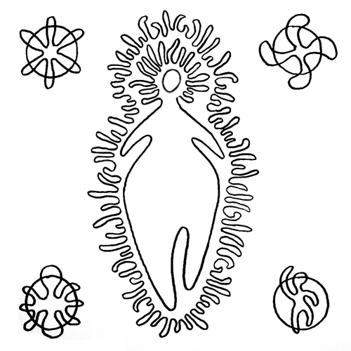
Mari, depicted in her "Woman of Fire"
guise (with squiggly bits) (CC2.5)
Nearby, and easily seen from the crossroads, is the Santuario de San Antonio. One of the largest and most revered shrines in the region, it occupies a site believed to have been the home of Mari, the greatest deity in the pre-Christian Basque religion. There is a tradition involving suspiciously pagan, pseudo-Freudian imagery that a young woman can increase her chances of finding a male partner by sticking pins in a cloth kept in the church - a white-headed pin will bring her a blonde man, a black-headed pin a dark-haired man.

The descent is neither challenging nor steep, consisting of long straights broken up by wide, sweeping bends all the way to the Urunagako Urtegia lakes where, after 153.6km, the race joins the N-240. We continue southwards past Legutiano and over a bridge crossing one arm of the lakes, then arrive 2.4km later at a junction on the left with the A-3006. This leads us to a junction with the A-267 2km away, where the race turns left under the AP-1 motorway. After another 2km, it reaches Landa, entered by way of a right turn onto a much narrower road, then right again a few metres later for the A-3002. 4.2km later, it reaches Ullibarri-Gamboa - a village that feels as though it's on the coast, standing on the banks of a vast lake named after the community - before the route follows the banks of the lake all the way to the wide dam that created it, continuing south into the countryside. A wide right/left U-shaped bend 0.2km after the dam leads to a crossroads, then onward to a medium 90 degree right 0.46km before entering Arroiabe.

Iglesia de Arroiabe (CC3.0)
Arroiabe's population has doubled since 2000, turning it into the present day sprawling metropolis home to 62 people. The village's pretty church stands on the southern edge, maintaining an air of serene separation from the earthly activities of those who live nearby - it's an impressive sight. 1.5km later the race arrives at Mendibil before skirting past Arazua-Ubarrundia and traveling underneath the E-5 motorway to Gasteiz (Vitoria on Spanish language maps). At the next roundabout, the race turns left and continues to the Zurbanoko Atea with several speed humps, turning left and then right for the Hezeguneen Ibilbidea. Left again at the next roundabout leads up to the Bulevar de Salburua and under the railway, the left again at the next roundabout (a long, elongated version) carries the race along the Calle Venta de la Estrella and, having negotiated another roundabout, the Itturitxu Kalea before it becomes the Zumabide Kalea running up to yet another roundabout and the Maite Zúñiga Kalea. Left at the following roundabout exits along the Martin Fixz Kalea, which becomes the Tanis Agirrebengoa Kalea before a tight right turn onto the Gaztelako Atea.

Gasteiz (CC3.0)
A final left leads along the Gasteizko Hiriburua and the final section, a straight and flat 700m sprint with the finish line at 185km.

Gasteiz, home to almost a quarter of a million people, is Euskadi's second largest city. Tradition states that it was founded by Visigoth king Liuvigild in the 6th Century as an attempt to emulate the grand Roman cities left behind with the fall of the Empire. Should this be true, his choice of location proved wise - the community was ideally placed to act as a hub of trade and communication between the Spanish central plateau and the north-western European nations, ensuring rapid growth in size, importance and wealth. As a port, it benefited early on from a multicultural society, with people from all around the Mediterranean, Europe and the wider world adding their skills and knowledge to the culture. The Jewish Quarter was one of the most important in Spain, a centre of learning and philosophy, prior to the Expulsion in the 15th Century. Long after they had been pushed out or forced on pain of death to convert to Christianity, Gasteiz did not forget its Jews - the old Jewish cemetery is preserved as a park, with a monument commemorating their contributions to the city. Gasteizit earned city status in 1431. It was the site of the decisive Battle of Vitoria in 1813 when the combined Spanish, Portuguese and British armies defeated the French, effectively bringing French control of the nation to an end.

As has been the case in Bilbao, the Basques demonstrate their seemingly effortless ability to combine centuries-old and cutting-edge contemporary architecture in a harmonious whole in Gasteiz - there's nowhere else in the world where venerable palaces and churches sit side-by-side with shining towers of glass and steel quite so successfully as they do in Euskadi. Among the churches are the Catedral de Santa María (the Old Cathedral), itself an expression of that Basque skill as it combines elements from the 13th Century to the present, and the Catedral de María Inmaculada (the New Cathedral), which looks medieval but is in fact a product of the Gothic Revival during the early part of the 20th Century and is unique for its Art Nouveau interior decorations. Among ancient architecture, highlights include the remnants of the medieval defensive wall, once 900m in length and completely encompassing the city as it stood when the wall was constructed; the early 13th Century Torre de Doña Otxanda, a superb example of medieval defensive architecture now put to excellent use as a museum of and centre of research in natural sciences which counts the oldest specimen of a butterfly ever discovered among its exhibits; the Museum of Fine Arts, housed in one of the best examples of a Renaissance palace; and, nearby, the 13th Century Torre de Mendoza - no decorative stately home, this one, designed solely with strength and ability to withstand attack in mind, could perhaps best be described as looking "purposeful." It currently houses a museum of heraldry.

Bibat - the seamless combination of ancient and modern into a harmonious whole.
Could there be anywhere else that symbolises the Basque Country quite so well?
For those who appreciate the modern, the ARTIUM is as good a place the start as any. This stunning white structure, built in 2001/2002, houses the Basque Centre-Museum of Contemporary Art and includes works by many of the greatest names in 20th and 21st Century art including Picasso, Miró, Jake and Dinos Chapman, Muñoz and Dali. Also not to be missed is the remarkable Museum of Archaeology, somehow looking as though it was always meant to stand next to the Museo Fournier de Naipes (the playing card museum) despite being separated by several centuries and an ocean of architectural difference: the former is housed in a strikingly contemporary building, the latter in a fortified medieval mansion. The amorphous whole, known as Bibat, is highly symbolic of both Gasteiz and Euskadi; an embodiment of that Basque tendency to remember what was good in the past while always striving for a better future.

Predictions: Yesterday proved an amazing day for the Basques - not only did the Vuelta return to their nation for the first time in more than three decades, the Basque rider Igor Anton achieved a superb stage victory; everything they and the legions of Euskaltel-Euskadi fans around the world hoped for. Now, can they do the same today? Or will Bradley Wiggins, now that a GC triumph appears to be out of his grasp, cut his losses and try to at least win a stage? Whatever happens, there's a good chance we'll see Chris Froome make one last effort to grab back those 13 seconds and catch Cobo.

Weather: A little cooler than Stage 19, starting out at around 25C before shifting up and down the scale between this figure and a low of 20C as the altitude changes during the first 140km. Following that, it's be warmer - rising from 27 to 28C - in the final 45km. Light crosswinds are expected up to 112km, then a light tailiwind for the remainder. No rain is expected anywhere on the parcours, but clouds in the latter half mean there's an outside chance of a few drops.

More Stage Previews: click here.