Showing posts with label Peking. Show all posts

Wednesday, 5 October 2011

Tour of Beijing - Stage 5 Guide

Stage Map: click here
Stage Profile: click here
Stage Itinerary: click here

As tends to be the case with stage races, the Tour winds up right in the heart of the capital city for the fifth and final stage; and with human habitation in the Beijing region stretching back a quarter of a million years (Homo erectus pekinensis - remember those chaps from Stage 2?) and the city having served as political and cultural centre of a country as vast as China for many centuries, there's a lot of history packed into the parcours.

A Polish monument to those murdered by the Chinese
Government in 1989 includes tank tracks on cobbles and,
representative of the Chinese people's lack of freedom,
a crushed bicycle.
(public domain image)
The roadbook once again gives a brief introduction, noting that when "tracing the history of Tiananmen Square, one cannot avoid mentioning the history and evolution of the ancient capital of Beijing." However, in this glossy  version of history, approved by a government that still bans all discussion of what happened, absolutely no mention is made of the year that made the Square infamous in the West: 1989 - when the government, afraid that peaceful, democratic protests were on the brink of becoming revolution, sent tanks and soldiers armed with assault rifles to attack unarmed civilians. 186 people are confirmed to have died - mostly on the streets nearby, rather than on the Square - but the true figure is still unknown. The Chinese government claims 241, but other estimates claim many more: according to Amnesty International, 1000; according to NATO, 7000; according to a document discovered following the fall of the Soviet Union, 10,000. The government in power in China today - the Communist Party of China - is still the same government that held power in 1989, and for all they now allow greater than ever before numbers of foreigners into the nation and make token nods towards democracy we should not forget that as recently as 2009, the 20th anniversary of the massacre, they still banned all protests, access by journalists to the Square and told all known dissidents in no uncertain terms to either leave Beijing or remain within their homes. Police shut down the Square and surrounding area during Stage 1, making fans pass through airport-style metal detectors and preventing large gatherings along the course, suggesting the security will be very tight during this stage. If protest disrupts proceedings, don't blame the protestors: some things are more important that a bike race.

The riders set out from the north-eastern corner of the Mao Zedong Memorial Hall (39°54'5.80"N 116°23'33.89"E), metres away from where the 10m tall, hastily-assembled Goddess of Democracy stood for five days before she was toppled by a tank and smashed to pieces by soldiers. It's a short neutral zone today, with the race well under way by the time the riders hit Chang An East Road after a loop around the Square and up to the southern approach to the Forbidden City. The Imperial Palace for almost five centures, the City covers 720,000 square metres and contains almost a thousand bstructures; many of them part of what UNESCO has declared the finest collection of preserved ancient wooden buildings in the world. Note that almost all of them having yellow roofs - yellow being the colour of the Emperor in ancient China, just as it is in cycling.

After passing by the grand hotels and Audi dealership that symbolise modern Beijing as much as the Forbidden City symbolises ancient Beijing, Chang An East crosses Dongdan North Street and becomes Jianguomen Inner Street before reaching the East 2nd Ring Road, then changes name again to Jianguomen Outer Street and runs for 2.28km to the East 3rd Ring Road. There are many very fine buildings - mostly modern but some old - on both sides of the road, one of the most imposing being the vast white edifice of the Beijing International Hotel topped by a revolving restaurant. A little further ahead on the right are the LG Twin Towers, the 20th tallest buildings in Beijing at 141m - stacked end on end, they'd still stop far short of the tip of the tallest, the China Central Television Tower which can be seen from the Forbidden City and stretches to 405m.

The Central Business District. The East 3rd Ring Road
heading north can be seen on the right and, under
construction, the China Central TV building.
(© CobbleCC CC3.0)
The race travels between the Central Business District skyscrapers, then underneath an elevated section of the East 3rd Ring Road and turns right to follow a slip road up onto the northbound lane. If you notice anything other than the China Central TV HQ building along the initial section of the road, you have excellent powers of observation - the structure is one of the most eye-catching buildings anywhere in the world and can easily distract attention from everything surrounding it. Rather than taking the standard vertical skyscraper shape, it features six vertical and horizontal sections and is one of the most ambitious architectural projects ever attempted. The shape seen from ground level has led to its nickname, first used by taxi drivers, of 大裤衩 - "the big boxer shorts."

After another 900m, the peloton pass to the left of the Solidify Lake Park with its traditional Chinese landscaping and temples looking somewhat at odds with the ultra-modern tall buildings surrounding it, then the Agricultural Museum a short while later before the route crosses the the wide Liangma River. The road bends to the left, passing over the Airport Expressway and a strangely, geometrically attractive interchange - at which point it becomes the North 3rd Ring Road East, soon bending left again and traveling underneath the Daguang Expressway. The peloton will continue for 2.9km, then arriving at a slip road leading up onto Beichen Road (39°58'2.46"N 116°23'28.63"E).

China Science and Technology Museum
(image courtesy of China-Tourist-Attractions.net)
On the left is a futuristic dome and a modern, spiral-shaped building, the two halls of the China Science and Technology Museum. A short way ahead, the race enters the Yuan Dynasty Capital City Wall Ruins Park, one of the very few places where Beijing's medieval defences can still be seen. Directly ahead, twin sculptures consisting of white marble bases with red top sections mark the entrance into the circuit 18km from the start on Beitucheng Road. It will be completed a total of twelve times with intermediate sprints beginning the second, sixth and ninth times the riders cross the finish line by the Water Cube.

Taking the road to the right of the sculptures, the riders continue north for 1.17km past the Yingdong Natatorium, more correctly known as the Ying Tung Natatorium after Henry Fok Ying Tung, a Beijing businessman who left a huge sum of cash so that the earlier buildings on the site - dating from the 1990 Asian Games - could be extended and developed to host some of the Olympics swimming events. They cross the North 4th Ring Road via the Beichen Bridge, then turn right onto the road immediately south of the Bird's Nest Stadium and follow part of the route used in the Stage 1 time trial in reverse, turning left after 390m for Hujing Road. 1.95km further on, they turn left onto Kehui South Road and continue for 520m west to another left onto Tianchen East Road. The finish line is in the same place as it was for Stage 1, 1.94km ahead at the East Gate of the Water Cube (39°59'26.97"N 116°23'7.86"E).

The Water Cube (public domain image)
For the first eleven circuits, the riders will continue straight over the finish line for 300m before turning left 82m later back onto Beichen Road, this time taking the carriageway to the west for 1.38km back over the North 4th Ring Road and as far as Beitucheng Road where they'll turn 180 degrees around the sculptures to begin a new circuit. Each complete circuit is 8km in length, which combined with the initial 18km section and final section to the finish line, the riders will have covered 118km at the end.

Tuesday, 4 October 2011

Tour of Beijing - Stage 4 Guide

Mutianyu (public domain image)
Stage Map: click here
Stage Profile: click here
Stage Itinerary: click here

The penultimate stage of this first ever Tour of Beijing is also the longest, covering 189.5km through the towns and countryside to the north of Beijing and makes two visits to the Great Wall - during the first, the riders will pass through the Wall at Huanghuacheng, where two stretches are joined by a dam; and at the second they'll leave the main route to complete a short circuit up to Mutianyu and back - the best-preserved, best-built and most spectacular of the several sections of defences forming the Wall as a whole. It ends at the Shunyi Rowing-Canoeing Centre with its several kilometres of lakes, rivers and white-water courses purpose-built for the Olympics.

The Guyaju Ruins in Yanqing County were once occupied
by the Kumo Xi, a tribe of fierce Mongolian warriors
(© pfctdayelise CC2.5)
The neutral zone begins at the Gui Chuan Square in Yanqing, capital town of Yanqing County - the exact route is, once again, not terribly clear from details in the roadbook. Having left the Square, the peloton travels east for a while along the Hubei Road before crossing the river and joining Binhe Road heading west at some unspecified point, we think most likely the Yongxi Highway crossing. Directions for the first 17km remain unclear - one road, the G101, doesn't seem to exist and is presumably a misprint for the G110. This, says the itinerary, should be followed until the beginning of a 1km section on Hubei Road again; but this appears to bear little correlation to either the road layout or what is shown on the official map. Since we need to get to Hunan Road, we think the most likely route would be to continue on Binhe Road as it crosses the G110, arriving at the S216 just over 0.5km later - the two roads are also known as the Jingyin and Old Jingyin Roads, making entirely feasible the idea of a route planner becoming confused. Turning right and then left 400m later brings the race onto Hunan East Road, with the stage's first intermediate sprint beginning some 500m later (40°27'15.67"N 115°59'33.15"E).

2km ahead, the route reaches what the roadbook states to be Yanqing Road but maps state is Yankang Road, turning left and then right at the next junction for Huanhu Road. We're now directed to find Kang Hang Road - trouble is, the road registered under that name is in Singapore - as we need to get to the S217, we assume the correct road is the one beginning at 40°26'58.84"N 115°57'34.54"E and ending at 40°26'33.87"N 115°52'42.83"E, where the peloton turn right towards another section of the G110 approximately 4km away followed by another unspecified route to find the X020 County Road (we think they'll turn left and travel west for a short way on the G110, then right and north on the X012 County Road and right again to continue east on the X020 - the official maps seem to support this). Somewhere along this road, with 51km covered since the end of the neutral zone, the second intermediate sprint begins. Towards the end of the road, we'll have excellent views of the mountains to the left, over 1000m high. Another not very clearly-pointed out section leads to the S232 road, apparently via the X026 - however, the X026 is a considerable distance away to the south in Beijing.

Mutianyu is 2.25km long and has 22 watchtowers. Whereas
other sections are built of bricks, earth and whatever was
available, here the structure is granite.
(© Fabian Dany CC2.5)
We then follow the S232 east, reaching the feed zone 97.5km from the start. Riders will want to take on board a decent amount of energy gels - attentive readers will have spotted the lack of climbs in the first half of this stage. The first, a Cat 3, starts 4.5km after the feed zone and, having already climbed for some distance, the riders will need to climb 132m in 2.5km to reach the top. The descent is long and fast.

We remain on the S232 as far as Sihaizhen where we turn right, right again and left to join Ansi Road, leading 20km to Huanghuachengcun (note that on the official Tour website, the village is misspelled Huang Hui Zhen). It's here that the race passes by the dam connecting two stretches of Great Wall. Since 2010, there have been numerous eyewitness reports made by people who claim to have seen a large, fiery object falling to Earth in the area on the night of October the 30th - this has, naturally, got UFO fans hot under to collar. Whatever the object was - indeed, if the object ever was - there have been no corresponding accounts of aircraft in trouble nor wreckage/craters on the mountainsides.

Now we join the X009, leading through Huanghuazhencun - the probable cause of the of the confusion a few kilometres previously). The second climb, 159m in 4km, is rated Cat 2 and begins 125km from the start - that category seems a little more than would be expected, suggesting that the road isn't of the best quality. It's also very twisty as it climbs and could potentially be dangerous if wet (or while being bombarded with mysterious fiery UFOs). The summit comes at the entrance to the Tuoling Tunnel (40°24'9.66"N 116°23'32.82"E) which, as tends to be the case with tunnels in rural China, is unlit - it's short, but the riders won't like it due to the hazard it presents.

Having emerged back into daylight, the race follows the road right and descends quickly through Sha Yu Village before arriving at Bohaizhen Bridge 3km later. The right turn onto it is tight, but the bridge is wide and of good quality so crashes are unlikely. Bohaizhen Town is around 1.6km ahead. The stage's final climb begins 3.5km later at a large roundabout (40°24'53.05"N 116°32'19.11"E) where the race turns left, entering the circuit up to Mutianyu (40°25'59.83"N 116°33'33.35"E) and back down again. It's remarkable that this section - which, as we mentioned earlier, is the best-preserved along the Wall's length - has survived so intact: in the years following the Cultural Revolution, the Maoist government declared the Wall to be a symbol of the nation's feudal past and encouraged the populace to help themselves to as much of the masonry as they could cart away, even demolishing some parts to assist them. Were it not for the craggy ridge followed by this section, its proximity to Beijing would almost certainly have ensured its destruction.

We at Cyclopunk do not believe in ghosts,
UFOs or any of that stuff. However, we
wouldn't hang around Mutianyu alone for
any length of time just in case.
(CC3.0)
As if the UFOs around the last section of wall weren't sufficient weirdness for one stage, this section is said to be haunted by the Mutianyu Phantom. A legend dating from just the late 1990s, the Phantom is said to be the ghost of a local woman killed by an explosion at the factory where she was employed making the trinkets still sold to tourists who visit the area. Her first victim was a German woman in 1997; her family reporting that the victim had mentioned seeing a woman dressed in black, with a black veil and white gloves, pointing at her several times throughout the day when they visited the Wall. Then, later in the day, the victim vanished and has  never been seen again. The next victim was another tourist named Benjamin Heffemburg - he too saw the mysterious woman in black, reporting his sightings to his family, and the next day was discovered dead in his hotel room - his body surrounded by shards of shattered glass. Several more disappearances have been blamed upon the Phantom, whom some locals now warn tourists to avoid at all costs. Since she only attacks foreigners, the locals are not afraid of her and as a result have been able to get close enough to have a better look (or have perhaps realised that there's nothing like a good ghost story to intrigue rich visitors), now explaining that her white gloves are in fact bandages and the veil hides a hideously deformed face.

The final intermediate sprint begins 13km after the summit, 167km into the race, then the peloton continue on the X009 as it becomes Huaisha Road and travels along the northern edge of Huairou Reservoir, arriving presently at a very large roundabout (40°20'7.79"N 116°37'28.62"E) where they'll turn right for Qingchun Road. Having followed it south to Nanhua Street, they turn left and follow the road around a bend to a wide bridge; taking the first left turn at the next roundabout for Huaichanglian Road and, after 1.73km, an interchange with a right turn onto Jingmi Road heading south - they'll follow this road for 13.27km through a number of further interchanges, rural areas and industrialised urban complexes until they reach the left-hand slip road leading down onto Baima Road (40°10'31.03"N 116°38'8.58"E), at which point they have 5km left.

Shunyi's entirely man-made white-water slalom course
is considered one of the most testing in the world
(© Gerry Boudens CC3.0)
Now traveling east, they soon cross Shun'an North Road with 3km left to go. The horse racing stadium passes by on the right, then Youdi Road and the Beijing Country Club golf course before the route crosses a wide bridge. The flamme rouge is on the bridge, marking the final kilometre, then the road bends very slightly right as we enter the final sprint - an last section for the sprint specialists up to the finish line by the plaza in front of the Shunyi Park (40°10'7.58"N 116°41'7.65"E).

Monday, 26 September 2011

Tour of Beijing - Stage 1 Route Guide

Stage Map: click here
Stage Profile: click here

The riders couldn't wish for a flatter course than the Stage 1 time trial in the Chinese capital - it starts and ends at 41m and, with the exception of the briefest of blips after around 4km, doesn't really rise any higher along the entire route. With several straight sections and few dangerous bends, it leads north into the Olympic Park where it follows smaller, winding roads for a short while before heading south then back into the city along more straight roads for a final 300m sprint, this is a parcours that will favour sprinters as well as time trial experts and may very well generate new speed records.

The Bird's Nest (© 老黄瓜 CC2.5)
As will also be the case with Stage 2, the route begins at the famous Beijing National Stadium (39°59'28.54"N 116°23'13.94"E): one of the world's most iconic buildings and commonly known as the Bird's Nest for the seemingly random placing of the steel beams from which the outer shell is constructed - however, as is the case with a real bird's nest, there's nothing random about it at all. The completion of the National Stadium
"Bird's Nest" is something that all the
Chinese people are proud of, according to the official race road book - possibly because the government told them to be. After riding north for 591m, riders turn 90 degrees left onto the National Stadium North Road whilst taking care not to hit the grassy verges separating the cycle paths running along both sides of the road  - whereas these will be lined with barriers, it should be noted that Chinese trucks do not need to abide by the same regulations as do those in many other nations and as such, a corner in a busy location such as this is very much subject to diesel spills - one of the hazards most feared by cyclists because the fuel is impossible to see and lethal, especially after rain. On the right, just before the turn, is the 128m Long Long Pagoda - not actually a pagoda at all, but the Olympics international broadcast centre.

Ling Long Pagoda (© Kyle Simourd CC2.0)
The next turn, a 90 degree right, comes 138m later and leads onto Tianchen East Road continuing north for 974m past the China National Convention Centre on the left, housed in the building that originally served as the location of the Olympic press centre and venue for pistol and fencing events. Random fact: the centre's central vacuum cleaning system is the largest in China with 15.8km of piping.

Passing by some of the 2.2 million trees planted around the Olympic site (because the Chinese government like to pretend they're concerned about the environment when there are foreign press about), the riders soon arrive at Kehui South Road (40° 0'19.69"N 116°23'5.35"E) ready for another 90 degree left, this time avoiding the central reservation in addition to the grassy verges (the official road book has not yet been published, so at present we don't know if both carriageways will be open). After crossing Tianchen West Road 204m from the turn, they come to a 90 degree right onto Beichen West Road 110m later. Caution is required again due to a central reservation. Just west of the corner is the Institute of Remote Sensing Applications, occupying the splendidly-named Nanlongwang Hall. The difficulty of the turn depends largely upon which carriageways are in use - if the left, it's a wide and easy section; if right, it becomes much tighter and especially hazardous when wet due to the pedestrian crossing just around the apex.

Having crossed Kehui Road 304m to the north, the riders continue straight ahead on Aolin West Road as it snakes around the western perimeter of the beautiful Olympic Forest Park, a man-made area of forest and lakes almost 2km wide. They'll be on the right carriageway here, as the next turn in impossible from the left. It bends gently left, then passes under a fly-over and past the site of the two Olympic hockey stadia that were taken down after the Games, then bends right and left again before crossing a bridge over the N 5th Ring Road, then following the narrow slip road to the right 128m after the bridge (40° 1'20.74"N 116°22'48.69"E)  down to a very tight right 300m later - a point where significant time could be lost through punctures caused by thorns from the overhanging trees.

A bridge 186m along the road is only very narrower than the road and as such should cause no problems since riders are crossing one at a time. More overhanging trees past the bridge may result in more punctures and there's another very tight right turn 400m after the bridge is left behind, this one made more difficult by a kinked entry (40° 1'27.29"N 116°23'9.87"E). There's an 80 degree right 181m ahead, followed by an equally tight left onto a narrower road 30m later where riders reach the intermediate checkpoint and we get early indication of their performances.

One venue we won't see is the Laoshan Velodrome,  one
of the finest in the world. Built for the Olympics, it's
hosted several cycling events since.  (© Doma-W CC3.0)
Shortly after the checkpoint is what must be one of the most remarkable motorway bridges anywhere in the world. Though some 50m wide - arguably making the passage below it a short tunnel rather than the passage across a bridge - the road on Tianchen Bridge is only around 5.5m wide, the space either side being landscaped and covered in trees and shrubs to form a continuation between the parkland to the north and south. At the road on the other side, riders turn 90 degrees left, ignoring the bridge south over the river and proceed for 805m past a car park and on to Aolin East Road for a right turn to head south.

Having passed under a fly-over, the road bends slightly right and then left before crossing Kehui Road and arriving at the next turn 259m later - a right onto Kehui South Road with caution again required to avoid the central reservation if both lanes are in use. As another busy urban route, diesel spills are a possibility; as may also be the case at the left turn 224m later onto Hujing East Road.

The Water Cube at night (public domain image)
Hujing East curves gently around a bend in the river, crossing five other roads before arriving at the National Stadium South Road 1.93km later and offers some of the best views of the Bird's Nest. On the left is the enormous 5-star Grand Skylight CATIC Hotel, then the riders turn 90 degrees right onto a bridge. The road narrows at the opposite bank to make room for traffic emerging from a central tunnel (39°59'18.16"N 116°23'28.36"E), then opens up again 269m after the corner. It then continues for a further 279m, crossing the wide boulevard past the stadium upon which the route began before reaching the final turn - a 90 degree right onto Tianchen East Road. From this point, there are 300m left to the finish line next to the National Aquatics Centre, better known as Water Cube; a striking building clad in 4000 plastic bubbles.

Saturday, 24 September 2011

Tour of Beijing

The Race

It's not every day that we get to see the inaugural edition of a brand new UCI World Tour, and it's even rarer that such an event takes place in a nation that, until very recently, was so restrictive that the idea of a major international bike race taking place within its borders was all but unthinkable.

That's why the 2011 Tour of Beijing is a little bit special. What's more, with events such as this, the links between the Chinese people and the rest of the world are strengthened - and when that happens, as we saw in the old Eastern Europe, the iron fist with which the Chinese government still rules the populace and crushes dissent begins to rust (and as an example of that socio-political repression, it's quite likely that Cyclopunk will very soon not be making it through the Great Firewall of China which aims to prevent any website critical of the government finding its way into the country).

Of course, professional cycling isn't new in China - it was only three years ago that the nation hosted the Olympic Games. It also hosts no less than four of the 31 races making up the UCI Asia Tour, created by the cycling body in an attempt to sow the seeds of the sport outside of its European natural habitat (the others being the Tour of Hainan, the Tour of Qinghai Lake, Tour of South China Sea and the Tour of Taihu.

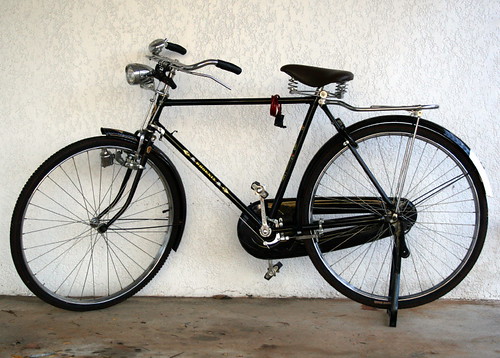
Develop your skills for 15 years on a bike like this+enter
local races+get signed by a team+get given a modern
carbon fibre bike=win loads of races. Bring on the Glorious
Chinese Cycling Revolution! (from Through Balanda Eyes)
Remember the late 80s and early 90s when Eastern Europe and the USSR began to open up, allowing a tidal wave of pop culture, rock music, video games and Big Macs (it can't all be good) to flood across the border while they sent a stream of hard-as-nails cyclists, steely-eyed boys with muscles honed by years of getting up for 4am rides on standard black bicycles that weighed more than they did at the grim Sports Akademies our way in return? Ullrich, Ekimov, Vinokourov, Kasputis and, perhaps the hardest of them all, Voigt? And remember the effect they had on the European cycling scene, blowing races wide apart and raising the level of competition so high that new notches had to be cut?

China today is where Russia, Romania and East Germany were in 1990. Of course, professional cycling isn't new in China - it was only three years ago that the nation hosted the Olympic Games. It also hosts no less than four of the 31 races making up the UCI Asia Tour, created by the cycling body in an attempt to sow the seeds of the sport outside of its European natural habitat (the others being the Tour of Hainan, the Tour of Qinghai Lake, Tour of South China Sea and the Tour of Taihu, all of which increase its popularity among the nation's 1.33 billion population, creating new fans. Many of those are kids from poor families, boys and girls who are still riding heavy black bicycles that have more in common with a farmyard gate than the razor blades of carbon fibre that now dominate in the Tours, and they're going to look at cycling and think, "hey - I could do that!" and with the determination of hungry kids who have seen a way out of poverty, they'll practice on their agricultural bikes. Then they'll enter local races organised by people inspired by the UCI, where they'll get noticed by teams who will supply them with modern kit - and then, they'll do what the East Europeans did. There's a new revolution coming in the next decade, and professional cycling will be all the better for it.

National Stadium, Beijing (© Chumsdock Cheng CC2.0)
So, between the 5th and the 9th of October we get to see top-notch bike racing, help free the Chinese people from tyrannical rule and take another step along the way to the future of cycling. That, by all definitions of the term, is a win-win situation.

The Stages

Race Map: click here
Stages and Profiles: click here

Stage 1 is a short 11.3km individual time trial from the National Stadium, more popularly known as The Bird's Nest, on the Olympic Green 8.23km from the Zijin Cheng Forbidden City in the city centre. It heads north into the Olympic Park, then back south and around the Stadium to the National Aquatics Centre, also known as theWater Cube - a flat, fast parcours with a number of tricky corners thrown in to keep things interesting.

Stage 2 once again starts at the National Stadium, but this time the riders head west out of the city looping into the beautiful countryside to the north-west of the city, then complete two short circuits, one long circuit and one medium circuit around Mentougou (if you're looking for it on Google Earth, try this spelling rather than the official itinerary's Men Tau Gou - or just search 39°56'23.51"N 116° 5'54.24"E) and three Category 4 ascents to 183m before reaching the finish line in the town after 133.5km.

Stage 3 brings the first of the proper climbs - three Cat 1s and a Cat 2 add up to around 1700m of skyward pedaling - that's comparable to an ascent of the Col d'Aubisque. The first sprint of the day takes place on an uncategorised climb 17km after the first Cat 1, beginning at 800m and reaching the highest point of the stage. The second sprint comes at the bottom of the steep descent that follows the first and is likely to be taken at blindingly fast speed. 162km long, the stage ends in Yongningzhen (Yongning in the roadbook, Yongning Town on the official race map). En route, we get our first look at China's most famous feature. the Great Wall.

Shunyi's whitewater course is considered exceptionally
difficult, even by Olympic standards (© Gerry Boudens CC3.0)
Stage 4, the longest in the race, begins at Guichuan Square in Yang Qing, heading east and then looping west again for an initial 20km circuit before arriving back at Yang Qing. Having completed the first sprint, riders travel west, then east and along the southern perimeter mountain range at that end the North China Plain. After turning back towards Beijing, it once again reaches the Great Wall - with a Cat 3 climb up to it - then heads back into the city to finish at the Shunyi Olympic Rowing-Canoeing Centre, an amazing facility with lakes and a custom-built whitewater course created especially for the Games 189.5km after the start.

Stage 5 takes the race back onto the flats with twelve circuits beginning at Tian An Men Square in the heart of Beijing - at 440,000 m² (0.88km x 0.5km), the largest city square anywhere on Earth and ending with a triumphant return to the National Stadium.

Tian An Men Square